Menu
  • Home
  • Breaking News
  • Feature
    • Arts
    • Astrology
    • Business
    • Community
    • Employment
    • Event Stories
    • From the Pioneer
    • Government
    • Letters to the Editor
    • Non Profit News
    • Obituary
    • Public Safety
    • Podcast Interview Articles
    • Pioneer Pulse Podcast: Politics, Palette, and Planet – the Playlist
  • Weather
  • Guest Column
    • Perspectives
    • Don Backman Photos
    • Ardent Gourmet
    • Kitchen Maven
    • I’ve been thinking
    • Jim Heffernan
    • The Littoral Life
    • Neal Lemery
    • View From Here
    • Virginia Carrell Prowell
    • Words of Wisdom
  • Things to do
    • Calendar
    • Tillamook County Parks
    • Tillamook County Hikes
    • Whale Watching
    • Tillamook County Library
    • SOS Community Calendar
  • About
    • Contribute
    • Advertise
    • Subscribe
    • Opt-out preferences
  • Post Submission Test
  • Search...
Menu

TILLAMOOK COUNTY EMERGENCY MANAGEMENT: Gordon’s Update – Weather 11/15/21

Posted on November 15, 2021 by Editor

By Gordon McCraw, Tillamook County Emergency Management

Monday, November 15, 2021, 08:30am

Weather

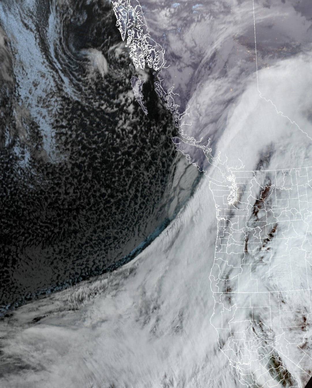
The atmosphere river that has spent the weekend in Canada and Washington is now moving and will impact our weather later this morning and afternoon.  We can expect increasing rain as the system nears along with gusty winds as the system starts to accelerate toward the southeast. The winds are already starting to get gusty at the beaches, gusting to 25 but it is expected to increase as the system crosses.

So, the impacts locally with this system, we can expect increasing rain that could be heavy at times as the system races through, winds becoming southerly 14-18 gusting to 25 but increasing as the front moves thru, becoming southwesterly 20-30 gusting to 40 inland.  At the beaches, they could see winds as high as 40-50 gusting to 70 with areas like Rockaway and Cape Meares seeing winds 30-40 gusting to 50-60.  Winds in Astoria are already gusting to near 50 at the airport. This could lead to some power outages and downed trees so now is a good time to make a plan in case it happens.  The National Weather Service in Portland has issued a High Wind Warning that includes the North Oregon Coast until 1pm today. This system will likely give the valley some wind issues as well.  As far as rain, it looks like we will get around an inch with this system.  While this will cause increased flows in the rivers, which are still somewhat elevated from the last system, none are forecasted to reach Action or Flood Stage. The last item to mention is the temperatures behind the front.  The temperature today will max out around noon at 60 degrees but then begin to fall.  By later this afternoon the temperature will have fallen to around 49 but with the winds, it will feel much cooler.

The temperature will continue to drop tonight which also pulls the snow level down to around 2500’.  As scattered showers are likely behind the system, higher Coast Range mountains could be seeing snow.  Winds are expected to be westerly 5-10 tonight but the lows drop to near 37 so frost is possible in some locations.

A high pressure ridge builds in tomorrow which will bring improving conditions with light winds.  By the afternoon we likely reach 51 under mostly sunny skies.  We see light easterly winds tomorrow night with the lows dropping to near 36.

Wednesday, we see more clouds returning ahead of another system that will bring rain into the area early Thursday morning though there are still some model differences with this system.  While the models show less than an inch of precipitation in the 24 hour period, the models disagree on how fast the system moves or exactly where it will go. The path would impact the amount of winds we would receive. Some of the models put the associated low pressure area into northwest Oregon/southwest Washington Thursday or Friday and some intensify or deepen the low as it moves ashore while others weaken the system.  Future models hopefully will come into better alignment to increase the confidence in the forecast.

Given the above, we would see a chance of showers Friday night into Saturday with some drying on Sunday before another system brings a chance of rain into Monday.


Featured Video

Slide Contribute SUBSCRIBE

Tillamook Weather

Tides

Tillamook County Pioneer Podcast Series

Tillamook Church Search

Cloverdale Baptist Church
Nestucca Valley Presbyterian
Tillamook Ecumenical Service

Archives

  • Home
  • EULA Privacy Policy
  • Contact
  • Opt-out preferences
  • Search...
Share on facebook
Facebook
Share on pinterest
Pinterest
Share on twitter
Twitter
Share on linkedin
Linkedin
Catherine

Recent Posts

  • Grove avenue closed in Tillamook for maintenance

    May 10, 2025
  • Astoria Farmers Market new, outdoor location with parking, with great Riverwalk access

    May 10, 2025
  • WORDS OF WISDOM: Boycotts and Protests in our Community Garden

    May 9, 2025
©2025 | Theme by SuperbThemes

Manage Cookie Consent
To provide the best experiences, we use technologies like cookies to store and/or access device information. Consenting to these technologies will allow us to process data such as browsing behavior or unique IDs on this site. Not consenting or withdrawing consent, may adversely affect certain features and functions.
Functional Always active
The technical storage or access is strictly necessary for the legitimate purpose of enabling the use of a specific service explicitly requested by the subscriber or user, or for the sole purpose of carrying out the transmission of a communication over an electronic communications network.
Preferences
The technical storage or access is necessary for the legitimate purpose of storing preferences that are not requested by the subscriber or user.
Statistics
The technical storage or access that is used exclusively for statistical purposes. The technical storage or access that is used exclusively for anonymous statistical purposes. Without a subpoena, voluntary compliance on the part of your Internet Service Provider, or additional records from a third party, information stored or retrieved for this purpose alone cannot usually be used to identify you.
Marketing
The technical storage or access is required to create user profiles to send advertising, or to track the user on a website or across several websites for similar marketing purposes.
Manage options Manage services Manage {vendor_count} vendors Read more about these purposes
View preferences
{title} {title} {title}