Menu
  • Home
  • Feature
    • Breaking News
    • Arts
    • Astrology
    • Business
    • Community
    • Employment
    • Event Stories
    • From the Pioneer
    • Government
    • Letters to the Editor
    • Non Profit News
    • Obituary
    • Public Safety
    • Podcast Interview Articles
    • Pioneer Pulse Podcast: Politics, Palette, and Planet – the Playlist
  • Guest Column
    • Perspectives
    • Don Backman Photos
    • Ardent Gourmet
    • Kitchen Maven
    • I’ve been thinking
    • Jim Heffernan
    • The Littoral Life
    • Neal Lemery
    • View From Here
    • Virginia Carrell Prowell
    • Words of Wisdom
  • Weather
  • Post Submission
  • Things to do
    • Calendar
    • Tillamook County Parks
    • Tillamook County Hikes
    • Whale Watching
    • Tillamook County Library
    • SOS Community Calendar
  • About
    • Contribute
    • Advertise
    • Subscribe
    • Opt-out preferences
  • Search...
Menu

GORDON’S UPDATE: Weather – 3/3/23 … Whether it will be rain or snow? Rain-maybe, snow/rain-maybe, snow

Posted on March 3, 2023 by Editor

EDITOR’S NOTE: Gordon didn’t mention the Coast Range passes – there is a winter storm warning for heavy wet snow (up to 12″) throughout the weekend; and a hazardous seas warning for mariners. So be prepared for winter driving conditions over the passes, and mariners are advised to stay in port until the seas subside. The calendar might say March but Winter still has a grip on us.

By Gordon McCraw, Meteorologist for the Tillamook County Pioneer
Friday, March 3, 2023

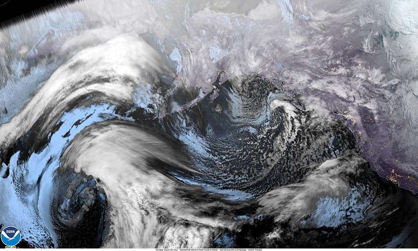
The satellite picture clearly shows a low pressure area west of British Columbia and another in the Gulf of Alaska. These will be the weather makers after today as the lows are forecasted to drift southward thru the weekend and settle off the coast of Washington and Oregon where they sit for much of next week. This will bring us showers and cooler temperatures that could give us some low level snowshowers and possibly some patchy ice from late night thru the early morning hours while dumping more snow through the passes.

Today, isolated showers and the forecast for tonight is for more scattered showers and possibly some thunderstorms, and some of these heavier showers could give us some small hail. Winds tonight southerly 10-15 gusting to 25, the low near 36, the snow level 1400’ but falling down to near 1000’ after midnight, but briefly lower in the heavier showers.

Showers persist tomorrow, Saturday, some bringing brief periods of low level snow thru mid-morning, still a slight chance of a thunderstorm, winds southerly 14-18 gusting to 25, the high near 44, the snow level lifting back up near 1500’. Still the showers with possible thunderstorms tomorrow night, the snow level falling to 1000’ again, then down to or below 500’ after midnight, winds southerly 8-12, lows dropping to near 32 so low level snowshowers possible after midnight.

A chance of snowshowers thru midmorning again Sunday, winds southerly 5-10, the high near 46, the snow level lifting to near 1000’. More rainshowers Sunday night, the snow level falling to near 500’ again, the overnight temperatures falling to near 33 so low snowshowers possible in the early morning hours again.

A chance of showers Monday, possibly more low snow showers thru mid-morning as the snow level starts lifting to near 1000’, the high near 45. A little warmer that night, the low down to near 35, the snow level around 1300’.

Mostly cloudy and rainy Tuesday, the snow level around 1500’, highs near 44, the showers continue Tuesday night, the snow level back down to 1000’, lows near 35.

Showers likely still Wednesday, the snow level around 1500’, highs near 44, more showers Wednesday night, the snow level down to 1000’, lows still around 35.

Things look a little warmer Thursday, the high near 48, still that chance of showers, the snow level climbing from 1500’ that morning to 2700’ that afternoon.

Some of the models continue to show an atmospheric river setting up after this, still too far out to offer any credible details just yet.

And this is your first warning, we will be springing forward Sunday, March 12, 2023 at 2:00am. The time change is right around the corner! Also, if things seem to be getting weird, we have a full moon coming next Tuesday, the 7th. One result for sure is slightly higher tides during that period.

Slide Slide Slide Slide Slide Slide Slide Slide Subscribe Contribute

Ads

Featured Video

Tillamook Weather

Tides

Tillamook County Pioneer Podcast Series

Tillamook Church Search

Cloverdale Baptist Church
Nestucca Valley Presbyterian
Tillamook Ecumenical Service

Archives

  • Home
  • EULA Privacy Policy
  • Contact
  • Opt-out preferences
  • Search...
Share on facebook
Facebook
Share on pinterest
Pinterest
Share on twitter
Twitter
Share on linkedin
Linkedin
Catherine

Recent Posts

  • ROCKAWAY BEACH READIES FOR JULY 4TH FESTIVITIES - HONORS VOLUNTEER OF YEAR & PARADE GRAND MARSHAL

    June 30, 2025
  • NEWS UPDATE FROM STATE REPRESENTATIVE DAVID GOMBERG: It's a Session Wrap!

    June 30, 2025
  • GORDON'S WEEKLY WEATHER UPDATE 6/30/25: Back to Normal Summer Weather This Week - Fair, Dry & Mild; Holiday Weekend Weather Looks Good

    June 30, 2025
©2025 | Theme by SuperbThemes

Manage Cookie Consent
To provide the best experiences, we use technologies like cookies to store and/or access device information. Consenting to these technologies will allow us to process data such as browsing behavior or unique IDs on this site. Not consenting or withdrawing consent, may adversely affect certain features and functions.
Functional Always active
The technical storage or access is strictly necessary for the legitimate purpose of enabling the use of a specific service explicitly requested by the subscriber or user, or for the sole purpose of carrying out the transmission of a communication over an electronic communications network.
Preferences
The technical storage or access is necessary for the legitimate purpose of storing preferences that are not requested by the subscriber or user.
Statistics
The technical storage or access that is used exclusively for statistical purposes. The technical storage or access that is used exclusively for anonymous statistical purposes. Without a subpoena, voluntary compliance on the part of your Internet Service Provider, or additional records from a third party, information stored or retrieved for this purpose alone cannot usually be used to identify you.
Marketing
The technical storage or access is required to create user profiles to send advertising, or to track the user on a website or across several websites for similar marketing purposes.
Manage options Manage services Manage {vendor_count} vendors Read more about these purposes
View preferences
{title} {title} {title}