Menu
  • Home
  • Feature
    • Breaking News
    • Arts
    • Astrology
    • Business
    • Community
    • Employment
    • Event Stories
    • From the Pioneer
    • Government
    • Letters to the Editor
    • Non Profit News
    • Obituary
    • Public Safety
    • Podcast Interview Articles
    • Pioneer Pulse Podcast: Politics, Palette, and Planet – the Playlist
  • Guest Column
    • Perspectives
    • Don Backman Photos
    • Ardent Gourmet
    • Kitchen Maven
    • I’ve been thinking
    • Jim Heffernan
    • The Littoral Life
    • Neal Lemery
    • View From Here
    • Virginia Carrell Prowell
    • Words of Wisdom
  • Weather
  • Post Submission
  • Things to do
    • Calendar
    • Tillamook County Parks
    • Tillamook County Hikes
    • Whale Watching
    • Tillamook County Library
    • SOS Community Calendar
  • About
    • Contribute
    • Advertise
    • Subscribe
    • Opt-out preferences
  • Search...
Menu

GORDON’S UPDATE: Weather 4/10/23 – Come on Spring!

Posted on April 10, 2023April 10, 2023 by Editor

By Gordon McCraw,
Monday, April 10, 2023

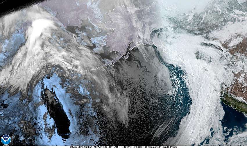
Well, the forecast verified, the atmospheric river (AR) event gave us winds gusting from 25 to 30 at the airport yesterday with gusts from 40 to 45 at the beaches, and stations have reported from just under 1” to a little over 2” of rain except one personal weather station up the Miami River reported nearly 3 ½” of rain. It looked like South Fork recorded 1 ¾” of rain. This did cause a rapid rise in the rivers that all crested a little after midnight, several feet below Action Stage. The forecasts have them all continuing to drop over the next several days. At this point it looks like the event peaked last night and rainfall rates decreased as the AR drifted north and south during the day today.

So, this evening, the associated upper level trough of low pressure over the eastern Pacific will get closer to the coast and drag a cold front across which, besides bringing in more rain, will start to push the snow level lower, falling to near 2000’ tonight as the low temperature drops to near 39. The winds becoming southerly this evening 5-10.

Tomorrow, we see scattered showers with a chance of afternoon thunderstorms. Winds becoming westerly 10-15 gusting to 20, the high near 49. Now, tomorrow night it looks like a low pressure area will move into southern Washington and that would enhance the shower activity while bring westerly winds 10-15 gusting to 25, and also pull in some colder air, dropping the snow level below the summit level as it lowers to near 1200’ after midnight and possible even giving some flurries or a rain/snow mix at times down to 500-1000’ in the heavier showers.

Wednesday the wind and shower activity will slowly ease under partly sunny skies, becoming more widely scattered before diminishing Wednesday night. High temperatures Wednesday afternoon around 50, the low that night near 34, luckily the shower activity will have dissipated in these colder temperatures.

Thursday a weak trough moves across and gives us a chance of showers, the snow level that will start out around 1200’ that morning, will climb to near 1800’ in the afternoon so there is a slight chance of morning snowshowers in the higher passes.

After that the models look to build a ridge over the area. The mixed signals though are in placement and strength. This will drive how warm we get Friday through the weekend. The variation is from average high temperatures for this time of year, to above average for this time of year. For now though, we will go with highs in the upper 50s for the weekend, and lows in the low 40s. Unfortunately, it also looks like a low pressure area will be dropping south, west of Vancouver Island so we do have a chance of showers developing Saturday night into Sunday.

Come on spring 😊

Slide Slide Slide Slide Slide Slide Slide Slide Subscribe Contribute

Ads

Featured Video

Tillamook Weather

Tides

Tillamook County Pioneer Podcast Series

Tillamook Church Search

Cloverdale Baptist Church
Nestucca Valley Presbyterian
Tillamook Ecumenical Service

Archives

  • Home
  • EULA Privacy Policy
  • Contact
  • Opt-out preferences
  • Search...
Share on facebook
Facebook
Share on pinterest
Pinterest
Share on twitter
Twitter
Share on linkedin
Linkedin
Catherine

Recent Posts

  • 4th of July Happenings throughout Tillamook County

    July 3, 2025
  • WHAT DOES FREEDOM MEAN TO YOU? I've been thinking ... Liberty to me

    July 3, 2025
  • INDIVISIBLE TILLAMOOK COAST: The largest betrayal of the American people.  Period.

    July 3, 2025
©2025 | Theme by SuperbThemes

Manage Cookie Consent
To provide the best experiences, we use technologies like cookies to store and/or access device information. Consenting to these technologies will allow us to process data such as browsing behavior or unique IDs on this site. Not consenting or withdrawing consent, may adversely affect certain features and functions.
Functional Always active
The technical storage or access is strictly necessary for the legitimate purpose of enabling the use of a specific service explicitly requested by the subscriber or user, or for the sole purpose of carrying out the transmission of a communication over an electronic communications network.
Preferences
The technical storage or access is necessary for the legitimate purpose of storing preferences that are not requested by the subscriber or user.
Statistics
The technical storage or access that is used exclusively for statistical purposes. The technical storage or access that is used exclusively for anonymous statistical purposes. Without a subpoena, voluntary compliance on the part of your Internet Service Provider, or additional records from a third party, information stored or retrieved for this purpose alone cannot usually be used to identify you.
Marketing
The technical storage or access is required to create user profiles to send advertising, or to track the user on a website or across several websites for similar marketing purposes.
Manage options Manage services Manage {vendor_count} vendors Read more about these purposes
View preferences
{title} {title} {title}