Menu
  • Home
  • Feature
    • Breaking News
    • Arts
    • Astrology
    • Business
    • Community
    • Employment
    • Event Stories
    • From the Pioneer
    • Government
    • Letters to the Editor
    • Non Profit News
    • Obituary
    • Public Safety
    • Podcast Interview Articles
    • Pioneer Pulse Podcast: Politics, Palette, and Planet – the Playlist
  • Guest Column
    • Perspectives
    • Don Backman Photos
    • Ardent Gourmet
    • Kitchen Maven
    • I’ve been thinking
    • Jim Heffernan
    • The Littoral Life
    • Neal Lemery
    • View From Here
    • Virginia Carrell Prowell
    • Words of Wisdom
  • Weather
  • Post Submission
  • Things to do
    • Calendar
    • Tillamook County Parks
    • Tillamook County Hikes
    • Whale Watching
    • Tillamook County Library
    • SOS Community Calendar
  • About
    • Contribute
    • Advertise
    • Subscribe
    • Opt-out preferences
  • Search...
Menu

GORDON’S UPDATE: Weather – 8/14/23 – It’s Hot; Cooling coming to coast …

Posted on August 14, 2023August 14, 2023 by Editor

By Gordon McCraw, Meteorologist for the Tillamook County Pioneer

Today was another scorcher as the strong upper level ridge of high pressure continues to dominate our weather. Thankfully, though it might be hard to believe, the coastal area continues to enjoy some marine influence with the onshore winds which kept it about 15 degrees cooler than just across the Coast Range. Some of the high temperatures yesterday included Tillamook at 91 and Astoria at 93. Over in the valley, the temperatures ranged from 101 in Portland to 102 from Salem southward through Eugene with a few spots up around 105. It will be interesting to see what the highs turn out to be today, which should be the peak of the hot temperature this week. The record high temperature for August is 108, and these are in danger of falling.

So, tonight we are looking at mostly clear skies still, though we may be looking at some upper level smoke, the winds becoming light and variable, so there may be some patchy fog around after midnight also.

It appears the onshore winds will increase tomorrow, still with the mostly sunny skies after any fog clears, the winds becoming westerly 8-12 gusting to 20, highs only up to near 80. Look for increasing marine clouds tomorrow night with the winds easing, lows near 58.

Wednesday the increased onshore flow will continue to cool things down, so with partly sunny skies and the winds becoming northwesterly 5-10, the high only near 74, the clouds return Wednesday night, lows near 56.

By Thursday the models get a little mixed as it appears a low pressure area develops west of northern California that will drift southeastward. With little steering currents, the models sometimes have a problem forecasting the movement of these features. Most of the models show us staying with mostly sunny skies with the high temperatures continuing to be seasonable, as in the afternoon temperatures staying in the low to mid 70s, through the weekend, lows in the low to mid 50s.

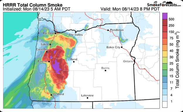
For today, we remain under a heat Advisory thru 8 PM tonight and a Red Flag Warning thru 11 PM tonight. Attached is this evening’s Smoke Forecast from the National Weather Service.

Slide Slide Slide Slide Slide Slide Slide Slide Subscribe Contribute

Ads

Featured Video

Tillamook Weather

Tides

Tillamook County Pioneer Podcast Series

Tillamook Church Search

Cloverdale Baptist Church
Nestucca Valley Presbyterian
Tillamook Ecumenical Service

Archives

  • Home
  • EULA Privacy Policy
  • Contact
  • Opt-out preferences
  • Search...
Share on facebook
Facebook
Share on pinterest
Pinterest
Share on twitter
Twitter
Share on linkedin
Linkedin
Catherine

Recent Posts

  • WHAT DOES FREEDOM MEAN TO YOU? Remember: Freedom

    July 2, 2025
  • TILLAMOOK'S JUNE DAIRY PARADE - JUNE 28, 2025 - Photo Slideshow & Video

    July 2, 2025
  • 142ND WING TO CONDUCT INDEPENDENCE DAY FLYOVERS - Manzanita, Rockaway Beach & Neskowin in Tillamook County

    July 2, 2025
©2025 | Theme by SuperbThemes

Manage Cookie Consent
To provide the best experiences, we use technologies like cookies to store and/or access device information. Consenting to these technologies will allow us to process data such as browsing behavior or unique IDs on this site. Not consenting or withdrawing consent, may adversely affect certain features and functions.
Functional Always active
The technical storage or access is strictly necessary for the legitimate purpose of enabling the use of a specific service explicitly requested by the subscriber or user, or for the sole purpose of carrying out the transmission of a communication over an electronic communications network.
Preferences
The technical storage or access is necessary for the legitimate purpose of storing preferences that are not requested by the subscriber or user.
Statistics
The technical storage or access that is used exclusively for statistical purposes. The technical storage or access that is used exclusively for anonymous statistical purposes. Without a subpoena, voluntary compliance on the part of your Internet Service Provider, or additional records from a third party, information stored or retrieved for this purpose alone cannot usually be used to identify you.
Marketing
The technical storage or access is required to create user profiles to send advertising, or to track the user on a website or across several websites for similar marketing purposes.
Manage options Manage services Manage {vendor_count} vendors Read more about these purposes
View preferences
{title} {title} {title}