Menu
  • Home
  • Feature
    • Breaking News
    • Arts
    • Astrology
    • Business
    • Community
    • Employment
    • Event Stories
    • From the Pioneer
    • Government
    • Letters to the Editor
    • Non Profit News
    • Obituary
    • Public Safety
    • Podcast Interview Articles
    • Pioneer Pulse Podcast: Politics, Palette, and Planet – the Playlist
  • Guest Column
    • Perspectives
    • Don Backman Photos
    • Ardent Gourmet
    • Kitchen Maven
    • I’ve been thinking
    • Jim Heffernan
    • The Littoral Life
    • Neal Lemery
    • View From Here
    • Virginia Carrell Prowell
    • Words of Wisdom
  • Weather
  • Post Submission
  • Things to do
    • Calendar
    • Tillamook County Parks
    • Tillamook County Hikes
    • Whale Watching
    • Tillamook County Library
    • SOS Community Calendar
  • About
    • Contribute
    • Advertise
    • Subscribe
    • Opt-out preferences
  • Search...
Menu

GORDON’S UPDATE: Weather 8/18/23 – Return to “Normal”, Hurricane in Forecast for Southern California Next Week

Posted on August 18, 2023 by Editor

By Gordon McCraw, Meteorologist for the Tillamook County Pioneer
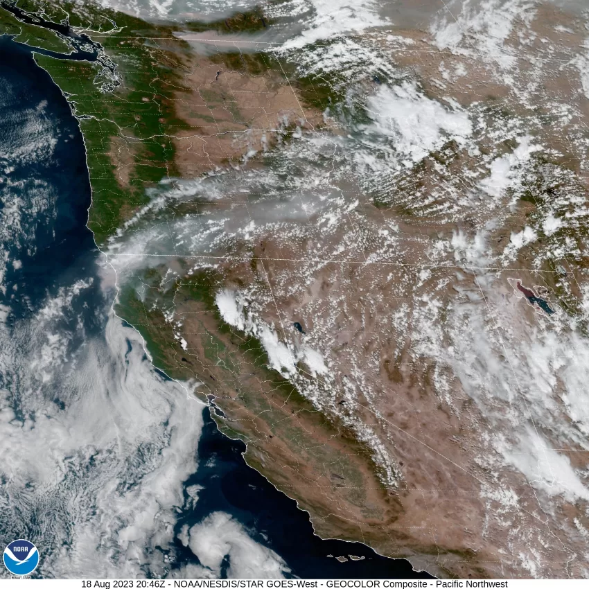
I am happy to report that the weather map has calmed down considerably. The only thing on the board is a Red Flag Warning for the areas east of the valley into the Cascades. The next weather event that will be taking over the headlines is a Hurricane in the Pacific that has a Tropical Storm Watch out for Southern California. This will play in the forecast for Oregon down the road.

Moving back to the local weather, all the heat related Watches and Warnings across the area have all been removed as the ridge responsible for all the records has weakened and we now see a trough of low pressure move down from the northwest that now rests off the coast. This is enhancing the onshore flow that is pushing in the cooler marine air that kept the temperatures here down to around 70 today. Tonight, we see mostly clear skies with the breezy winds easing later tonight, the lows down near 48.

We may see some patchy fog tomorrow morning, otherwise we are looking at another sunny day with the winds becoming westerly 15-20 gusting to 25, the high up around 74. Tomorrow night we will see some hazy skies, the winds again slowly ease under mostly clear skies, lows near 52.

A sunny, and warmer Sunday in store, along with the breezy afternoon winds becoming northwesterly 14-18 gusting to 30, the high near 76. Partly cloudy skies for Sunday night, again the winds ease late, lows near 52.

Next week our local weather takes a back seat to Hurricane Hilary that is now a Category 4 Hurricane with sustained winds 125 knots gusting to 145 knots. For us non-nautical types, that is around 144 mph sustained with gusts to 167 mph.

What we expect is for the hurricane to increase in speed next week, and weaken, impacting southern California as a Tropical Storm as it races northeastward. From here it is expected to move through Nevada into eastern Oregon. This could bring some impressive rainfall totals to our south and east next week, but for us, we go with partly to mostly sunny days, maybe some patchy morning fog possible, with highs in the upper 60s to low 70s, and some partly cloudy nights with lows in the low 50s, and this is good through at least Thursday.

Worth watching, having been a Hurricane County Forecaster in the past, I can tell you with certainty…that the path of this system is definitely not written in stone! The driver for this system is the upper level high pressure centered over the central U.S. Things in everyone’s favor are the large and tall mountains that will disrupt the flow but will also enhance the lift that drives the rain. The last time a Tropical Storm made landfall in California was in 1939, 84 years ago, so this is another “Once in a Lifetime” event that will be unfolding and will bring heavy, flooding rain to much of southern California.

Slide Slide Slide Slide Slide Slide Slide Slide Subscribe Contribute

Ads

Featured Video

Tillamook Weather

Tides

Tillamook County Pioneer Podcast Series

Tillamook Church Search

Cloverdale Baptist Church
Nestucca Valley Presbyterian
Tillamook Ecumenical Service

Archives

  • Home
  • EULA Privacy Policy
  • Contact
  • Opt-out preferences
  • Search...
Share on facebook
Facebook
Share on pinterest
Pinterest
Share on twitter
Twitter
Share on linkedin
Linkedin
Catherine

Recent Posts

  • ROCKAWAY BEACH READIES FOR JULY 4TH FESTIVITIES - HONORS VOLUNTEER OF YEAR & PARADE GRAND MARSHAL

    June 30, 2025
  • NEWS UPDATE FROM STATE REPRESENTATIVE DAVID GOMBERG: It's a Session Wrap!

    June 30, 2025
  • GORDON'S WEEKLY WEATHER UPDATE 6/30/25: Back to Normal Summer Weather This Week - Fair, Dry & Mild; Holiday Weekend Weather Looks Good

    June 30, 2025
©2025 | Theme by SuperbThemes

Manage Cookie Consent
To provide the best experiences, we use technologies like cookies to store and/or access device information. Consenting to these technologies will allow us to process data such as browsing behavior or unique IDs on this site. Not consenting or withdrawing consent, may adversely affect certain features and functions.
Functional Always active
The technical storage or access is strictly necessary for the legitimate purpose of enabling the use of a specific service explicitly requested by the subscriber or user, or for the sole purpose of carrying out the transmission of a communication over an electronic communications network.
Preferences
The technical storage or access is necessary for the legitimate purpose of storing preferences that are not requested by the subscriber or user.
Statistics
The technical storage or access that is used exclusively for statistical purposes. The technical storage or access that is used exclusively for anonymous statistical purposes. Without a subpoena, voluntary compliance on the part of your Internet Service Provider, or additional records from a third party, information stored or retrieved for this purpose alone cannot usually be used to identify you.
Marketing
The technical storage or access is required to create user profiles to send advertising, or to track the user on a website or across several websites for similar marketing purposes.
Manage options Manage services Manage {vendor_count} vendors Read more about these purposes
View preferences
{title} {title} {title}