Menu
  • Home
  • Feature
    • Breaking News
    • Arts
    • Astrology
    • Business
    • Community
    • Employment
    • Event Stories
    • From the Pioneer
    • Government
    • Letters to the Editor
    • Non Profit News
    • Obituary
    • Public Safety
    • Podcast Interview Articles
    • Pioneer Pulse Podcast: Politics, Palette, and Planet – the Playlist
  • Guest Column
    • Perspectives
    • Don Backman Photos
    • Ardent Gourmet
    • Kitchen Maven
    • I’ve been thinking
    • Jim Heffernan
    • The Littoral Life
    • Neal Lemery
    • View From Here
    • Virginia Carrell Prowell
    • Words of Wisdom
  • Weather
  • Post Submission
  • Things to do
    • Calendar
    • Tillamook County Parks
    • Tillamook County Hikes
    • Whale Watching
    • Tillamook County Library
    • SOS Community Calendar
  • About
    • Contribute
    • Advertise
    • Subscribe
    • Opt-out preferences
  • Search...
Menu

GORDON’S UPDATE: Weather 1/5/24 – Things are going to get interesting next week; Beach Hazard Warning Continues through the weekend

Posted on January 5, 2024January 6, 2024 by Editor

By Gordon McCraw, Meteorologist for the Tillamook County Pioneer

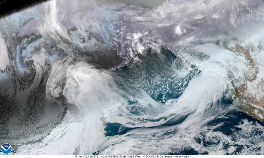
There were a few light showers moving across the area this morning that became more widely scattered by the afternoon. A quick look at the satellite picture though and we see a low pressure area moving into British Columbia with an associated front dropping south into Washington then westward into the Pacific. This front is expected to drop southward and push in more rain this evening with rain likely tonight. The front will slide through later tonight and this front has some cold, unstable air behind it so we will see some showers with a chance of some thunderstorms by around midnight. The southerly winds will be shifting to more northerly 5-10 around midnight also, and the low temperature tonight drops to near 38. It looks like we will be seeing snow in the higher Coast Range mountains by the early morning hours as the temperatures and snow level fall.

Tomorrow, we will see more showers and possible thunderstorms, and some of the heavier showers could produce small hail. We continue with the northerly winds 5-10 that do become more westerly later in the morning 5-10, the high only near 47, the snow level around 2500-2000’. It looks like more of the same tomorrow night, some showers with possible thunderstorms and a chance of small hail, the winds becoming northwesterly 10-15 gusting to 20, the low drops to 38 again, and the snow level is around 2300’.

Sunday a weak upper level ridge of high pressure will cause the showers to become more scattered and diminish the thunderstorm threat by around noon. The winds remain westerly 5-10, the high near 48. The showers become more widely scattered Sunday night, but then in comes some rain from the next approaching front late Sunday night, which is a warm front, and this pushes the snow level back up to near 2500’, the low again drops to near 38.

By Monday things are warming again, but still rainy and now breezy, the high near 53, the snow level pushes up above 3000’. Look for more warm rain Monday night, still breezy, the low only down to near 41.

On Tuesday, things start to get interesting as the associated cold front moves in, so we see more clouds, rain, and now some windy conditions, and the winds will be pushing in some colder air, so the temperatures fall, and so does the snow level, dropping to near 2400’ in the afternoon, the high near 49, we transition to showers with that thunderstorm threat in the unstable air again, the snow level drops to near 1800’ so it is likely the higher passes could see a rain/snow mix or some brief snow showers by later Tuesday night, the low down near 37.

Now Wednesday things get real interesting with questions about temperatures, and the snow level. It appears we have the potential to see an Arctic Airmass dropping down into the area. The questions not answered to clearly by the models is just how cold will we get, and with the rain still likely, just how low will the snow go. The model spreads are considerable. Some models actually warm things up some while other show things turning real cold with low level snow. For now, we will go with rainy and the snow level dropping down to at least the pass levels Wednesday night into Thursday. So if you plan to travel across any of the passes Wednesday night into Thursday, you will want to keep a close eye on the forecasts. Hopefully the models will come into better agreement by the start of next week.
LISTEN HERE:

Slide Slide Slide Slide Slide Slide Slide Slide Subscribe Contribute

Ads

Featured Video

Tillamook Weather

Tides

Tillamook County Pioneer Podcast Series

Tillamook Church Search

Cloverdale Baptist Church
Nestucca Valley Presbyterian
Tillamook Ecumenical Service

Archives

  • Home
  • EULA Privacy Policy
  • Contact
  • Opt-out preferences
  • Search...
Share on facebook
Facebook
Share on pinterest
Pinterest
Share on twitter
Twitter
Share on linkedin
Linkedin
Catherine

Recent Posts

  • TILLAMOOK COUNTY CREAMERY ASSOCIATION WORK-STUDY PROGRAM CREATES OPPORTUNITIES

    June 30, 2025
  • TILLAMOOK POLICE DEPARTMENT: Damascus Man Sentenced to 28 Years for Attempted Murder of Law Enforcement Officers in Tillamook County

    June 30, 2025
  • BOOK REVIEW: Abundance by Ezra Klein & Derek Thompson

    June 29, 2025
©2025 | Theme by SuperbThemes

Manage Cookie Consent
To provide the best experiences, we use technologies like cookies to store and/or access device information. Consenting to these technologies will allow us to process data such as browsing behavior or unique IDs on this site. Not consenting or withdrawing consent, may adversely affect certain features and functions.
Functional Always active
The technical storage or access is strictly necessary for the legitimate purpose of enabling the use of a specific service explicitly requested by the subscriber or user, or for the sole purpose of carrying out the transmission of a communication over an electronic communications network.
Preferences
The technical storage or access is necessary for the legitimate purpose of storing preferences that are not requested by the subscriber or user.
Statistics
The technical storage or access that is used exclusively for statistical purposes. The technical storage or access that is used exclusively for anonymous statistical purposes. Without a subpoena, voluntary compliance on the part of your Internet Service Provider, or additional records from a third party, information stored or retrieved for this purpose alone cannot usually be used to identify you.
Marketing
The technical storage or access is required to create user profiles to send advertising, or to track the user on a website or across several websites for similar marketing purposes.
Manage options Manage services Manage {vendor_count} vendors Read more about these purposes
View preferences
{title} {title} {title}