By Gordon McCraw, Meteorologist for the Tillamook County Pioneer
That pesky low pressure area continues to push northward along the coast towards Vancouver Island today, while rotating showers across the region. This also gave us breezy winds and a slight chance of thunderstorms today, especially along the coastal areas until the sun went down. Tonight, the activity eases, becoming more scattered as a high pressure ridge starts to build in, the winds becoming southeasterly 4-8, low temperatures down near 42.
Tomorrow, we see partly sunny skies with only a slight chance of any showers still, and even that diminishes later in the morning, winds becoming easterly 4-8, highs climbing to near 58. Tomorrow night is mostly cloudy but dry, light east winds still, lows near 42.
Friday is looking nice with a mostly sunny day, still the light east winds, the high climbs up to near 60, and with a mostly clear night, the low temperature Friday dips to near 41. Saturday is also mostly sunny, light winds, the highs near 57, but then by Saturday night we see a cold front, that had origins in the north Pacific, is approaching from the northwest and brings us some clouds and a chance of rain in the early morning hours, the low Saturday night around 41.
Sunday, into the start of next week, winter reminds us it isn’t done just yet. The rain likely moves in by late morning Sunday with that cold front. We see breezy conditions moving in also, the high only make it up to near 50. Then rainy Sunday night with the snow level dropping behind the front, likely dropping down past the summit levels, down to near 1000 to 1200’, still breezy, the low temperatures Sunday night down near 36. This means that around sunup Monday, we could see some lower levels getting a rain/snow mix, but accumulating snow looks to be above 1000’ which could see in excess of 6” of snow. We will need to watch the forecast though as there is about a 40% chance of seeing snow as low as 500’, and even a slight chance that the snow could be lower than 500’. Again, something to keep an eye on as any of this could change for the better, or worse, between now and then.
So, Monday is looking cloudy, rainy, and breezy with the snow level still around 1100’ which means the Hwy 6 summit will continue to be impacted into the afternoon when the temperature finally climbs above freezing for a few hours, the high here only up near 45 degrees. Monday night sees more rain with the snow level around 1300’ so more snow likely in the passes, on top of any ice from the snow that melted during the day, the overnight low temperature down here near 37 degrees but remember, with the breezy winds, the windchill temperatures will continue to make it feel more like 30 degrees.
Tuesday, we expect to be cloudy, rainy and breezy still, but the air continues to modify, and we see the snow level climbing to near 1700’ later that morning, up to near 2500’ in the afternoon, with the high temperature up near 49 degrees.
With the expected change in the weather, if you have business over in the valley Monday or Tuesday, it is best to keep up on the current and expected road and weather conditions going into the weekend as there is a chance that the roads on the other side of the hill are impacted anytime from Sunday night through Tuesday. If you were thinking of heading even further east, the Cascades are looking at somewhere between 1 to 2 feet of new snow, maybe more, from this event. A final caution, if you are planning to go camping, or some other fun thing in the higher Coast Range Mountains during this period, it is possible that the higher mountains could see in excess of a foot of new snow so know that you could get stuck there, lowering the fun on the fun-meter. Again, winter is not over yet!
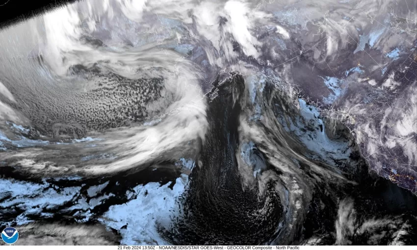
Just a quick look at the satellite picture and you can see the cold, cold front, with the many showers behind the front, that will impact us starting Sunday, that is just now passing the Aleutian Islands.
