Menu
  • Home
  • Feature
    • Breaking News
    • Arts
    • Astrology
    • Business
    • Community
    • Employment
    • Event Stories
    • From the Pioneer
    • Government
    • Letters to the Editor
    • Non Profit News
    • Obituary
    • Public Safety
    • Podcast Interview Articles
    • Pioneer Pulse Podcast: Politics, Palette, and Planet – the Playlist
  • Guest Column
    • Perspectives
    • Don Backman Photos
    • Ardent Gourmet
    • Kitchen Maven
    • I’ve been thinking
    • Jim Heffernan
    • The Littoral Life
    • Neal Lemery
    • View From Here
    • Virginia Carrell Prowell
    • Words of Wisdom
    • Chuck McLaughlin – 1928 to 2025
  • Weather
  • Post Submission
  • Things to do
    • Calendar
    • Tillamook County Parks
    • Tillamook County Hikes
    • Whale Watching
    • Tillamook County Library
    • SOS Community Calendar
  • About
    • Contribute
    • Advertise
    • Subscribe
    • Opt-out preferences
  • Search...
Menu

GORDON’S WEEKLY WEATHER UPDATE 8/25/25: More of the same … Low pressure area tmight bring some rain at end of week

Posted on August 25, 2025 by Editor

By Gordon McCraw, Meteorologist for the Tillamook County Pioneer

Well, it has definitely been on the warm side since the end of last week with the temperatures in the 70s and 80s at the coast, and the 90s and 100s over in the valley where they set some new record highs. The good news, for many, is the fact that the high pressure ridge that has been residing over the region is finally starting to weaken a little, and this combining with the upper level cloudiness moving across the area will help to moderate the temperatures some. We may also see some upper level smoke from the fires sweeping across to bring us some hazy skies the next couple of days. So, after a mostly sunny day today, the marine fog and clouds move in again tonight, and with calm winds, the overnight low is 55.

Tomorrow the clouds will burn back again, leaving a partly sunny day with the winds becoming westerly 5-10, the high near 70. Looks for increasing clouds tomorrow night with diminishing winds, the low near 56.

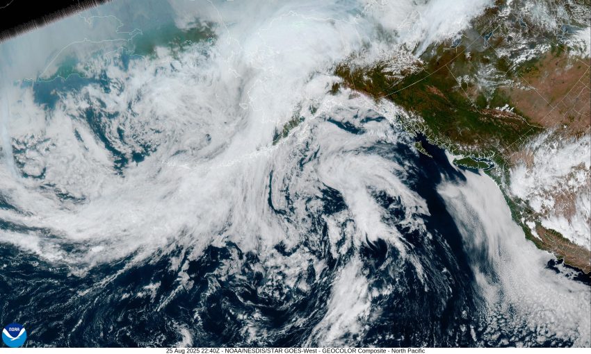
Wednesday, we see a low pressure area dropping southeastward from the Gulf of Alaska, west of British Columbia and this should increase our onshore flow which will aid in continuing to cool things down, so we see mostly sunny skies with westerly winds 4-8, the high near 70, then cloudy skies Wednesday night, the low near 56.

Thursday, we continue to watch that low pressure area in the Pacific dropping southward, off to our northwest. So we start out cloudy, but the mostly sunny skies return, the high near 71, and with increasing clouds again, the overnight low is around 55.

By Friday, things get a little more iffy. The problem is that low pressure area to the west will be competing against the high pressure ridge. At issue is, that low is expected to move eastward and possibly bring some rain across the area. However, the models show the low weakening as it nears and possibly gets pushed more to the north. This yields a forecast for Friday of mostly sunny skies by the afternoon, the highs still near 71, but we can add a slight chance of some light showers by around midnight, the low near 55.

We still have a slight chance of light showers during the day Saturday, the high near 71, then we dry out again by Saturday night, lows near 56.

For now, it looks like the fair, dry and mild conditions return for Sunday with partly sunny skies, the high near 72, lows near 56. Again though, this is all dependent on what that low pressure area does over the weekend.

So, hang in there folks, we are into the last week of August, then a few weeks later in September, Fall takes over.

And that’s it for now, we’ll see ya again next Monday.

Slide Slide Slide Slide Slide Slide Slide Slide Subscribe Contribute

Ads

Featured Video

Tillamook Weather

Tides

Tillamook County Pioneer Podcast Series

Tillamook Church Search

Cloverdale Baptist Church
Nestucca Valley Presbyterian
Tillamook Ecumenical Service

Archives

  • Home
  • EULA Privacy Policy
  • Contact
  • Opt-out preferences
  • Search...
Share on facebook
Facebook
Share on pinterest
Pinterest
Share on twitter
Twitter
Share on linkedin
Linkedin
Catherine

Recent Posts

  • GORDON'S WEEKLY WEATHER UPDATE 8/25/25: More of the same ... Low pressure area tmight bring some rain at end of week

    August 25, 2025
  • NESTUCCA VALLEY SCHOOL DISTRICT: SPECIAL MEETING, EXECUTIVE SESSION AUG. 26, 2025

    August 25, 2025
  • St. Peter Lutheran Church in Tillamook Announces Closing at Year End

    August 25, 2025
©2025 | Theme by SuperbThemes

Manage Cookie Consent
To provide the best experiences, we use technologies like cookies to store and/or access device information. Consenting to these technologies will allow us to process data such as browsing behavior or unique IDs on this site. Not consenting or withdrawing consent, may adversely affect certain features and functions.
Functional Always active
The technical storage or access is strictly necessary for the legitimate purpose of enabling the use of a specific service explicitly requested by the subscriber or user, or for the sole purpose of carrying out the transmission of a communication over an electronic communications network.
Preferences
The technical storage or access is necessary for the legitimate purpose of storing preferences that are not requested by the subscriber or user.
Statistics
The technical storage or access that is used exclusively for statistical purposes. The technical storage or access that is used exclusively for anonymous statistical purposes. Without a subpoena, voluntary compliance on the part of your Internet Service Provider, or additional records from a third party, information stored or retrieved for this purpose alone cannot usually be used to identify you.
Marketing
The technical storage or access is required to create user profiles to send advertising, or to track the user on a website or across several websites for similar marketing purposes.
Manage options Manage services Manage {vendor_count} vendors Read more about these purposes
View preferences
{title} {title} {title}