By Gordon McCraw, Meteorologist for the Tillamook County Pioneer
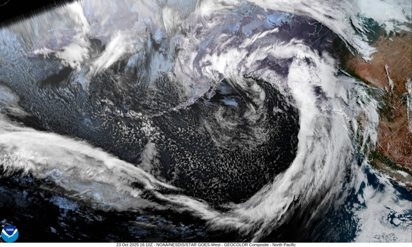
Hey there Tillamook, I thought I would give you an update on the pending bad weather. Yes, it looks like we are in for a very active and wet period that starts today then really gets active tomorrow, Friday through the weekend. The satellite picture clearly shows a deep low pressure trough with, what will become, a moderate atmospheric river that brings periods of heavy rain and strong winds, especially down at the beaches and headlands.
So, today we have the precursor to the stronger stuff, in the form of a weak front that is bringing us some rain that will transition to showers after midnight, the winds becoming southerly 10-15 gusting to 25 tonight with the low temperature down near 51. This first round will probably give us less than ¼” of rain. Down at the beach though, they could see southerly winds 20-25 increasing overnight to 25-30 gusting to 45-50.
Next in the series is a stronger cold front moving in from the Gulf of Alaska that will bring periods of moderate, occasionally heavy rain, strong winds, and cooler temperatures, as it transitions into a moderate Atmospheric River event tomorrow afternoon. This means that tomorrow you can expect showers with possible thunderstorms, with southerly winds 10-15 gusting to 30 to start, with about 1 to 2” of rain, then things ease some tomorrow night, including down at the beaches where the winds had been gusting to near 50 during the day, now maybe gusting to 40 to 45. Tomorrow night we likely see an additional inch or less of rain.
Saturday’s main event will be a low pressure area that develops off the coast of Washington and brings the area more showers with possible thunderstorms, the winds becoming southwesterly 20 to 25 gusting to 35 in the afternoon with the beaches seeing winds increase to 40 to 45, with gusts as high as 60 to 70. Saturday night, we continue to see showers with possible thunderstorms, the winds slowly ease by around midnight, becoming southwesterly 14-18 gusting to 25, then southerly 5-10 in the early morning hours. The beach winds decrease also, though still breezy with the winds becoming 25 to 35 then 20 to 30 in the early morning hours. The temperatures are also expected to cool with the afternoon high temperature only near 55, the overnight low near 43.
For Sunday, we continue to see showers with possible thunderstorms, not as breezy with westerly winds 15-20 gusting to 25, then with a zonal flow setting up, we will continue to see periods of rain through Monday into Tuesday. The long range models suggest we start to dry out the second half of next week.
So, as far as any flooding concern from the estimated 3 to 4” of rain we see here, from Friday through Sunday, and the 3.5 to 4.5 we see in the Coast Range, thanks to the rivers being pretty low right now, flooding concerns remain low. As is always the case during moderate to heavy rain periods though, Urban and Small Stream Flooding is a concern.
Lastly, I should mention that, as is always the case when we have these events triggered by a low pressure system, should the models be wrong on the lows intensity or path, conditions could be worse, or better. Either way, for now, I would anticipate areas with ponding water, and the usual power outages from downed trees. Make your plans now and be ready for whatever is thrown, or blown, at ya.
That’s it from me, keep an eye out for any additional Advisories, Watches or Warnings related to the event and I’ll be back Monday.