


Tillamook County Pioneer

News & People of Tillamook County. Every Day.

Menu
  • Home
  • Feature
    • Breaking News
    • Arts
    • Astrology
    • Business
    • Community
    • Employment
    • Event Stories
    • From the Pioneer
    • Government
    • Letters to the Editor
    • Non Profit News
    • Obituary
    • Public Safety
    • Podcast Interview Articles
    • Pioneer Pulse Podcast: Politics, Palette, and Planet – the Playlist
  • Guest Column
    • Perspectives
    • Don Backman Photos
    • Ardent Gourmet
    • Kitchen Maven
    • I’ve been thinking
    • Jim Heffernan
    • The Littoral Life
    • Neal Lemery
    • View From Here
    • Virginia Carrell Prowell
    • Words of Wisdom
    • Chuck McLaughlin – 1928 to 2025
  • Weather
  • Post Submission
  • Things to do
    • Calendar
    • Tillamook County Parks
    • Tillamook County Hikes
    • Whale Watching
    • Tillamook County Library
    • SOS Community Calendar
  • About
    • Contribute
    • Advertise
    • Subscribe
    • Opt-out preferences
  • Search...
Menu

GORDON’S WEEKLY WEATHER UPDATE 8/18/26: Summer continues with onshore flow; Sneaker wave warning through Wednesday; Slight chance of showers Saturday

Posted on August 18, 2026 by Editor


By Gordon McCraw, Meteorologist for the Tillamook County Pioneer

Better late than never … I had a minor family emergency yesterday as a family member broke a toe, as verified by a lengthy Urgent Care visit. Today, things are semi back to normal.

As far as the weather goes, with little change in the overall weather pattern, it looks like more of the same with the usual cloudy, foggy nights. The onshore flow continues, and the fog slowly burns back leaving fair skies later in the afternoon, along with mild temperatures. This leaves us with a forecast for tonight of increasing marine clouds, with the winds diminishing, and a low of 55.

Tomorrow starts out with the marine clouds and patchy morning fog that slowly burns back leaving a mostly sunny to sunny afternoon, the winds becoming northwesterly 4-8, tomorrow high temperature again near 68. Yep, the clouds and patchy fog return tomorrow night, the winds die of and the low back down to near 53.

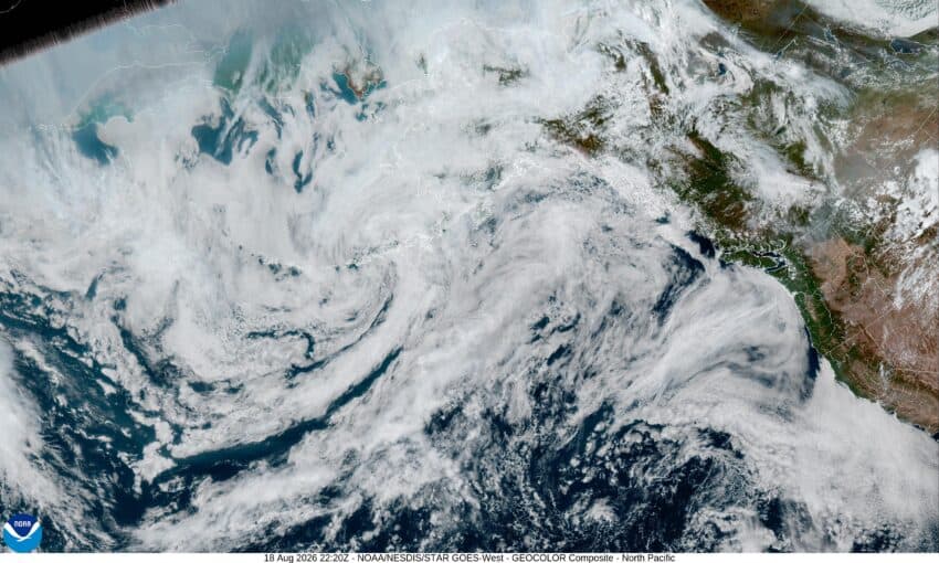
For Thursday, the large high pressure ridge over the Great Basin builds northwestward in response to a low pressure area west of northern California. This brings clearing mid to late morning, with the winds becoming westerly 4-8, the high up near 70. We see increasing clouds Thursday night, that are getting pushed up in the flow around that low pressure area west of northern California that is drifting to the northeast, some light winds, the low near 54.

Friday, we stay mostly cloudy as that low drifts closer to southwestern Oregon, the afternoon high temperature only up near 66, then mostly cloudy still Friday night, the low near 58.

Saturday the models show the low moving into Vancouver Island as the associated upper level trough of low pressure moves into coastal Oregon which does give us a slight chance of showers that morning, especially over the Coast Range, Saturday’s high temperature near 66. We keep the mostly cloudy skies Saturday night, the low near 53.

By Sunday it looks like a more zonal flow returns, so we return to a fair, dry, and mild pattern with partly sunny skies, the high near 69, partly cloudy skies for Sunday night, the low near 53.

Looking beyond the weekend, the long range models suggest little change in the pattern with the onshore flow dominating, though we will need to watch to see how far south a low pressure area and trough will make it next week. That forecast is too far out now to know if it would affect the Pacific Northwest, or if everything remains in southwestern Canada.

Lastly, I should mention, there is an increased sneaker wave threat tonight through Wednesday so, if you are near the surf, keep an extra eye out, and if you are in the water, be extra cautious as there is always a threat of rip currents in our area.

And that’s it, see yall again next week, stay safe everyone.

Please consider supporting the Pioneer with a contribution. Independent journalism stays alive on the Coast. Click here to contribute!

Ads

Keep the News Free to Read

Featured Video

Tillamook Weather

Tides

Tillamook Church Search

Cloverdale Baptist Church
Nestucca Valley Presbyterian
Tillamook Ecumenical Service

Tillamook County Pioneer Podcast Series

Archives

  • Home
  • EULA Privacy Policy
  • Contact
  • Opt-out preferences
  • Search...
Share on facebook
Facebook
Share on pinterest
Pinterest
Share on twitter
Twitter
Share on linkedin
Linkedin
Catherine

Recent Posts

  • TILLAMOOK COUNTY SHERIFF'S SEARCH & RESCUE BANQUET FUNDRAISER SEPT. 12TH - GET YOUR TICKETS NOW!

    August 18, 2026
  • GORDON'S WEEKLY WEATHER UPDATE 8/18/26: Summer continues with onshore flow; Sneaker wave warning through Wednesday; Slight chance of showers Saturday

    August 18, 2026
  • EFM announces acquisition of 29,000-Acre Nehalem Rainforest, Expanding Climate-Smart Forestry Portfolio on Oregon’s North Coast

    August 18, 2026
©2026 Tillamook County Pioneer | Theme by SuperbThemes
Manage Cookie Consent
To provide the best experiences, we use technologies like cookies to store and/or access device information. Consenting to these technologies will allow us to process data such as browsing behavior or unique IDs on this site. Not consenting or withdrawing consent, may adversely affect certain features and functions.
Functional Always active
The technical storage or access is strictly necessary for the legitimate purpose of enabling the use of a specific service explicitly requested by the subscriber or user, or for the sole purpose of carrying out the transmission of a communication over an electronic communications network.
Preferences
The technical storage or access is necessary for the legitimate purpose of storing preferences that are not requested by the subscriber or user.
Statistics
The technical storage or access that is used exclusively for statistical purposes. The technical storage or access that is used exclusively for anonymous statistical purposes. Without a subpoena, voluntary compliance on the part of your Internet Service Provider, or additional records from a third party, information stored or retrieved for this purpose alone cannot usually be used to identify you.
Marketing
The technical storage or access is required to create user profiles to send advertising, or to track the user on a website or across several websites for similar marketing purposes.
  • Manage options
  • Manage services
  • Manage {vendor_count} vendors
  • Read more about these purposes
View preferences
  • {title}
  • {title}
  • {title}