")
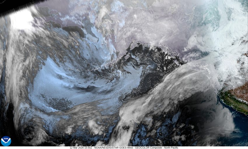

Thursday 3/12/26 @6:19AM – Tillamook County Emergency Management – ROAD CLOSURES
UPDATE 3/12/26 @10:20AM – Miami River Road is now OPEN, a couple of areas with standing water, use caution while driving. High water areas are signed.
Roads closed – Miami at MP1 due to flooding, Alderbrook Rd. by Posetti. High water outside lanes of 101 near the Fern in Tillamook. There are areas of high water on numerous roads, possibility of debris on the roadway. Drive with CAUTION.
Debris/Rock Slide 3/12/26 – Hwy. 101 between Garibaldi and Rockaway – use caution in the area.
By Gordon McCraw, Meteorologist for the Tillamook County Pioneer
Wednesday, March 11, 2026 @ 9pm
Well, obviously that atmosphere river is expected to give us a greater impact than we previously expected. As I write this, this Wednesday evening, Tillamook has gotten a little over 2” of rain and the Coast Range is at just under 5” today. This is rapidly pushing up the river levels, and now the Wilson and the Trask Rivers are forecasted to reach Minor Flood Stage between midnight through early tomorrow morning. Even the Nehalem River is looking at getting near bankfull late tonight or early tomorrow morning. Of course, this is based on the atmospheric river doing what was forecasted. If it lingers over our area longer, then the river levels could be higher, but if it drifts further south, or oscillates to the north, then it won’t be as bad. As a result of all this, the National Weather Service Portland has issued a Flood Watch for the Wilson and Trask Rivers from late tonight through early Saturday. For those of us that have been through a flood or two, we know the tides play an important role in the flooding time and duration also. So, having said that, the next high tide is around 7am tomorrow morning, then another at around 10pm tomorrow night. High tides hamper the outflow of water from the rivers as it nears the bay.
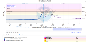
Here is the Wilson River gauge readings 3/12/26 at 7:30AM:
So, continued rainy, and it could be heavy at time, the winds southwesterly 20-25 gusting to 40, the low tonight near 41, then the rain continues today, Thursday, maybe not as heavy, the winds ease, highs near 50, still rainy tomorrow night, the low near 45.
Now, we stay rainy Friday, but it also turns cooler, the high near 52, but then while we stay rainy Friday night, the winds southwesterly 4-8, the low drops to near 37. This means the Coast Range Passes could be looking at some snow.
The rain eases some more Saturday with a ridge building in leaving only a chance of rain later Saturday into Sunday. This means the start of next week we could be seeing highs in the 60s, with the lows in the upper 40s, still with that chance of rain though.
Again, all this is assuming the atmospheric river does what the models are currently suggesting.