Menu
  • Home
  • Breaking News
  • Feature
    • Arts
    • Astrology
    • Business
    • Community
    • Employment
    • Event Stories
    • From the Pioneer
    • Government
    • Letters to the Editor
    • Non Profit News
    • Obituary
    • Public Safety
    • Podcast Interview Articles
    • Pioneer Pulse Podcast: Politics, Palette, and Planet – the Playlist
  • Weather
  • Guest Column
    • Perspectives
    • Don Backman Photos
    • Ardent Gourmet
    • Kitchen Maven
    • I’ve been thinking
    • Jim Heffernan
    • The Littoral Life
    • Neal Lemery
    • View From Here
    • Virginia Carrell Prowell
    • Words of Wisdom
  • Things to do
    • Calendar
    • Tillamook County Parks
    • Tillamook County Hikes
    • Whale Watching
    • Tillamook County Library
    • SOS Community Calendar
  • About
    • Contribute
    • Advertise
    • Subscribe
    • Opt-out preferences
  • Post Submission Test
  • Search...
Menu

GAM Weather: Tillamook Area Forecast – Friday, January 3, 2020, 09:15am

Posted on January 3, 2020 by Editor


By Gordon McCraw, GAM Weather
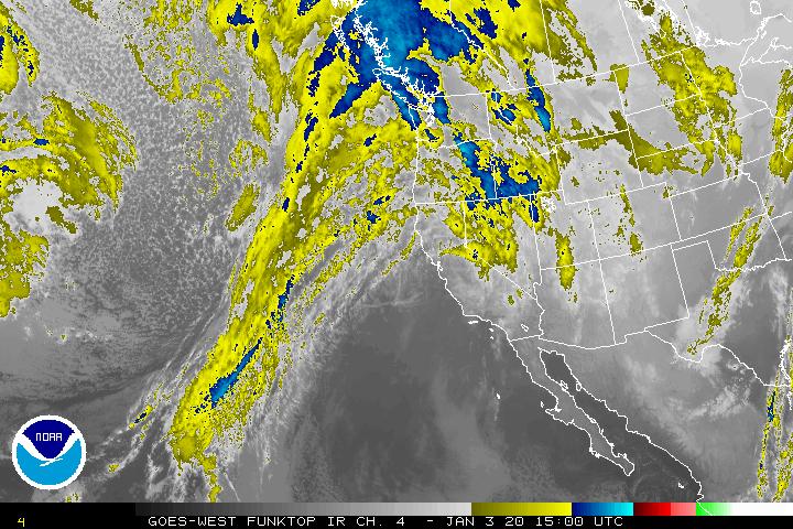
We appear to be in the calm before the storm. A look at the satellite picture shows a stronger cold front off to the west advancing towards the coast. This approaching front will cause the clouds and winds to increase today with maybe some light to moderate rain starting this afternoon. The winds becoming southerly 15-20 gusting to 30-35, 40-45 at the beaches and headlands.
The associated moderate to heavy rain will start around sunset today, continuing until the front finally pushes through around midnight tonight. The winds will also increase tonight, becoming southwesterly 15-25 gusting to 45 in town, with gusts to 50-60 possible at the beaches. It appears we could see between 1 and 2″ of rain for this 24 hour period with the Coast Range getting the higher amounts as usual. The rivers continue to not be a flooding concern.

The front should push through late tonight, approaching midnight, but leaving scattered showers with possible thunderstorms through the early morning hours. Winds will also decrease but still be on the breezy side, westerly 15-20 gusting to 30. Highs today near 55, lows tonight near 42.
The showers persist through tomorrow, January 4th, though they will be decreasing, except over the Coast Range. Tomorrow night the rain returns with the next front around midnight and persist though the day on Sunday. This will also bring back the breezy conditions with winds becoming southerly 14-18 gusting to 30. The temperature also cool a bit with highs now only up to around 48, lows down near 41.

Rainy and breezy during the day Sunday, January 5th, winds southwesterly 14-18 gusting to 25, back over to scattered showers Sunday night, and the snow level drops down to around 2500”, so, accumulating snow possible in the higher Coast Range Mountains Sunday. The shower activity becomes more widely scattered early Monday morning but another front pushes in more rain later Monday morning followed by another front on Tuesday then scattered showers expected for Wednesday, highs near 50, lows near 40. The active winter pattern continues!
​
​​Gordon
GAM Weather
Your Pacific Northwest Weather Authority

​

Featured Video

Slide Contribute SUBSCRIBE

Tillamook Weather

Tides

Tillamook County Pioneer Podcast Series

Tillamook Church Search

Cloverdale Baptist Church
Nestucca Valley Presbyterian
Tillamook Ecumenical Service

Archives

  • Home
  • EULA Privacy Policy
  • Contact
  • Opt-out preferences
  • Search...
Share on facebook
Facebook
Share on pinterest
Pinterest
Share on twitter
Twitter
Share on linkedin
Linkedin
Catherine

Recent Posts

  • OBITUARY: Paul Floyd Dillenburg - May 27, 1963 - May 6, 2025

    May 8, 2025
  • May is Mental Health Awareness Month: Taking the First Step Toward Wellness

    May 7, 2025
  • In Favor of the Proposed TLT Increase–A Vote for County Measure 29-183 is a Vote for County Workers

    May 7, 2025
©2025 | Theme by SuperbThemes

Manage Cookie Consent
To provide the best experiences, we use technologies like cookies to store and/or access device information. Consenting to these technologies will allow us to process data such as browsing behavior or unique IDs on this site. Not consenting or withdrawing consent, may adversely affect certain features and functions.
Functional Always active
The technical storage or access is strictly necessary for the legitimate purpose of enabling the use of a specific service explicitly requested by the subscriber or user, or for the sole purpose of carrying out the transmission of a communication over an electronic communications network.
Preferences
The technical storage or access is necessary for the legitimate purpose of storing preferences that are not requested by the subscriber or user.
Statistics
The technical storage or access that is used exclusively for statistical purposes. The technical storage or access that is used exclusively for anonymous statistical purposes. Without a subpoena, voluntary compliance on the part of your Internet Service Provider, or additional records from a third party, information stored or retrieved for this purpose alone cannot usually be used to identify you.
Marketing
The technical storage or access is required to create user profiles to send advertising, or to track the user on a website or across several websites for similar marketing purposes.
Manage options Manage services Manage {vendor_count} vendors Read more about these purposes
View preferences
{title} {title} {title}