")

By Gordon McCraw, Meteorologist for the Tillamook County Pioneer
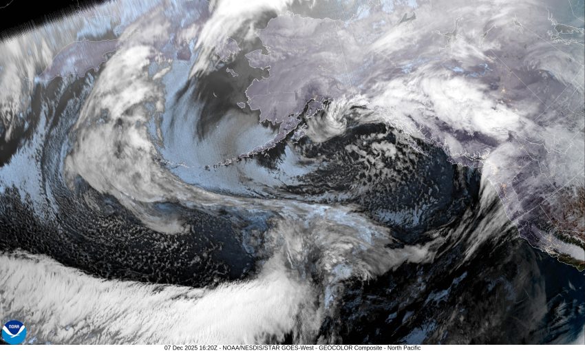
The latest models are suggesting the hose from these Atmosphere Rivers (AR) will be aimed more towards Tillamook. Just looking at the satellite picture shows a warm, very moisture rich area in the Pacific rushing eastward and the models show it bringing moderate and heavy rain into the coast by Tuesday night. Before that we can expect the first of the systems to push in rain with some breezy conditions today with gusts to 25-30 expected in town with higher gusts at the beaches. The rain continues tonight Sunday, though the winds are not as strong and the rainfall numbers for the day range between ½” to 1”.
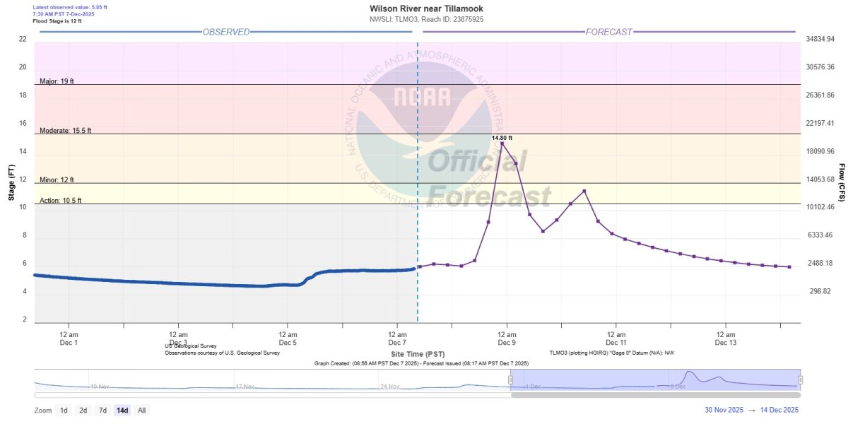
Tomorrow, Monday, the heavier, or AR #1, will bring in moderate, occasionally heavy rain into the area with increasing southerly winds 20-25 gusting to 40, and this heavier rain and gusty winds persist into Monday night. Rainfall totals for Monday range from 4” to 6” with up to 7” possible in the Coast Range. I will focus on the Wilson River as this is the one that will present the biggest problems. The current River Forecast has the flows rates rapidly increasing by Monday afternoon, reaching Minor Flood Stage that evening and cresting right at Moderate Flood Stage that night, before falling back to near Action Stage in the early morning hours Tuesday. This forecast was issued at 1:45pm yesterday. This was before the overnight models came out so I would expect these forecasted levels to possibly increase on the next River Model Run today and you can expect with more frequent updates, the levels will fluctuate up and down with each update.
Tuesday night brings AR #2. We can expect some light to moderate rain during the day Tuesday that allows the rivers to recede some, but in comes another round of moderate to heavy rain Tuesday night, along with the breezy conditions again, similar to Monday. For now, it looks like the area will see another 3-5”, with up to 7” again possible in the Coast Range. This should again increase the river flow rate. I would keep a close eye on the next River Forecast to see the trends on surge number two from Tuesday night into Wednesday.
Things start to mellow out Thursday with a chance of rain remaining through the weekend.
Currently there is a Flood Watch for pretty much the entire Portland NWS forecasting area. There is also a Flood Warning already issued for the Wilson River effective from Monday evening out Until Further Notice. This Warning states there is a 75% chance of the river reaching Moderate Flood Stage and a 55% chance of it reaching Major Flood Stage. Given this, I suggest looking at the next River Forecast outputs later this morning. I recommend that later today, and definitely no later than tomorrow morning, all preparedness actions should be taken, especially in the North Main areas of Tillamook, with the assumption that this will be a Flooding Event that will impact Hwy 101 from Hoquarton Slough northward to near Fred Meyer and the Creamery. If the levels rise sufficiently, then even the Wilson River Loop will be impacted. This means that homes at Makinster Rd and Goodspeed Roads could see flooding as well. This has the potential to be the most significant event we have seen for a couple of years. I say this because some of the models show the worst-case scenario of the river reaching Major Flood Stage, what is presented here is the most likely outcome. If the rivers do flood above 16’, then there is the potential that the North Main areas will be closed from late Tuesday evening into Thursday. Know that the Misty River RV park east of Tillamook on Hwy 6 and the Tillamook Coast RV Park near Netarts Hwy could also be impacted. Know that the high tide periods only aggravate the flooding issues.
There is also a chance of several areas in the county could see Urban and Small Stream Flooding during prolonged periods of heavy rainfall.
So, keep a close eye on the forecasts for the next couple of days, know that there could be flooding, landslides and power outages with trees down in some areas, which is typical for these types of event. I will update the Pioneer again in the morning so stay tuned!