Menu
  • Home
  • Feature
    • Breaking News
    • Arts
    • Astrology
    • Business
    • Community
    • Employment
    • Event Stories
    • From the Pioneer
    • Government
    • Letters to the Editor
    • Non Profit News
    • Obituary
    • Public Safety
    • Podcast Interview Articles
    • Pioneer Pulse Podcast: Politics, Palette, and Planet – the Playlist
  • Guest Column
    • Perspectives
    • Don Backman Photos
    • Ardent Gourmet
    • Kitchen Maven
    • I’ve been thinking
    • Jim Heffernan
    • The Littoral Life
    • Neal Lemery
    • View From Here
    • Virginia Carrell Prowell
    • Words of Wisdom
  • Weather
  • Post Submission
  • Things to do
    • Calendar
    • Tillamook County Parks
    • Tillamook County Hikes
    • Whale Watching
    • Tillamook County Library
    • SOS Community Calendar
  • About
    • Contribute
    • Advertise
    • Subscribe
    • Opt-out preferences
  • Search...
Menu

GORDON’S UPDATE: Weather 11/2/23 – Rain & wind, showers, then repeat …

Posted on November 2, 2023November 2, 2023 by Editor

By Gordon McCraw, Meteorologist for the Tillamook County Pioneer

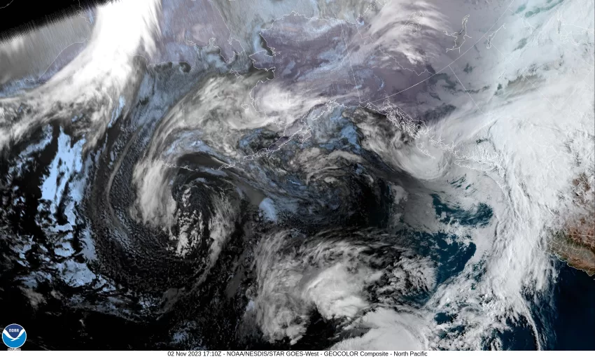
The atmospheric river and front pushed through early this morning leaving some patchy light rain. It was windy though with winds at the airport gusting to 35 and the winds at the beaches gusting into the 40s with peak gusts near 56 in Pacific City. The good news is it appears the heavier rain ended up moving into Washington. So tonight, we are just looking at scattered, mainly light, showers with the winds decreasing and becoming light and variable, the low drops to near 47.

Tomorrow looks cloudy, but we have another faster moving atmospheric river approaching so we have an increasing chance of rain starting tomorrow afternoon with light easterly winds, the high near 63. The rain and winds will increase tomorrow night, winds becoming southerly 8-12 gusting to 20, lows near 53. It appears we will see another 1” to 2” of rain from this system though there may be some Coast Range areas that see 2-4”.

The rain continues into Saturday morning then transitions to showers by the afternoon but becoming windy with southerly winds 18-24 gusting to 35, highs near 62. We can expect more showers Saturday night, with a chance of thunderstorms, still the breezy winds that will be easing and becoming southerly 8-12 by around midnight, lows near 49.

On Sunday a cooler upper level trough of low pressure moves in and brings us more rain with breezy conditions, along with a chance of thunderstorms, and this weather persists into Monday including Monday night, highs near 57, lows near 47.

Then cooler, showery weather continues Tuesday and Wednesday with daytime highs around 56, nighttime lows around 45.

Because these atmospheric river events are faster moving with breaks in the rain between the systems, and the hose on this first system was pointed more to our north, river levels do increase but not to a level causing any flooding concerns. The only coastal river that even appears to reach Action Stage is the usual, Grays River in Washington.

Slide Slide Slide Slide Slide Slide Slide Slide Subscribe Contribute

Ads

Featured Video

Tillamook Weather

Tides

Tillamook County Pioneer Podcast Series

Tillamook Church Search

Cloverdale Baptist Church
Nestucca Valley Presbyterian
Tillamook Ecumenical Service

Archives

  • Home
  • EULA Privacy Policy
  • Contact
  • Opt-out preferences
  • Search...
Share on facebook
Facebook
Share on pinterest
Pinterest
Share on twitter
Twitter
Share on linkedin
Linkedin
Catherine

Recent Posts

  • ROCKAWAY BEACH READIES FOR JULY 4TH FESTIVITIES - HONORS VOLUNTEER OF YEAR & PARADE GRAND MARSHAL

    June 30, 2025
  • NEWS UPDATE FROM STATE REPRESENTATIVE DAVID GOMBERG: It's a Session Wrap!

    June 30, 2025
  • GORDON'S WEEKLY WEATHER UPDATE 6/30/25: Back to Normal Summer Weather This Week - Fair, Dry & Mild; Holiday Weekend Weather Looks Good

    June 30, 2025
©2025 | Theme by SuperbThemes

Manage Cookie Consent
To provide the best experiences, we use technologies like cookies to store and/or access device information. Consenting to these technologies will allow us to process data such as browsing behavior or unique IDs on this site. Not consenting or withdrawing consent, may adversely affect certain features and functions.
Functional Always active
The technical storage or access is strictly necessary for the legitimate purpose of enabling the use of a specific service explicitly requested by the subscriber or user, or for the sole purpose of carrying out the transmission of a communication over an electronic communications network.
Preferences
The technical storage or access is necessary for the legitimate purpose of storing preferences that are not requested by the subscriber or user.
Statistics
The technical storage or access that is used exclusively for statistical purposes. The technical storage or access that is used exclusively for anonymous statistical purposes. Without a subpoena, voluntary compliance on the part of your Internet Service Provider, or additional records from a third party, information stored or retrieved for this purpose alone cannot usually be used to identify you.
Marketing
The technical storage or access is required to create user profiles to send advertising, or to track the user on a website or across several websites for similar marketing purposes.
Manage options Manage services Manage {vendor_count} vendors Read more about these purposes
View preferences
{title} {title} {title}