Menu
  • Home
  • Breaking News
  • Feature
    • Arts
    • Astrology
    • Business
    • Community
    • Employment
    • Event Stories
    • From the Pioneer
    • Government
    • Letters to the Editor
    • Non Profit News
    • Obituary
    • Public Safety
    • Podcast Interview Articles
    • Pioneer Pulse Podcast: Politics, Palette, and Planet – the Playlist
  • Weather
  • Guest Column
    • Perspectives
    • Don Backman Photos
    • Ardent Gourmet
    • Kitchen Maven
    • I’ve been thinking
    • Jim Heffernan
    • The Littoral Life
    • Neal Lemery
    • View From Here
    • Virginia Carrell Prowell
    • Words of Wisdom
  • Things to do
    • Calendar
    • Tillamook County Parks
    • Tillamook County Hikes
    • Whale Watching
    • Tillamook County Library
    • SOS Community Calendar
  • About
    • Contribute
    • Advertise
    • Subscribe
    • Opt-out preferences
  • Post Submission Test
  • Search...
Menu

GORDON’S UPDATE: Weather 2/10/23; Seasonal Temps & Precipitation for Feb. – April

Posted on February 10, 2023February 12, 2023 by Editor

By Gordon McCraw, Meteorologist for the Tillamook County Pioneer

Friday, February 10, 2023

A look at the satellite this morning showed a trough along the coast with a low pressure area moving ashore just north of Vancouver Island and another headed into Northern California. This pushed a front thru our area that gave us about ½” of rain.  We saw a few scattered light showers today that have become more widely scattered this evening and will continue to diminish overnight.  The winds tonight becoming northerly 5-10, lows tonight down near 36, the snow level about 2300’.

Tomorrow we have a high pressure ridge building in again, so we can expect a mostly sunny, dry day with the winds becoming northwesterly 5-10 in the afternoon, highs near 50. Still partly cloudy tomorrow night with relatively light easterly winds, the lows near 35.

Sunday starts out partly sunny and dry but we see another trough of low pressure moving down from the northwest that will push in some clouds that afternoon, then we develop an increasing chance of rain that evening, still the light winds during the day, the high near 53. The rain is likely by Sunday night, lows near 39.

Monday a cold front moves thru early in the morning bringing more rain and winds, then by sunrise transitions to showers. We still see some breezy winds that will be pulling in some colder air so the high only climbs to near 46 as the snow level drops to near 1700’. Monday night we are still cloudy and breezy with showers and the snow level plummets to near 700’ with the overnight low near 33.  This means we could see a rain/snow mix at times in the heavier showers, or maybe even a trace of low level snow if the temperature drops more.  It also means the Coast Range will see accumulating snow across the passes, especially above 1000’.

If you have to travel over to Portland, or maybe even across Cascade Head or north by Neahkahnie Mountain, you will want to look at tripcheck.com and weather.gov/Portland before you go to check on road conditions. The snow level will climb to near 1000’ Tuesday but with scattered showers still in the area, more snow is possible in the higher elevation passes.  Highs Tuesday around 45 then drops to near 30 Tuesday night.  Fortunately, the shower activity will have diminished considerably Tuesday night into Wednesday morning.

Speaking of Wednesday, it looks like a ridge will be building in which will help to push the snow level back up to around 1700’ by the afternoon with a high near 48. As it looks like a flat ridge we can still have a disturbance sneak across the ridge so we continue with a slight chance of showers thru Wednesday night into Thursday, highs near 49, lows near 34, and the snow level likely above 2000’.

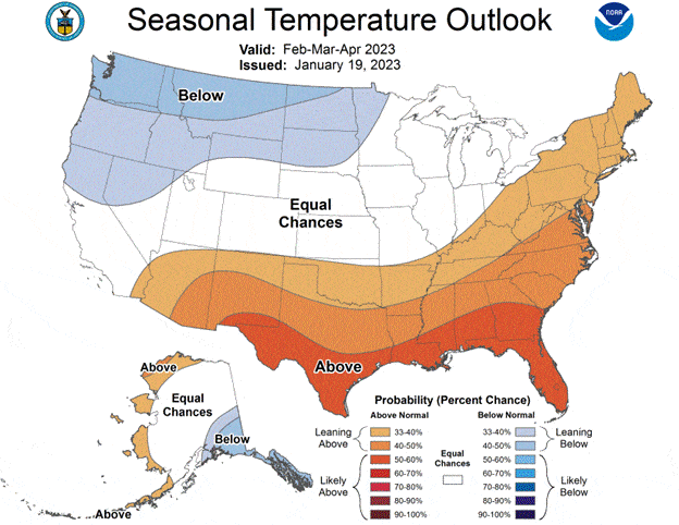
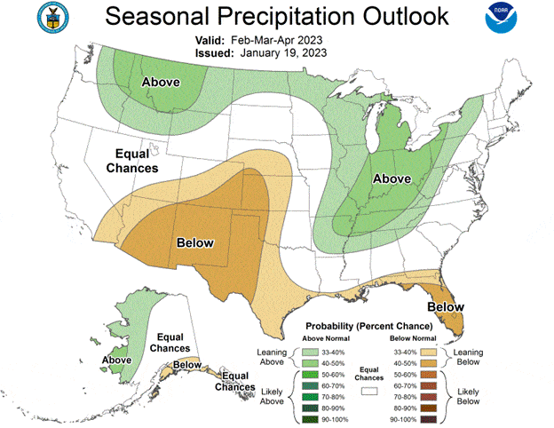
Long Range Outlook, February thru April

Just in case you were wondering, here is the last Seasonal Precipitation and Temperature outlooks from the NWS Climate Prediction Center.  They show that it is expected that we have an equal chance of above or below normal precipitation for the period thru April, and we are leaning below normal for temperatures in that period.  In other words, they suggest we will have average rain chances but are leaning towards cooler than normal temperatures.


Featured Video

Slide Contribute SUBSCRIBE

Tillamook Weather

Tides

Tillamook County Pioneer Podcast Series

Tillamook Church Search

Cloverdale Baptist Church
Nestucca Valley Presbyterian
Tillamook Ecumenical Service

Archives

  • Home
  • EULA Privacy Policy
  • Contact
  • Opt-out preferences
  • Search...
Share on facebook
Facebook
Share on pinterest
Pinterest
Share on twitter
Twitter
Share on linkedin
Linkedin
Catherine

Recent Posts

  • NEWS UPDATE FROM STATE REPRESENTATIVE DAVID GOMBERG: The Final Third

    May 13, 2025
  • Tillamook People's Utility District REGULAR MEETING NOTICE May 27, 2025 in Rockaway Beach

    May 13, 2025
  • Tillamook FFA Excels in State Career Development Events: Two Teams Headed to Nationals

    May 12, 2025
©2025 | Theme by SuperbThemes

Manage Cookie Consent
To provide the best experiences, we use technologies like cookies to store and/or access device information. Consenting to these technologies will allow us to process data such as browsing behavior or unique IDs on this site. Not consenting or withdrawing consent, may adversely affect certain features and functions.
Functional Always active
The technical storage or access is strictly necessary for the legitimate purpose of enabling the use of a specific service explicitly requested by the subscriber or user, or for the sole purpose of carrying out the transmission of a communication over an electronic communications network.
Preferences
The technical storage or access is necessary for the legitimate purpose of storing preferences that are not requested by the subscriber or user.
Statistics
The technical storage or access that is used exclusively for statistical purposes. The technical storage or access that is used exclusively for anonymous statistical purposes. Without a subpoena, voluntary compliance on the part of your Internet Service Provider, or additional records from a third party, information stored or retrieved for this purpose alone cannot usually be used to identify you.
Marketing
The technical storage or access is required to create user profiles to send advertising, or to track the user on a website or across several websites for similar marketing purposes.
Manage options Manage services Manage {vendor_count} vendors Read more about these purposes
View preferences
{title} {title} {title}