Menu
  • Home
  • Feature
    • Breaking News
    • Arts
    • Astrology
    • Business
    • Community
    • Employment
    • Event Stories
    • From the Pioneer
    • Government
    • Letters to the Editor
    • Non Profit News
    • Obituary
    • Public Safety
    • Podcast Interview Articles
    • Pioneer Pulse Podcast: Politics, Palette, and Planet – the Playlist
  • Guest Column
    • Perspectives
    • Don Backman Photos
    • Ardent Gourmet
    • Kitchen Maven
    • I’ve been thinking
    • Jim Heffernan
    • The Littoral Life
    • Neal Lemery
    • View From Here
    • Virginia Carrell Prowell
    • Words of Wisdom
  • Weather
  • Post Submission
  • Things to do
    • Calendar
    • Tillamook County Parks
    • Tillamook County Hikes
    • Whale Watching
    • Tillamook County Library
    • SOS Community Calendar
  • About
    • Contribute
    • Advertise
    • Subscribe
    • Opt-out preferences
  • Search...
Menu

GORDON’S UPDATE: Weather 2/12/24 – Rain, Snow, Freezing Rain?

Posted on February 12, 2024February 12, 2024 by Editor

LISTEN HERE:

By Gordon McCraw, Meteorologist for the Tillamook County Pioneer

Well, a weak low pressure area moved across to our north this morning with most of the showers pushing across extreme northern Oregon and into Washington, though a few light showers were still affecting our area this morning. As that low continues to weaken and move eastward, high pressure starts to build in and that will help to dry things out this afternoon and evening. The problem is, with increasing breaks in the clouds tonight, along with some light winds, radiational cooling will drop the temperatures down to near 36 degrees, which would be down near the dew point, and that equals a chance of patchy fog, and at that temperature you could see some frost as well after around midnight.

So tomorrow starts out with that patchy fog and frost that will quickly burn off after sunrise and we see warming temperatures under the mostly sunny skies. Winds tomorrow becoming westerly 4-8, with a high near 53. But alas, tomorrow night we watch an area of rain moving up from the southwest, so we see increasing clouds with easterly winds 5-10, the low drops to near 37, but then we see a slight chance of rain moving in by the early morning hours. This could lead to some icy roads across the top of summits in the early morning hours until the temperatures warm up to above freezing with a warmer system pushing in. The forecasts for the summit at Hwy 6 is for rain, with a chance of snow, or freezing rain, or all three.

Wednesday is looking cloudy and rainy with that subtropical moisture pushing in, easterly winds 10-15 gusting to 20, the high only near 50. Wednesday night is no better, still cloudy, and rainy, with the breezy winds that are becoming more southerly, but with the clouds and that southerly wind, the temperature only drops to near 43. The summit forecast is for rain with a chance of snow, the freezing level up around 2000’.

The moderate rain and breezy winds with the atmospheric river continue Thursday, the high up near 51. We continue to see a chance of rain Thursday night, the low down near 41. Obviously, with the possible 1-2” of rain expected in our area from this event, and the 2-3” possible in the Coast Range, we do see the rivers react to all the rain, but river flooding concern remains low though as always during periods of heavier rain, Urban and Small Stream Flooding is possible.

We still have a chance of rain on Friday, and we’re still on the breezy side, highs near 53, lows near 42. As for the rest of the weekend, it’s looking like another system will bring in more rain Saturday and Sunday then we watch a low pressure area, that will likely be west of northern California, that could send some wrap-around moisture into our area for the start of next week.

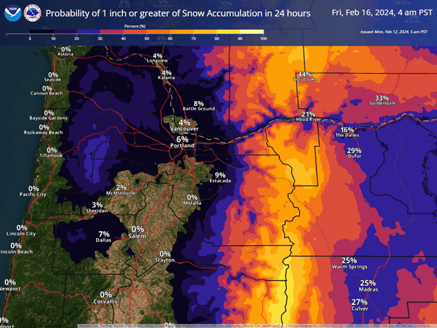
Just an FYI, you will be hearing about a chance of low elevation snow. Some of the models are giving a chance of snow in the Portland area Wednesday and Thursday. The snow chance for our area will again be isolated to the Coast Range, down to possibly the summit levels. The best chances are seen east of Portland in the Gorge and Hood River areas with heavy snow possible in the Cascades, especially north of Mt. Hood.

Slide Slide Slide Slide Slide Slide Slide Slide Subscribe Contribute

Ads

Featured Video

Tillamook Weather

Tides

Tillamook County Pioneer Podcast Series

Tillamook Church Search

Cloverdale Baptist Church
Nestucca Valley Presbyterian
Tillamook Ecumenical Service

Archives

  • Home
  • EULA Privacy Policy
  • Contact
  • Opt-out preferences
  • Search...
Share on facebook
Facebook
Share on pinterest
Pinterest
Share on twitter
Twitter
Share on linkedin
Linkedin
Catherine

Recent Posts

  • TILLAMOOK PEOPLE’S UTILITY DISTRICT: July 2025 Meetings

    July 1, 2025
  • ROCKAWAY BEACH READIES FOR JULY 4TH FESTIVITIES - HONORS VOLUNTEER OF YEAR & PARADE GRAND MARSHAL

    June 30, 2025
  • NEWS UPDATE FROM STATE REPRESENTATIVE DAVID GOMBERG: It's a Session Wrap!

    June 30, 2025
©2025 | Theme by SuperbThemes

Manage Cookie Consent
To provide the best experiences, we use technologies like cookies to store and/or access device information. Consenting to these technologies will allow us to process data such as browsing behavior or unique IDs on this site. Not consenting or withdrawing consent, may adversely affect certain features and functions.
Functional Always active
The technical storage or access is strictly necessary for the legitimate purpose of enabling the use of a specific service explicitly requested by the subscriber or user, or for the sole purpose of carrying out the transmission of a communication over an electronic communications network.
Preferences
The technical storage or access is necessary for the legitimate purpose of storing preferences that are not requested by the subscriber or user.
Statistics
The technical storage or access that is used exclusively for statistical purposes. The technical storage or access that is used exclusively for anonymous statistical purposes. Without a subpoena, voluntary compliance on the part of your Internet Service Provider, or additional records from a third party, information stored or retrieved for this purpose alone cannot usually be used to identify you.
Marketing
The technical storage or access is required to create user profiles to send advertising, or to track the user on a website or across several websites for similar marketing purposes.
Manage options Manage services Manage {vendor_count} vendors Read more about these purposes
View preferences
{title} {title} {title}