Menu
  • Home
  • Feature
    • Breaking News
    • Arts
    • Astrology
    • Business
    • Community
    • Employment
    • Event Stories
    • From the Pioneer
    • Government
    • Letters to the Editor
    • Non Profit News
    • Obituary
    • Public Safety
    • Podcast Interview Articles
    • Pioneer Pulse Podcast: Politics, Palette, and Planet – the Playlist
  • Guest Column
    • Perspectives
    • Don Backman Photos
    • Ardent Gourmet
    • Kitchen Maven
    • I’ve been thinking
    • Jim Heffernan
    • The Littoral Life
    • Neal Lemery
    • View From Here
    • Virginia Carrell Prowell
    • Words of Wisdom
  • Weather
  • Post Submission
  • Things to do
    • Calendar
    • Tillamook County Parks
    • Tillamook County Hikes
    • Whale Watching
    • Tillamook County Library
    • SOS Community Calendar
  • About
    • Contribute
    • Advertise
    • Subscribe
    • Opt-out preferences
  • Search...
Menu

GORDON’S UPDATE: Weather 2/17/23; Showers through the weekend with “s” word in mid-week forecast

Posted on February 17, 2023 by Editor

By Gordon McCraw, Meteorologist for the Tillamook County Pioneer
Friday, February 17, 2023

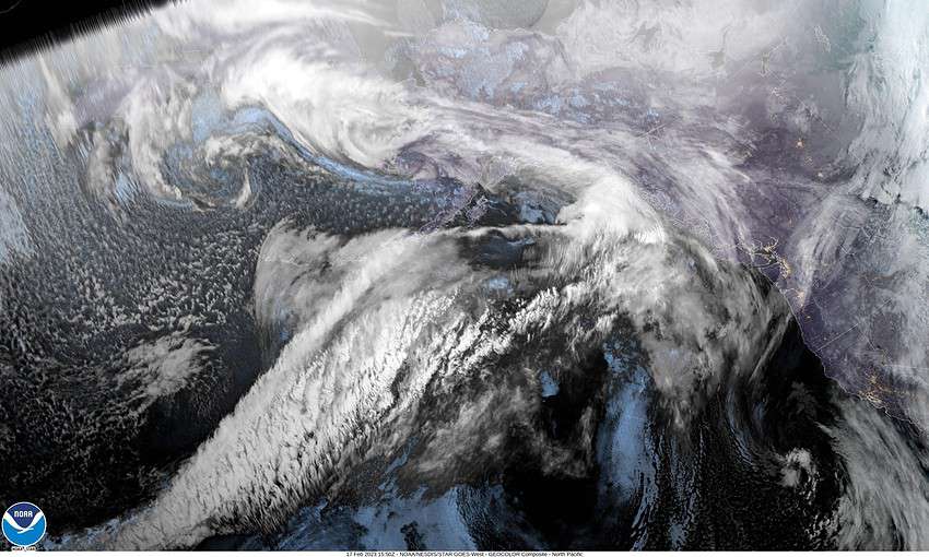
Looking at the satellite picture shows the cutoff low pressure area nearing southern California, a weak system that brought some light rain to the area, and a high pressure ridge in the Pacific that is holding a strong trough away, for now anyway.

So, the front drops southeastward tonight leaving us with cloudy skies, calm winds, and the low near 35.

Another weak front drops thru bringing some more rain starting later tomorrow morning lasting thru the afternoon, winds becoming westerly 5-10, highs near 48, then dry again tomorrow night with mostly cloudy skies, light westerly winds, lows near 38.

Sunday also looks dry to start, so mostly cloudy daytime skies, winds westerly 4-8, highs near 50, then we start to see more clouds, then a slight chance of rain late, lows near 41.

Monday starts the change with a disturbance dropping thru the area so for the holiday (Washington’s Birthday/Presidents Day) we will see cloudy and rainy conditions, the high near 50, becoming breezy Monday night, lows near 37.

By Tuesday we see a stronger, colder trough of low pressure pushing in heavier rain and strong winds that also lower the temperatures and snow levels. So, rainy and windy Tuesday with highs near 45, and the snow level, that started out at around 2000’, drops to around 1400’ that afternoon which would start to impact travel over the Coast Range passes. The rain continues Tuesday night, still windy, the lows drop to around 30. This means the snow level will continue to fall to around 800’ Tuesday night then low level snow is possible in the early morning hours as the temperatures nears then falls below freezing. Icing also becomes a concern.

Wednesday looks breezy and showery with lower level snow to start, still breezy, then as the temperatures rise, the snow level lifts to around 400’, the high only near 41. By Wednesday night, even colder air pushes in and we likely see snow to the beaches as the lows are expected to hit 21.

And Thursday we still have a chance of snow, still breezy, and the high only climbs to near 37.

Slide Slide Slide Slide Slide Slide Slide Slide Subscribe Contribute

Ads

Featured Video

Tillamook Weather

Tides

Tillamook County Pioneer Podcast Series

Tillamook Church Search

Cloverdale Baptist Church
Nestucca Valley Presbyterian
Tillamook Ecumenical Service

Archives

  • Home
  • EULA Privacy Policy
  • Contact
  • Opt-out preferences
  • Search...
Share on facebook
Facebook
Share on pinterest
Pinterest
Share on twitter
Twitter
Share on linkedin
Linkedin
Catherine

Recent Posts

  • ROCKAWAY BEACH READIES FOR JULY 4TH FESTIVITIES - HONORS VOLUNTEER OF YEAR & PARADE GRAND MARSHAL

    June 30, 2025
  • NEWS UPDATE FROM STATE REPRESENTATIVE DAVID GOMBERG: It's a Session Wrap!

    June 30, 2025
  • GORDON'S WEEKLY WEATHER UPDATE 6/30/25: Back to Normal Summer Weather This Week - Fair, Dry & Mild; Holiday Weekend Weather Looks Good

    June 30, 2025
©2025 | Theme by SuperbThemes

Manage Cookie Consent
To provide the best experiences, we use technologies like cookies to store and/or access device information. Consenting to these technologies will allow us to process data such as browsing behavior or unique IDs on this site. Not consenting or withdrawing consent, may adversely affect certain features and functions.
Functional Always active
The technical storage or access is strictly necessary for the legitimate purpose of enabling the use of a specific service explicitly requested by the subscriber or user, or for the sole purpose of carrying out the transmission of a communication over an electronic communications network.
Preferences
The technical storage or access is necessary for the legitimate purpose of storing preferences that are not requested by the subscriber or user.
Statistics
The technical storage or access that is used exclusively for statistical purposes. The technical storage or access that is used exclusively for anonymous statistical purposes. Without a subpoena, voluntary compliance on the part of your Internet Service Provider, or additional records from a third party, information stored or retrieved for this purpose alone cannot usually be used to identify you.
Marketing
The technical storage or access is required to create user profiles to send advertising, or to track the user on a website or across several websites for similar marketing purposes.
Manage options Manage services Manage {vendor_count} vendors Read more about these purposes
View preferences
{title} {title} {title}