")

By Gordon McCraw, Meteorologist for the Tillamook County Pioneer
Monday, March 6, 2023
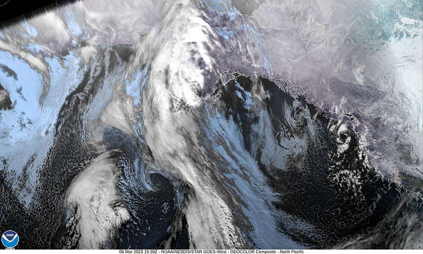
The models continue to show low pressure areas developing off the coast, then drifting into the coast somewhere from Washington down thru Oregon and even into California, thru at least midweek. One such low was spinning off the coast of southern Washington today that was rotating bands of showers across the region that was pulling the snow level down to the Coast Range passes temporarily in the heavier showers. The shower activity will continue to pop up tonight and because of the added instability, there continues to be a slight chance of thunderstorms this evening and tonight, mainly over the coast waters. Winds tonight southeasterly 8-12, the lows down near 36. The snow level falls overnight from around 1700’ this evening down to near 1000’ in the early morning hours, sometimes lower in the heavier showers.
The low continues to spin off the coast tomorrow so we continue to see showers rotating across the area, the winds southerly 5-10, highs up near 45, the snow level climbing back up to near 1700’. The low pressure area off the coast starts to weaken tomorrow night so the activity eases a little, the snow level drops to around 1400’ and with winds southeasterly 4-8, the early morning low drops to near 33. The snow level drops to near 800’ briefly lower in the showers.
By Wednesday, the low kicks inland but then we see another low pressure area dropping southward from the British Columbia coast that will be pulling in more cool air, and more showers. This means we continue to have a chance of showers with lower morning snow possible until the temperatures rise, the snow level 900’ that morning but climbing with daytime heating to near 1500’. Winds southerly 5-10, highs near 46. Wednesday night looks rainy and breezy with the low now parked off the coast, lows near 36 so the snow level likely around 1300’.
Thursday the low may have drifted a little further west which would ease the rain or shower activity a little though we likely remain on the breezy side, the snow level climbs up near 1800’ and with more rain that night, the snow level climbs above 2000’ though the surface temperature is around 35.
Now here is where things start to get more interesting, and harder to forecast. It appears the jet stream will interact with and push a large area of moisture from southern Japan towards the U.S. West Coast. The current modeling pushes this plume of moisture towards northern California though some of the moisture could get absorbed by that low pressure area off our coast. A lot of the forecast from Friday on depends on where, and when this moisture interacts with the low pressure area off our coast, and exactly how far off the coast this low remains. For now, we just go with rainy and breezy Friday, the snow level continues to climb thanks to the interaction with the subtropical jet, highs near 48, the snow level around 2500’. Still rainy and breezy Friday night as the low starts lifting northward, lows near 35.
This part of the forecast is something we want to keep an eye on as any changes could have a significant impact on the coastal rivers. For now, our river forecasts do show an increase in flow rates over the weekend but nothing significant.
The low finally moves inland Saturday, but we still see the rain, highs near 50, then our stubborn pattern continues with yet another low pressure area arriving off the coast Sunday morning, so we continue to be wet and cool with highs near 51, lows near 37.