Menu
  • Home
  • Feature
    • Breaking News
    • Arts
    • Astrology
    • Business
    • Community
    • Employment
    • Event Stories
    • From the Pioneer
    • Government
    • Letters to the Editor
    • Non Profit News
    • Obituary
    • Public Safety
    • Podcast Interview Articles
    • Pioneer Pulse Podcast: Politics, Palette, and Planet – the Playlist
  • Guest Column
    • Perspectives
    • Don Backman Photos
    • Ardent Gourmet
    • Kitchen Maven
    • I’ve been thinking
    • Jim Heffernan
    • The Littoral Life
    • Neal Lemery
    • View From Here
    • Virginia Carrell Prowell
    • Words of Wisdom
  • Weather
  • Post Submission
  • Things to do
    • Calendar
    • Tillamook County Parks
    • Tillamook County Hikes
    • Whale Watching
    • Tillamook County Library
    • SOS Community Calendar
  • About
    • Contribute
    • Advertise
    • Subscribe
    • Opt-out preferences
  • Search...
Menu

GORDON’S UPDATE: Weather 6/26/23 – Warming up for the holiday weekend

Posted on June 26, 2023 by Editor

By Gordon McCraw, Meteorologist for the Tillamook County Pioneer

The summer weather pattern has settled in. Currently we have an upper level weak trough with an associated low pressure area drifting eastward from central Oregon/Washington as a ridge of high pressure builds in just to the west. This will again enhance the onshore flow tonight, which thickens the marine layer, possibly giving us some patchy morning drizzle. So, the overnight forecast is for cloudy skies with light northwesterly winds tonight, patchy drizzle possible in the early morning hours, lows near 52.

The trough and low slowly start to move eastward tomorrow but we still see the marine clouds leaving us with a mostly cloudy day, the winds becoming westerly 5-10, highs near 66, a cloudy to mostly cloudy night, light winds again, lows near 52.

By Wednesday the trough and low pressure area should have drifted into eastern Oregon or western Idaho as the ridge of high pressure builds northeastward into Washington. This will give us a partly sunny day with winds becoming westerly 5-10, the high warming to near 68. With the ridge continuing to build into Oregon which pushes the trough even further east, we will see a partly cloudy night Wednesday, light winds, lows near 52.

Thursday, we see a mostly sunny day with highs inching up near 71 in the afternoon, then another partly cloudy night, lows near 53.

It looks like Friday another upper level low pressure area moves into the Gulf of Alaska area, again enhancing the westerly flow and flattens the ridge some, which in turn cools things down a little so we can expect mostly sunny skies still, but the high tops out at 69. The flow gives us some breezy winds overnight under mostly clear skies, the low near 53.

The weekend picture becomes a little muddier. The overall pattern will be that the upper level low pressure area will have drifted a little to the southeast toward the Canadian coastline while a high pressure center remains over central California with the ridge extending northeastward through Idaho. We could see some warmer temperatures moving northward from California into Oregon as a result, but the question becomes how quickly, and how hot. For now, we go with sunny skies Saturday, remaining breezy, the high near 70, lows under mostly clear skies, near 50. For Sunday we see sunny skies again, the high near 74, still cloud free that night, lows near 51.

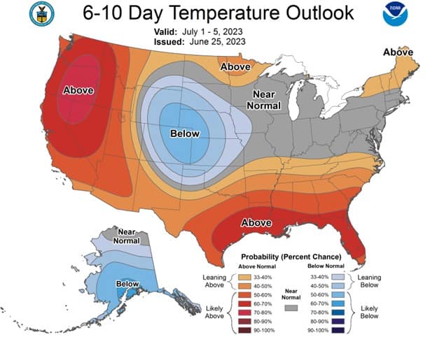
The long range models continue to show warmer temperatures for the first week of July. The question next week remains…how warm? For now, it looks like the coast will not be excessively hot, thanks to the continued onshore flow, but the same cannot be said for over in the valley. July 1st through the 4th are the questionable days for the valley. The models show a variety of warm or hot temperatures. Overall, there is a 10-20% chance the valley could see temperature near 100 over that period. Some of the models show highs from the 70s to the 80s. The greater chance is for highs there in the upper 80s to low 90s. Even the Climate Prediction Center is forecasting a 60-70% chance of above normal temperature between July 1 – 5 with a 70-80% chance in central and eastern Oregon. It looks like things moderate after the 5th.


Slide Slide Slide Slide Slide Slide Slide Slide Subscribe Contribute

Ads

Featured Video

Tillamook Weather

Tides

Tillamook County Pioneer Podcast Series

Tillamook Church Search

Cloverdale Baptist Church
Nestucca Valley Presbyterian
Tillamook Ecumenical Service

Archives

  • Home
  • EULA Privacy Policy
  • Contact
  • Opt-out preferences
  • Search...
Share on facebook
Facebook
Share on pinterest
Pinterest
Share on twitter
Twitter
Share on linkedin
Linkedin
Catherine

Recent Posts

  • WHAT DOES FREEDOM MEAN TO YOU? Remember: Freedom

    July 2, 2025
  • TILLAMOOK'S JUNE DAIRY PARADE - JUNE 28, 2025 - Photo Slideshow & Video

    July 2, 2025
  • 142ND WING TO CONDUCT INDEPENDENCE DAY FLYOVERS - Manzanita, Rockaway Beach & Neskowin in Tillamook County

    July 2, 2025
©2025 | Theme by SuperbThemes

Manage Cookie Consent
To provide the best experiences, we use technologies like cookies to store and/or access device information. Consenting to these technologies will allow us to process data such as browsing behavior or unique IDs on this site. Not consenting or withdrawing consent, may adversely affect certain features and functions.
Functional Always active
The technical storage or access is strictly necessary for the legitimate purpose of enabling the use of a specific service explicitly requested by the subscriber or user, or for the sole purpose of carrying out the transmission of a communication over an electronic communications network.
Preferences
The technical storage or access is necessary for the legitimate purpose of storing preferences that are not requested by the subscriber or user.
Statistics
The technical storage or access that is used exclusively for statistical purposes. The technical storage or access that is used exclusively for anonymous statistical purposes. Without a subpoena, voluntary compliance on the part of your Internet Service Provider, or additional records from a third party, information stored or retrieved for this purpose alone cannot usually be used to identify you.
Marketing
The technical storage or access is required to create user profiles to send advertising, or to track the user on a website or across several websites for similar marketing purposes.
Manage options Manage services Manage {vendor_count} vendors Read more about these purposes
View preferences
{title} {title} {title}