Menu
  • Home
  • Feature
    • Breaking News
    • Arts
    • Astrology
    • Business
    • Community
    • Employment
    • Event Stories
    • From the Pioneer
    • Government
    • Letters to the Editor
    • Non Profit News
    • Obituary
    • Public Safety
    • Podcast Interview Articles
    • Pioneer Pulse Podcast: Politics, Palette, and Planet – the Playlist
  • Guest Column
    • Perspectives
    • Don Backman Photos
    • Ardent Gourmet
    • Kitchen Maven
    • I’ve been thinking
    • Jim Heffernan
    • The Littoral Life
    • Neal Lemery
    • View From Here
    • Virginia Carrell Prowell
    • Words of Wisdom
  • Weather
  • Post Submission
  • Things to do
    • Calendar
    • Tillamook County Parks
    • Tillamook County Hikes
    • Whale Watching
    • Tillamook County Library
    • SOS Community Calendar
  • About
    • Contribute
    • Advertise
    • Subscribe
    • Opt-out preferences
  • Search...
Menu

GORDON’S UPDATE: Weather 9/25/23 – Rain throughout the week … Hello, Fall!

Posted on September 25, 2023 by Editor

By Gordon McCraw, Meteorologist for the Tillamook County Pioneer
The first weather system of the season continues to bring rain into the area, we had yet another front slowly move ashore this morning, bringing yet another round of rain across the area. In the last 24 hours ending at 8:00am this morning, Tillamook Airport reported .35” of rain while Lees Camp in the Coast Range reported .70” of rain, Mt. Hebo reported 1.21” and Central and Southern Coastal Oregon has seen over 1.5”. Some good news though, besides putting a real damper on the wildfires, the lower rain rates with the breaks between systems has allowed the rivers to not rise significantly, with the forecast still that they will only climb around 1-3’ over the next couple days.

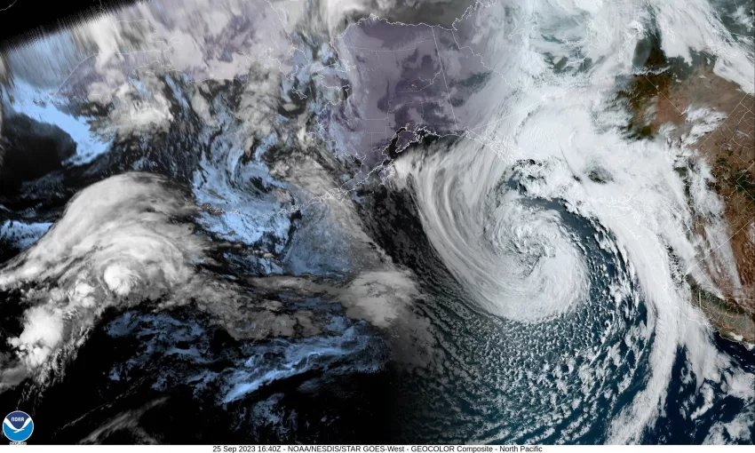
The driving force continues to be a large and strong low pressure center currently spinning in the northeastern Pacific. It looks like the low has started to slowly weaken but will continue to rotate other disturbances under the low and across our area. The front continues to drift eastward but the strong southwesterly flow will push clouds and moisture up across our area, so the cloudy, rainy conditions continue tonight, also with a chance of some thunderstorms along with some breezy southerly winds 15-20 gusting to 30, with gusts to 40-45 possible at the beaches, lows near 52.

It is likely that another low pressure center will develop in the flow tomorrow and rotate into Washington by tomorrow night. This will give us more rain with possible thunderstorms during the day tomorrow, the winds southerly 14-18 gusting to 30, highs near 62. Then the winds likely ramp up tomorrow night, still with rain and possible thunderstorms, those winds southerly 18-24 gusting to near 40, lows near 50. As is always the case, there are many factors that can affect the strength and path of these lows that the models fail to pick up. Having said that, there is a chance that the low develops sooner, and weakens sooner, but the opposite is also true, it could develop later and stronger and that would bring winds as high as 55 (or higher) to the beaches. The best advice is to be ready for whatever.

So, we expect the low to move into coastal Washington Wednesday morning but that would still be rotating morning rain, then afternoon rainshowers with possible thunderstorms across our area, the winds start to slowly subside, becoming southwesterly 14-18 gusting to 25-30, highs near 62, then only scattered showers Wednesday night under mostly cloudy skies, the low down to near 48.

Thursday on it looks like we will continue to be influenced by a trough or two that move across the area, so Thursday we see more scattered showers under mostly cloudy skies, highs only near 60 and lows down near 47. Some patchy morning fog is also possible.

Friday conditions start to improve some, a partly sunny day with scattered showers, the high near 61, the showers become more widely scattered by Friday night, patchy morning fog possible again, lows drop to near 43.
Things look like they dry out over the weekend with the return of mostly sunny skies, the highs up near 64 Saturday, and up to near 66 Sunday, the lows up near 45 by Sunday.

Slide Slide Slide Slide Slide Slide Slide Slide Subscribe Contribute

Ads

Featured Video

Tillamook Weather

Tides

Tillamook County Pioneer Podcast Series

Tillamook Church Search

Cloverdale Baptist Church
Nestucca Valley Presbyterian
Tillamook Ecumenical Service

Archives

  • Home
  • EULA Privacy Policy
  • Contact
  • Opt-out preferences
  • Search...
Share on facebook
Facebook
Share on pinterest
Pinterest
Share on twitter
Twitter
Share on linkedin
Linkedin
Catherine

Recent Posts

  • ROCKAWAY BEACH READIES FOR JULY 4TH FESTIVITIES - HONORS VOLUNTEER OF YEAR & PARADE GRAND MARSHAL

    June 30, 2025
  • NEWS UPDATE FROM STATE REPRESENTATIVE DAVID GOMBERG: It's a Session Wrap!

    June 30, 2025
  • GORDON'S WEEKLY WEATHER UPDATE 6/30/25: Back to Normal Summer Weather This Week - Fair, Dry & Mild; Holiday Weekend Weather Looks Good

    June 30, 2025
©2025 | Theme by SuperbThemes

Manage Cookie Consent
To provide the best experiences, we use technologies like cookies to store and/or access device information. Consenting to these technologies will allow us to process data such as browsing behavior or unique IDs on this site. Not consenting or withdrawing consent, may adversely affect certain features and functions.
Functional Always active
The technical storage or access is strictly necessary for the legitimate purpose of enabling the use of a specific service explicitly requested by the subscriber or user, or for the sole purpose of carrying out the transmission of a communication over an electronic communications network.
Preferences
The technical storage or access is necessary for the legitimate purpose of storing preferences that are not requested by the subscriber or user.
Statistics
The technical storage or access that is used exclusively for statistical purposes. The technical storage or access that is used exclusively for anonymous statistical purposes. Without a subpoena, voluntary compliance on the part of your Internet Service Provider, or additional records from a third party, information stored or retrieved for this purpose alone cannot usually be used to identify you.
Marketing
The technical storage or access is required to create user profiles to send advertising, or to track the user on a website or across several websites for similar marketing purposes.
Manage options Manage services Manage {vendor_count} vendors Read more about these purposes
View preferences
{title} {title} {title}