Menu
  • Home
  • Breaking News
  • Feature
    • Arts
    • Astrology
    • Business
    • Community
    • Employment
    • Event Stories
    • From the Pioneer
    • Government
    • Letters to the Editor
    • Non Profit News
    • Obituary
    • Public Safety
    • Podcast Interview Articles
    • Pioneer Pulse Podcast: Politics, Palette, and Planet – the Playlist
  • Weather
  • Guest Column
    • Perspectives
    • Don Backman Photos
    • Ardent Gourmet
    • Kitchen Maven
    • I’ve been thinking
    • Jim Heffernan
    • The Littoral Life
    • Neal Lemery
    • View From Here
    • Virginia Carrell Prowell
    • Words of Wisdom
  • Things to do
    • Calendar
    • Tillamook County Parks
    • Tillamook County Hikes
    • Whale Watching
    • Tillamook County Library
    • SOS Community Calendar
  • About
    • Contribute
    • Advertise
    • Subscribe
    • Opt-out preferences
  • Post Submission Test
  • Search...
Menu

GORDON’S Weather/Storm Update EXTRA – 11/19/24: Hold on to your hats folks, it’s gonna be a windy evening, but no flooding expected.

Posted on November 19, 2024 by Editor

By Gordon McCraw, Meteorologist for the Tillamook County Pioneer
Tuesday, November 19, 2024, 10:30am

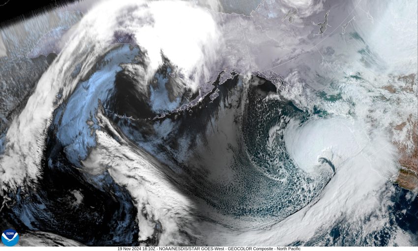
Satellite image – Kinda impressive…the low is expected to move a little closer to the coast then turn north, heading to Vancouver Island

A quick update on the incoming impactful weather. So, we are looking at a pretty strong system moving in today and impacting the area through early tomorrow, that will bring real strong gusty winds along the beaches and headlands with some strong winds likely inland as well. The beaches could see winds gusting to 50-65, with about a 30% chance of some areas seeing gusts to 70-95. In town, you can expect winds gusts 35-45, possibly gusting as high as 50-55 at times. The wind should increase around noon to 1:00pm today and linger through around 4:00am tomorrow morning. There is a chance that the winds don’t pick up until 3:00-5:00 this evening but the best chance is around 1:00pm. Obviously, this could impact the county with fallen trees blocking roads and/or into powerlines causing power outages. There is a High Winds Warning for Tillamook from 1pm today through 4am tomorrow. Next, let’s review the ocean, where there are Storm Warnings from 10:00am this morning through 1:00pm today, then a Hurricane Force Wind Warning starting at 1pm today through 10pm tonight. As you might expect, this will cause dangerously high surf conditions and thus a High Surf Advisory starts at 7pm this evening, valid though 4pm tomorrow. If you must go to the beach, know that these waves can lift large logs that can cause serious bodily harm, and the waves can also knock you down and drag you out into the ocean. So, use extreme caution and remain clear of the surf.

Last night, the Coast Range saw quite a bit of snow, all the way down to Lees Camp, that gave drivers white-out conditions at times. This morning ODOT was reporting that there was 4” of new snow roadside with bare pavement. With this being a warmer system, the snow level should be rising and bringing improving driving conditions across the summit. Now, let’s look at the rain, yes, we can expect periods of moderate to heavy rain, but it continues to show the heaviest rain will be into southern Oregon and northern California, so while we could see some Urban and Small Stream flooding, river flooding concerns remain low. It appears today we can expect ¾” to 1 ½” of rain with another ¼ to ¾” tomorrow. The Coast Range is likely to see 2 ½” to 3” through tomorrow. So, to summarize, it looks like this will be a high wind event, the strongest we have seen this season, that could cause road and power issues. The seas will be increasing with waves possibly up to 20-25’ tonight, causing dangerous surf conditions along the beaches. Again, it appears we have no river flooding concerns, just some localized flooding related to drainage.

Featured Video

Slide Contribute SUBSCRIBE

Tillamook Weather

Tides

Tillamook County Pioneer Podcast Series

Tillamook Church Search

Cloverdale Baptist Church
Nestucca Valley Presbyterian
Tillamook Ecumenical Service

Archives

  • Home
  • EULA Privacy Policy
  • Contact
  • Opt-out preferences
  • Search...
Share on facebook
Facebook
Share on pinterest
Pinterest
Share on twitter
Twitter
Share on linkedin
Linkedin
Catherine

Recent Posts

  • Tillamook Air Museum to Acquire Historic U.S. Coast Guard HU-25 Guardian

    May 24, 2025
  • Celebrate May at Camp Magruder with Two Special Events: Camp Magruder’s 80th Anniversary Celebration May 24th & Community Open House May 31st

    May 24, 2025
  • RESIDENTS STAND TOGETHER AGAINST CIRCUS CRUELTY IN TILLAMOOK, PROTEST OF JORDAN CIRCUS AT TILLAMOOK COUNTY FAIRGROUNDS TUESDAY MAY 27th

    May 24, 2025
©2025 | Theme by SuperbThemes

Manage Cookie Consent
To provide the best experiences, we use technologies like cookies to store and/or access device information. Consenting to these technologies will allow us to process data such as browsing behavior or unique IDs on this site. Not consenting or withdrawing consent, may adversely affect certain features and functions.
Functional Always active
The technical storage or access is strictly necessary for the legitimate purpose of enabling the use of a specific service explicitly requested by the subscriber or user, or for the sole purpose of carrying out the transmission of a communication over an electronic communications network.
Preferences
The technical storage or access is necessary for the legitimate purpose of storing preferences that are not requested by the subscriber or user.
Statistics
The technical storage or access that is used exclusively for statistical purposes. The technical storage or access that is used exclusively for anonymous statistical purposes. Without a subpoena, voluntary compliance on the part of your Internet Service Provider, or additional records from a third party, information stored or retrieved for this purpose alone cannot usually be used to identify you.
Marketing
The technical storage or access is required to create user profiles to send advertising, or to track the user on a website or across several websites for similar marketing purposes.
Manage options Manage services Manage {vendor_count} vendors Read more about these purposes
View preferences
{title} {title} {title}