")

By Gordon McCraw, Meteorologist for the Tillamook County Pioneer
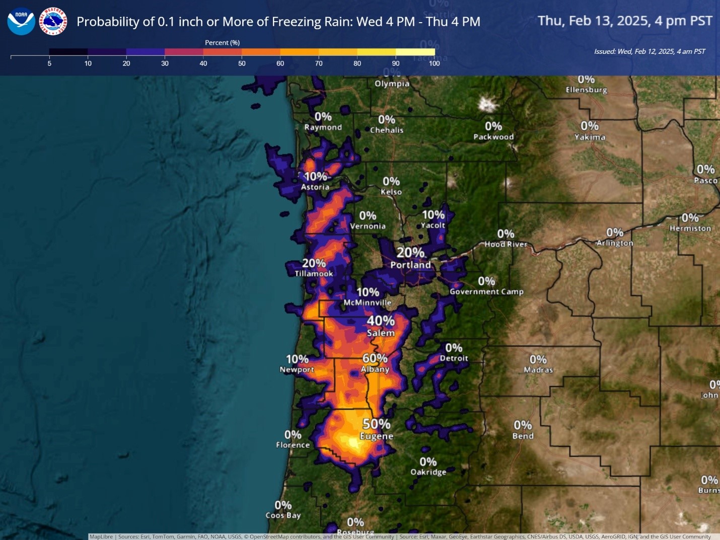
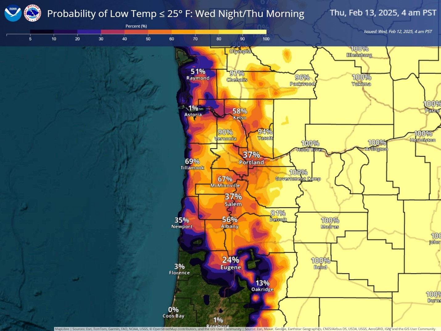
Another cold, clear full moon night last night with the low dropping to near 21. Now today, we can look forward to a significant weather change. We did see another mostly sunny day today as we watch a low pressure area, and its associated warm moisture from moving eastward toward to the coast that will start impacting the coast in the early morning hours tonight. The issue is…the cold surface temperatures will still be locked in place tonight, with the temperature dropping to below freezing around 10pm tonight. With the expected incoming precipitation that is moving in from the southwest after midnight into the early morning hours, there is a slight chance of snow or freezing rain. That chance increases with snow or freezing rain likely a few hours before the sun comes up tomorrow, Thursday Feb. 13th, though things are leaning more like freezing rain now. The overnight low drops to near 28, though that will feel colder with the windchill, thanks to the easterly winds 8-12 gusting to 25, it will fill like the teens. Snow accumulating is expected to be less than ½” and the ice accumulation is expected to be less than one tenth of an inch. See the graphics below.
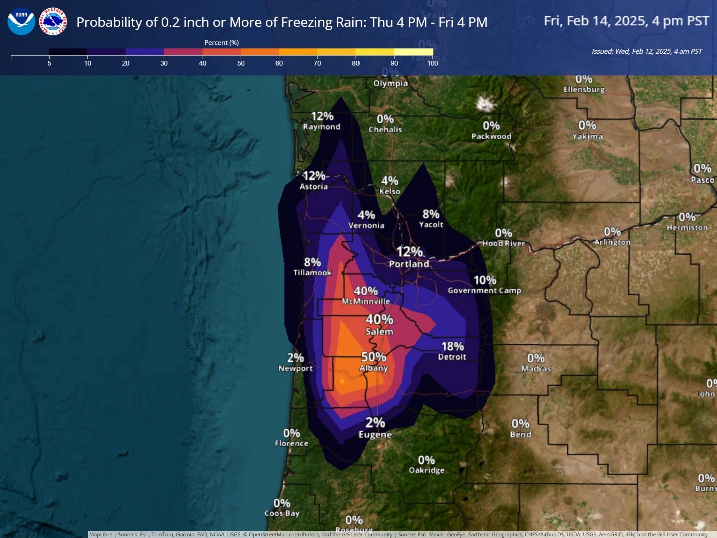
Now tomorrow, Thursday Feb. 13, the warmer air will push in but the cold surface air continues to hold on, so we can see a mix of snow and freezing rain, maybe sleet, through around noon tomorrow. Then changing over to mostly rain as the high temperature tomorrow peaks out at around 40, the winds still easterly 8-12 gusting to near 25. Snow accumulation is expected to be less than ½” for the day with light amounts of freezing rain.
Friday morning, we see decreasing precipitation, and mainly just rain with the warming temperatures, the afternoon high near 45. It looks like we have another incoming system that will bring an increasing chance of rain later Friday evening with rain likely Friday night, highs near 46, lows near 34.
Unfortunately, the weekend looks cloudy and wet, but a little warmer, with afternoon highs in the upper 40s to low 50s, and lows only down to near 40. And, more cloudy and wet for President’s Day Monday Feb. 17, highs 51, lows near 39.
Now, there is still some uncertainty in the forecast. The issue is timing and temperature. If the rain moves in early, there is a better chance of seeing snow first, if the temperatures are too slow to rise, then the wintery precipitation lingers longer. Remember too, because of elevation, the Coast Range Summit will be colder longer. It will likely start out as snow there tonight then transition to snow, freezing rain, and/or sleet tomorrow that persists into Friday with a chance still on Saturday morning until things warm to above freezing. Because of this, there has been a Winter Storm Watch issued for the Coast Range, including the summit, that will take effect this evening and last through Friday morning with heavy mixed precipitation possible. There could be up to 2” of snow and/or ¼” of ice across that area. There is still a Cold Weather Advisory for the area effective from 7pm tonight through noon tomorrow.
This all means that starting tomorrow morning things will be dicey and icy, longer across the summit. Remember, the roads, and especially the bridges and overpasses, will likely become slick and hazardous. Also, if we get significant ice accumulation on the power lines and tree limbs, we may see widespread power outages. If you need to get supplies, today is the day. If you lose power, do you have a plan considering the freezing temperatures? If not, now is the time to work that out. So, be ready, and be safe!
Now, a major alert for all the guys, and girls…remember Friday the 14th is Valentines Day!