Menu
  • Home
  • Breaking News
  • Feature
    • Arts
    • Astrology
    • Business
    • Community
    • Employment
    • Event Stories
    • From the Pioneer
    • Government
    • Letters to the Editor
    • Non Profit News
    • Obituary
    • Public Safety
    • Podcast Interview Articles
    • Pioneer Pulse Podcast: Politics, Palette, and Planet – the Playlist
  • Weather
  • Guest Column
    • Perspectives
    • Don Backman Photos
    • Ardent Gourmet
    • Kitchen Maven
    • I’ve been thinking
    • Jim Heffernan
    • The Littoral Life
    • Neal Lemery
    • View From Here
    • Virginia Carrell Prowell
    • Words of Wisdom
  • Things to do
    • Calendar
    • Tillamook County Parks
    • Tillamook County Hikes
    • Whale Watching
    • Tillamook County Library
    • SOS Community Calendar
  • About
    • Contribute
    • Advertise
    • Subscribe
    • Opt-out preferences
  • Post Submission Test
  • Search...
Menu

GORDON’S WEEKLY WEATHER UPDATE 10/7/24: Periods of showers this week; Climate Prediction Center’s October Outlook

Posted on October 7, 2024 by Editor

By Gordon McCraw, Meteorologist for the Tillamook County Pioneer
Today’s weather was still being influenced by a high pressure ridge, though it drifted east a little. It did manage to give us another mostly sunny day today with relatively light winds, and a high in the low 70s. We will see increasing clouds tonight though, then a chance of light showers after midnight as a weak and dying front approaches. So we can expect mostly cloudy skies with that chance of some light showers in the early morning hours, some calm winds, the low dropping to near 49.

We see another weak front move in tomorrow that gives us a better chance of some rain or rainshowers, the winds becoming southwesterly 4-8, the afternoon high temperature only up near 64. Still a chance of some light showers tomorrow night, some patchy fog possible with the light winds, lows again near 49.

Yet another weak system gives us a chance of showers Wednesday, the winds becoming westerly 4-8, high temperatures around 62. The chance of showers diminishes by midnight, again some patchy fog possible with calm winds, lows dropping to near 44.

A weak ridge of high pressure moves across on Thursday bringing us a mostly sunny day, the high near 65, then a weak trough slides across the top of the ridge and brings in another slight chance of showers after midnight Thursday, the low near 47.

The models get mixed after that but, for now anyway, Friday is looking like a low pressure area, and an associated trough, will be out off of the Oregon coast, in the eastern Pacific. The wrap around moisture could spell more showers Friday with a chance still on Saturday, then we have another low pressure area pushing in more showers Sunday into Monday. After that, it appears high pressure returns for Tuesday to bring back the fair, dry, and mild conditions through at least midweek. Again, there is some variations in the models so this could change as the models become better aligned in the next day or two.

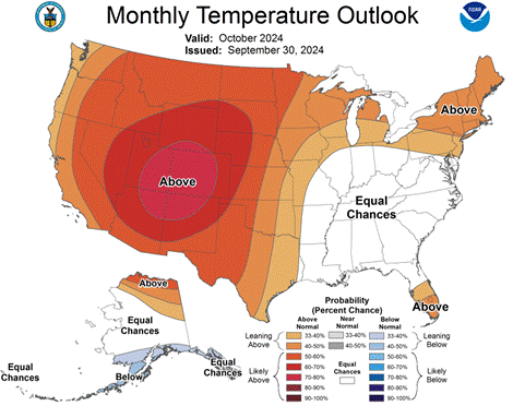
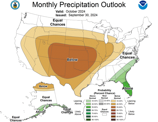
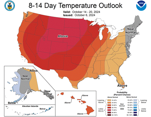
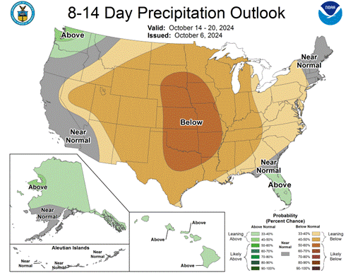
So, I missed that the Climate Prediction Center issued the Monthly Outlook for October so I will include it today. The forecast issued September 30th for the month of October shows equal probabilities of above or below normal precipitation for the month, and a 33-40% chance of above normal temperatures for the month. They do say that for the period of October 14-20 that they are leaning slightly towards above normal precipitation for that period, with a better chance of above normal temperatures for that same period.


Featured Video

Slide Contribute SUBSCRIBE

Tillamook Weather

Tides

Tillamook County Pioneer Podcast Series

Tillamook Church Search

Cloverdale Baptist Church
Nestucca Valley Presbyterian
Tillamook Ecumenical Service

Archives

  • Home
  • EULA Privacy Policy
  • Contact
  • Opt-out preferences
  • Search...
Share on facebook
Facebook
Share on pinterest
Pinterest
Share on twitter
Twitter
Share on linkedin
Linkedin
Catherine

Recent Posts

  • LOCAL VFW POST RAISES $1,500, GETS MATCHING GRANT - $3,000 FOR LOCAL FOOD ORGANIZATIONS

    May 20, 2025
  • OREGON DEPT. OF FISH & WILDLIFE: More spring Chinook fishing days on Columbia River mainstem as run expected to come in above forecast 

    May 20, 2025
  • Check out AWARD-WINNING incredible “Coastal Futures” project on display at Rockaway Beach Library

    May 20, 2025
©2025 | Theme by SuperbThemes

Manage Cookie Consent
To provide the best experiences, we use technologies like cookies to store and/or access device information. Consenting to these technologies will allow us to process data such as browsing behavior or unique IDs on this site. Not consenting or withdrawing consent, may adversely affect certain features and functions.
Functional Always active
The technical storage or access is strictly necessary for the legitimate purpose of enabling the use of a specific service explicitly requested by the subscriber or user, or for the sole purpose of carrying out the transmission of a communication over an electronic communications network.
Preferences
The technical storage or access is necessary for the legitimate purpose of storing preferences that are not requested by the subscriber or user.
Statistics
The technical storage or access that is used exclusively for statistical purposes. The technical storage or access that is used exclusively for anonymous statistical purposes. Without a subpoena, voluntary compliance on the part of your Internet Service Provider, or additional records from a third party, information stored or retrieved for this purpose alone cannot usually be used to identify you.
Marketing
The technical storage or access is required to create user profiles to send advertising, or to track the user on a website or across several websites for similar marketing purposes.
Manage options Manage services Manage {vendor_count} vendors Read more about these purposes
View preferences
{title} {title} {title}