")
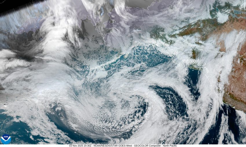

Well, we had a bit of rain over the weekend, in fact on Saturday there was just over 5” in the Coast Range that sent the Wilson River nearly up into Action Stage. Yesterday, we had a weak ridge but this morning, the ridge had pushed eastward as a trough of low pressure was moving into the northeastern Pacific. This put us under a southwesterly flow that pushed a disturbance up into the area, bringing us some light, occasionally moderate rain today. This afternoon a low pressure area also developed in the trough and also rode in the flow, enhancing the rain this afternoon that continues tonight. As far as winds, the coastal beaches will see a period of gusty winds of between 20 to 25 this evening and there is an enhanced chance of sneaker waves so be extra careful down near the surf region.
Now, the rest of this week is looking pretty active. The big picture, there is a large low pressure area that develops in the Pacific to our northwest, that will rotate disturbances up across the area, and starting tomorrow night, Tuesday, we see a series of fronts that bring periods of moderate to heavy rain and gusty winds through Friday. Throw in that we are coming into a period of astronomically high tides (King Tides) and seeing some periods of Coastal High Tide flooding in areas like downtown Nehalem, Fraser Rd in Tillamook, and down towards Pacific City, is not out of the question. (Coastal Flood Advisory has already been issued for Wednesday 11/5/25)
So, the forecast looks like this, again, a rainy night tonight with diminishing winds, the low near 45. Then tomorrow, the rain continues with easterly winds 5-10, the high near 60. Still rainy tomorrow night with the first in the series of fronts, the winds becoming southeasterly 10-15 gusting to 25, gusting to 45 down at the beaches, the overnight low near 50.
The front pushes though by late Wednesday morning then we transition to showers with possible thunderstorms. The winds increasing to 20-25 gusting to 35 with gusts to 50 possible down at the beaches, the high near 56. Still rain and windy Wednesday night, and with that chance of thunderstorms, the low near 53.
Another system moves in Thursday and brings moderate to occasionally heavy rain to the area along with strong winds that persist through Thursday night, highs near 59, lows near 47. Again, all this during a period of astronomically high tides…and…there is concern about the rivers reaching minor flood stage with all this rain as well. We could also see Urban and Small Stream flooding during the heavy rain periods.
More rain is expected Friday but not as impactful as the previous days, highs near 56, lows near 43.
The weekend also looks wet with highs near 61, lows near 48.
So, the bottom line is this, keep a close eye on the weather this week as I am sure we will be seeing lots of Advisories, Watches and Warnings related to these events. Now is the time to be ready, if you live or work in a flood prone area, it’s time to dust off, or develop an emergency action plan, if you own any of the carts in the North Main area, be ready in case the Wilson River floods later this week. The river forecasts don’t show any flooding right now, but the National Weather Service put the chance at about 25%, for now, which can change each upcoming model run. Know also that there will be flooding in areas related to the astronomically high tides combining with the elevated river levels that are expected to peak at the end of the week. Finally, the winds could down some trees, causing some sporadic power outages.
And there you have it Tillamook, I remember that November was always a busy weather period back when I was the Emergency Manager, and it looks like this year will be no exception, so stay tuned and monitor the weather this week for changes, good or bad.
That’s it, so, everyone stay safe and watch the weather.