")

By Gordon McCraw, Meteorologist for the Tillamook County Pioneer
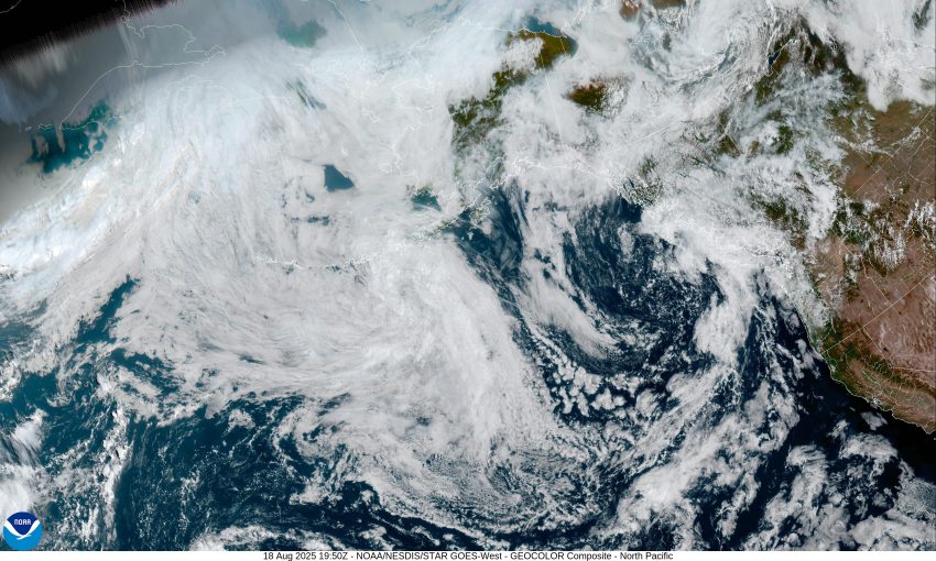
Today’s weather picture has a large upper level low pressure area spinning around in the eastern Pacific, northwest of Vancouver Island, with its associated trough extending southwestward well to our west in the Pacific. And, we see an upper level ridge of high pressure to the east, building in the southwestern U.S. A disturbance riding up in the flow this morning gave us some cloudiness, but conditions improved this afternoon, bringing us a mostly sunny day. Tonight, we see the clouds and patchy fog returning along with the calm winds, the low temperature around 52.
With little change in the synoptic picture, the fog and clouds give way to a party to mostly sunny day tomorrow, the winds becoming westerly 5-10 in the afternoon, with the highs up near 70. No change tomorrow night so in comes the patchy fog and clouds again with calm winds, the low near 54.
One more day of “the same” for Wednesday, the fog and clouds burning back to leave a mostly sunny to sunny afternoon, the winds becoming northwesterly 8-12, the afternoon high near 71. The ridge of high pressure to the southeast pushes northwesterly towards the area, Wednesday night likely stays mostly clear, the low near 51.
The ridge continues to build northward and drift westward some Thursday on, and that brings less cloudiness and warms things up again. So, Thursday looks sunny with the afternoon high temperature hitting around 74. Then with lower pressure to the west, the building ridge to the east, along with temperatures in the 90s over in the valley, we expect increasing winds later that afternoon and evening, the overnight temperature around 54.
We see sunny skies on Friday with the afternoon high temperatures peaking at around 76, then another mostly clear night, the low near 55. The sunny and warm conditions continue Saturday with the high near 73, and with partly cloudy skies, the overnight low temperature Saturday near 54.
It appears the high pressure area begins to shift back to the southeast Sunday which allows some of the marine clouds to return in the early morning hours, so we see partly sunny skies to start but the clouds burn back, leaving sunny skies in the afternoon with the highs still up around 72 degrees, the low around 52.
Finally, looking down the road, I don’t see another chance of rain until around the end of next week, so, summer continues.