Tillamook County Pioneer

News & People of Tillamook County. Every Day.

Menu
  • Home
  • Feature
    • Breaking News
    • Arts
    • Astrology
    • Business
    • Community
    • Employment
    • Event Stories
    • From the Pioneer
    • Government
    • Letters to the Editor
    • Non Profit News
    • Obituary
    • Public Safety
    • Podcast Interview Articles
    • Pioneer Pulse Podcast: Politics, Palette, and Planet – the Playlist
  • Guest Column
    • Perspectives
    • Don Backman Photos
    • Ardent Gourmet
    • Kitchen Maven
    • I’ve been thinking
    • Jim Heffernan
    • The Littoral Life
    • Neal Lemery
    • View From Here
    • Virginia Carrell Prowell
    • Words of Wisdom
    • Chuck McLaughlin – 1928 to 2025
  • Weather
  • Post Submission
  • Things to do
    • Calendar
    • Tillamook County Parks
    • Tillamook County Hikes
    • Whale Watching
    • Tillamook County Library
    • SOS Community Calendar
  • About
    • Contribute
    • Advertise
    • Subscribe
    • Opt-out preferences
  • Search...
Menu

GORDON’S WEEKLY WEATHER UPDATE: Look back at 2025 weather by the numbers & the forecast

Posted on January 5, 2026January 5, 2026 by Editor

By Gordon McCraw, Meteorologist for the Tillamook County Pioneer

And here we are with the first forecast for 2026. First though, let’s look back at some of the numbers for 2025. Using a weather station there in the North Main area, I saw that it recorded about 89.93” of rain for the year which is a little below the average of 93.51” The warmest day of 2025 was on September the 16th when it got up to around 89 while the coldest was on January 19th when it dipped to near 23 degrees. Now as for the averages for January, it looks like we have 52 for a high and 37 for the low. From what I have seen so far, I would say January is also a wet month.

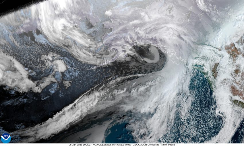
Now, the current forecast. With a low pressure area and trough moving eastward from northern California through central and northeastern Oregon, and another system moving down from British Columbia, we are left in between with a weak ridge of high pressure that gave us a relatively nice, but cool day today. Tonight though, we see some patchy early morning fog, then some increasing clouds as the next weather system approaches from the northwest. The winds tonight will become light from the southeast and the low drops to around 36.

So, we see the first front bringing rain in again after around 4am tomorrow morning, with breezy southerly winds starting out at 10-15 gusting to 20 but becoming 15 to 20 gusting to 35 as the system moves through. The area transitions to showers with possible thunderstorms tomorrow evening, the high temperature around 51. More showers with possible thunderstorms are expected tomorrow night with westerly winds 8 to 12 gusting to 25, the overnight low only near 48.

Wednesday, another front pushes in the rain later that morning, then the front passes through and we again transition to showers with possible thunderstorms through that afternoon as more unstable air moves in. As is usually this time of year, any thunderstorms or heavy showers could also produce some gusty winds with a period of small hail. Look for the rain and rainshowers to continue Wednesday night. High temperatures for Wednesday are only near 48, the overnight low near 39. There is a chance that the snow level could drop low enough that the Coast Range passes could see some snow or a mix with accumulating snow possible above around 2000’.

There is a high threat of sneaker waves at the coast from Wed, 1/7 through Fri, 1/9. An enhanced threat of sneaker waves will increase the risk of injury or death for beachgoers. Waves can move logs and heavy debris onto the beach, potentially knocking over or pinning down unsuspecting beachgoers. Never turn your back on the ocean.

More rain or rainshowers are expected Thursday, then it looks like a ridge of high pressure will decrease the rain chance later Friday morning with only a slight chance of rain remaining for the weekend, though a couple of the models show a disturbance riding over the ridge giving us a chance of rain for the weekend. High temperatures remain in the mid 50s, lows in the low 40s.

Slide Slide Slide Slide Slide Slide Slide Slide Subscribe Contribute

Ads

Featured Video

Tillamook Weather

Tides

Tillamook Church Search

Cloverdale Baptist Church
Nestucca Valley Presbyterian
Tillamook Ecumenical Service

Tillamook County Pioneer Podcast Series

Archives

  • Home
  • EULA Privacy Policy
  • Contact
  • Opt-out preferences
  • Search...
Share on facebook
Facebook
Share on pinterest
Pinterest
Share on twitter
Twitter
Share on linkedin
Linkedin
Catherine

Recent Posts

  • TILLAMOOK AREA CHAMBER OF COMMERCE: Meet the Community Awards Business and Small Business of the Year Nominees 

    January 7, 2026
  • CLOUD & LEAF BOOKS AFTER HOURS presents: Tyler Bieber and the story of Father Thomas Oddo, Sat. Jan. 10th

    January 7, 2026
  • OBITUARY: Steve Stefanski - September 27, 1942 - January 3, 2026

    January 7, 2026
©2026 Tillamook County Pioneer | Theme by SuperbThemes

Manage Cookie Consent
To provide the best experiences, we use technologies like cookies to store and/or access device information. Consenting to these technologies will allow us to process data such as browsing behavior or unique IDs on this site. Not consenting or withdrawing consent, may adversely affect certain features and functions.
Functional Always active
The technical storage or access is strictly necessary for the legitimate purpose of enabling the use of a specific service explicitly requested by the subscriber or user, or for the sole purpose of carrying out the transmission of a communication over an electronic communications network.
Preferences
The technical storage or access is necessary for the legitimate purpose of storing preferences that are not requested by the subscriber or user.
Statistics
The technical storage or access that is used exclusively for statistical purposes. The technical storage or access that is used exclusively for anonymous statistical purposes. Without a subpoena, voluntary compliance on the part of your Internet Service Provider, or additional records from a third party, information stored or retrieved for this purpose alone cannot usually be used to identify you.
Marketing
The technical storage or access is required to create user profiles to send advertising, or to track the user on a website or across several websites for similar marketing purposes.
  • Manage options
  • Manage services
  • Manage {vendor_count} vendors
  • Read more about these purposes
View preferences
  • {title}
  • {title}
  • {title}