")

By Gordon McCraw, Meteorologist for the Tillamook County Pioneer
Flood Impacts in Tillamook, according to Wilson River levels:
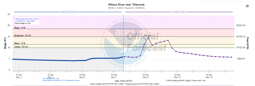
EDITOR’S NOTE: For the current flooding, the National Weather Service is estimating that the Wilson River will reach near 15 feet – moderate flooding, as Gordon describes below. Tillamook County Public Works has placed a load of sand and sand bags at their North gate off Marolf Loop available to the public to prepare for flooding. Be sure to bring your own shovel.
- 12 – minor flooding of low lying dairy and pasture land north and east of Tillamook can be expected, particularly during high tides.
- 14 – widespread lowland and dairy land flooding begins along the Wilson River downstream of the river gage at Highway 6 mile post 6. Flooding also begins along sloughs, mainly Dougherty, north of Tillamook from Wilson River Loop Road west to Hwy 101 and along Makinster Road west of Hwy 101. Minor flooding begins in the north Tillamook business district along Hwy 101, particularly during high tide.
- 15.5 – expect widespread flooding in the north part of Tillamook along Hwy 101 from Hoquarton Slough north to the Tillamook Creamery, especially during high tides. The most noticable flood impacts are to low-lying roads and some buildings near Dougherty Slough and the lower Wilson River. Widespread flooding of low lying dairy and pasture land and some rural access roads from Wilson River Loop Road downstream to Hwy 101 and along Makinster Rd and Goodspeed Rd west of Hwy 101 can be expected as well.
- 16 – flood waters threaten the Wilson River RV Park east of Tillamook along Hwy 6. Expect flooding along Hwy 101 north of Tillamook from Hoquarton Slough north to the Tillamook Creamery, especially during high tides. The most noticable flood impacts are to low-lying roads and some buildings near Dougherty Slough and the Wilson River. Expect flooding of low lying dairy and pasture land and some rural access roads from Wilson River Loop Rd downstream to Hwy 101 and along Makinster Rd and Goodspeed Rd.
- 16.5 – expect flooding to start in the Wilson River RV park east of Tillamook. Expect flooding of low areas on Hwy 101 and Hwy 6 in and near Tillamook, along with flooding of some local roads and property from Wilson River Loop Road downstream to Makinster Rd and Goodspeed Rd.
- 17 – expect flooding of the Wilson River RV park east of Tillamook. Portions of Hwy 101 north of downtown Tillamook are likely flooded and some structures are threatened. Expect flooding of portions of several local roads, including Wilson River Loop Road, Makinster Road and Goodspeed Road. The worst of the flooding can be expected during high tides.
- 19 – expect widespread flooding in and near Tillamook, from the Hwy 6 bridge over the Wilson downstream to Hwy 101 and local roads west of Hwy 101. Flooding of the Wilson River RV park east of Tillamook is likely. Hwy 101 through the northern portion of Tillamook has historically been closed at this and higher stages. The worst of the flooding can be expected during high tides.
- 21.5 – expect widespread and damaging flooding along the Wilson River from the Hwy 6 bridge near mile post 6 downstream to Hwy 101 and local roads west of Hwy 101. Expect numerous road closures and flooding of homes, farms, and businesses in low areas near the Wilson River, Dougherty Slough and other sloughs north and east of Tillamook. Hwy 101 has historically been closed at river levels this high.
- 22.5 – expect flooding similar to November 2006 flood, with widespread and damaging flooding along the Wilson River from the Hwy 6 bridge near mile post 6 downstream to Hwy 101 and local roads west of Hwy 101. Flooding of the Wilson River RV Park east of Tillamook is likely. Expect numerous road closures and flooding of homes, farms, and businesses in low areas near the Wilson River, Dougherty Slough and other sloughs north and east of Tillamook. Hwy 101 historically has been closed at river levels this high.