Menu
  • Home
  • Breaking News
  • Feature
    • Arts
    • Astrology
    • Business
    • Community
    • Employment
    • Event Stories
    • From the Pioneer
    • Government
    • Letters to the Editor
    • Non Profit News
    • Obituary
    • Public Safety
    • Podcast Interview Articles
    • Pioneer Pulse Podcast: Politics, Palette, and Planet – the Playlist
  • Weather
  • Guest Column
    • Perspectives
    • Don Backman Photos
    • Ardent Gourmet
    • Kitchen Maven
    • I’ve been thinking
    • Jim Heffernan
    • The Littoral Life
    • Neal Lemery
    • View From Here
    • Virginia Carrell Prowell
    • Words of Wisdom
  • Things to do
    • Calendar
    • Tillamook County Parks
    • Tillamook County Hikes
    • Whale Watching
    • Tillamook County Library
    • SOS Community Calendar
  • About
    • Contribute
    • Advertise
    • Subscribe
    • Opt-out preferences
  • Post Submission Test
  • Search...
Menu

NATIONAL WEATHER SERVICE-Portland Office 11/17/24 UPDATE: Multiple Weather Systems to Bring Heavy Cascade Snow and a Potential Atmospheric River and Flooding Event this Week, plus Hazardous Seas, Tidal Overflow Flooding, and Breezy Winds

Posted on November 17, 2024 by Editor

Latest update from the Portland Office of the National Weather Service 11/17/24:
Multiple Weather Systems to Bring Heavy Cascade Snow and a Potential Atmospheric River and Flooding Event this Week, plus Hazardous Seas, Tidal Overflow Flooding, and Breezy Winds.
KEY POINTS
Minor tidal overflow flooding is likely for the south WA and north/central OR coast around high tides today due to the Perigean spring tides. Minor flooding will be possible in low lying areas near bays, sloughs, portions of highway 101 and the lower reaches of the coastal rivers. The greatest impacts are expected to occur around hightide this afternoon with up to one foot of water.
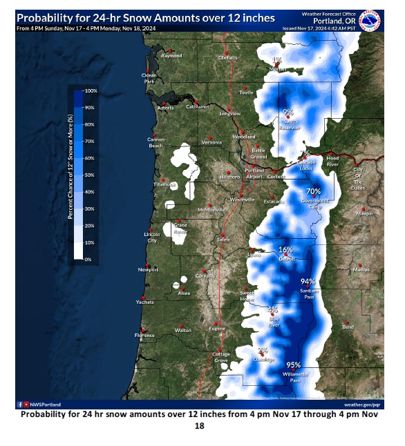
Heavy snow returns to the Cascades, including the passes, and the Coast Range this afternoon through Monday (11/17-11/18). There are high probabilities over the Cascades for 24-hr snow amounts of 12 inches or greater for elevations above 2000-3000 feet (see graphics).
Also, snow amounts of 3-12 inches are forecast for the Coast Range above 2000 feet, heaviest above 2500-3000 feet. Expect difficult travel conditions over the passes with a60-80% chance for major travel impacts.
For the lowlands, periods of heavy rain will occur with minor urban flooding possible in low-lying areas with poor drainage.

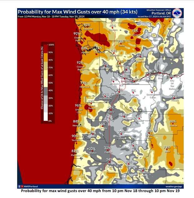
Breezy south winds continue over the area today. Forecast wind speeds are generally not strong enough for impacts beyond minor tree damage and isolated power outages, especially for inland locations. However, there is a small chance for wind gusts over 40 mph for inland areas, which would result in greater impacts (see graphics).

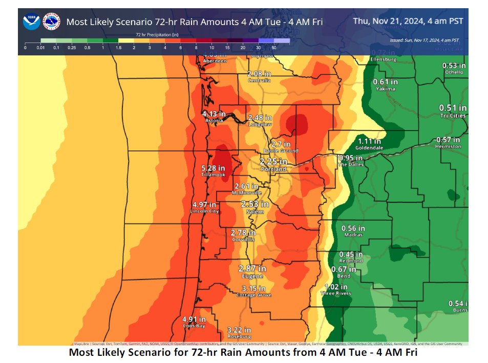
Chances have continued increasing for a prolonged atmospheric river/river flooding/urban flooding event Tuesday – late week (11/19-11/22). There will also be a threat for landslides in areas of steep terrain, as well as debris flows over/near recently burned areas if the worst-case scenario verifies. See graphics for best casescenario, most likely scenario, and worst case scenario for rain amounts. Best case scenario would suggest little tono river flooding at all, while the worst case scenario would suggest widespread river flooding with majorflooding for rivers draining the coastal mountains, as well as significant urban flooding and a high threat forlandslides and debris flows. Breezy east to southeast winds Monday night into Wednesday (11/18-11/20) which could cause tree damage and isolated power outages, especially for inland locations.
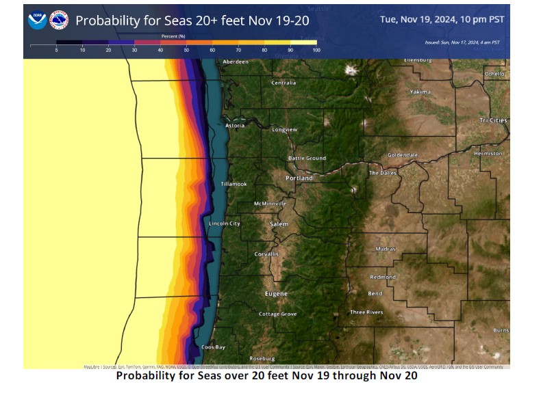
Coastal Waters: Hazardous seas expected today – Thursday (11/17-11/21) with Gale to Storm Force winds and seas most likely ranging between 14-19 feet, except 20-24 ft Tuesday night into Wednesday (11/19-11/20). Very steep and hazardous seas could capsize or cause damage to vessels.
CHANGES FROM PREVIOUS BRIEFING
• Added Major Snow risk for the Cascades above 2000 feet and Moderate Snow risk for the Coast Range above 2000 feet for tonight through Monday
• Added Minor Wind risk to the Cascades Tuesday – Wednesday (11/19-11/20) and for all other areas for Wednesday (11/20)

Featured Video

Slide Contribute SUBSCRIBE

Tillamook Weather

Tides

Tillamook County Pioneer Podcast Series

Tillamook Church Search

Cloverdale Baptist Church
Nestucca Valley Presbyterian
Tillamook Ecumenical Service

Archives

  • Home
  • EULA Privacy Policy
  • Contact
  • Opt-out preferences
  • Search...
Share on facebook
Facebook
Share on pinterest
Pinterest
Share on twitter
Twitter
Share on linkedin
Linkedin
Catherine

Recent Posts

  • LOCAL VFW POST RAISES $1,500, GETS MATCHING GRANT - $3,000 FOR LOCAL FOOD ORGANIZATIONS

    May 20, 2025
  • OREGON DEPT. OF FISH & WILDLIFE: More spring Chinook fishing days on Columbia River mainstem as run expected to come in above forecast 

    May 20, 2025
  • Check out AWARD-WINNING incredible “Coastal Futures” project on display at Rockaway Beach Library

    May 20, 2025
©2025 | Theme by SuperbThemes

Manage Cookie Consent
To provide the best experiences, we use technologies like cookies to store and/or access device information. Consenting to these technologies will allow us to process data such as browsing behavior or unique IDs on this site. Not consenting or withdrawing consent, may adversely affect certain features and functions.
Functional Always active
The technical storage or access is strictly necessary for the legitimate purpose of enabling the use of a specific service explicitly requested by the subscriber or user, or for the sole purpose of carrying out the transmission of a communication over an electronic communications network.
Preferences
The technical storage or access is necessary for the legitimate purpose of storing preferences that are not requested by the subscriber or user.
Statistics
The technical storage or access that is used exclusively for statistical purposes. The technical storage or access that is used exclusively for anonymous statistical purposes. Without a subpoena, voluntary compliance on the part of your Internet Service Provider, or additional records from a third party, information stored or retrieved for this purpose alone cannot usually be used to identify you.
Marketing
The technical storage or access is required to create user profiles to send advertising, or to track the user on a website or across several websites for similar marketing purposes.
Manage options Manage services Manage {vendor_count} vendors Read more about these purposes
View preferences
{title} {title} {title}