Menu
  • Home
  • Breaking News
  • Feature
    • Arts
    • Astrology
    • Business
    • Community
    • Employment
    • Event Stories
    • From the Pioneer
    • Government
    • Letters to the Editor
    • Non Profit News
    • Obituary
    • Public Safety
    • Podcast Interview Articles
    • Pioneer Pulse Podcast: Politics, Palette, and Planet – the Playlist
  • Weather
  • Guest Column
    • Perspectives
    • Don Backman Photos
    • Ardent Gourmet
    • Kitchen Maven
    • I’ve been thinking
    • Jim Heffernan
    • The Littoral Life
    • Neal Lemery
    • View From Here
    • Virginia Carrell Prowell
    • Words of Wisdom
  • Things to do
    • Calendar
    • Tillamook County Parks
    • Tillamook County Hikes
    • Whale Watching
    • Tillamook County Library
    • SOS Community Calendar
  • About
    • Contribute
    • Advertise
    • Subscribe
    • Opt-out preferences
  • Post Submission Test
  • Search...
Menu

OREGON DEPT. OF FORESTRY: SLASH BURNS 11/1/22

Posted on November 1, 2022November 1, 2022 by Editor

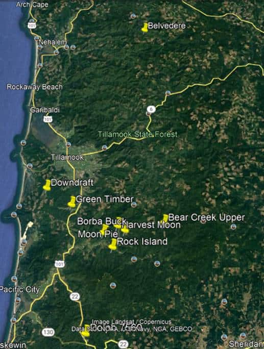
Oregon Department of Forestry – Scheduled Slash Burns in Tillamook County 11/1/22; See map below for areas/locations.

Landowner/Operator: L&C

Unit                                     Legal               Lat/Long                Acres/Tons           Est. Ignition               Location

Dolph 7560               5S 9W 28      45.1114 -123.7965     13/258          0900            23 mi S of Tillamook

Borba Buck              3S 9W 23      45.2908 -123.7503     34/672          1000            12 mi SE of Tillamook

Rock Island              3S 9W 36      45.2631 -123.2631     18/360          1100            14 mi SE of Tillamook

Harvest Moon           3S 8W 18      45.3035 -123.7126     22/432          1200            13 mi SE of Tillamook

Moon Pie                 3S 8W 20      45.2943 -123.6931     30/600          1300            13 mi SE of Tillamook

Bear Creek Upper       3S 7W 18      45.3058 -123.5889     17/342          1500            15 mi SE of Tillamook


Landowner/Operator: R.F. Wilson

Unit                                     Legal           Lat/Long                Acres/Tons           Est. Ignition               Location

LR Burn                  5S 9W 32      45.1238 -123.49       24/100          1000            10 mi SE of Hebo


Landowner/Operator: Stimson

Unit                                     Legal                          Lat/Long                Acres/Tons           Est. Ignition               Location

Belvedere                    3N 8W 13         45.731 -123.6182          103/508           1100               20 NE of Tillamook

Green Timber                3S 9W 6          45.347 -123.835           89/520            1130               8 mi S of Tillamook

Downdraft                   2S 10W 22        45.381 -123.903           36/100            1300               6 mi SW of Tillamook


Featured Video

Slide Contribute SUBSCRIBE

Tillamook Weather

Tides

Tillamook County Pioneer Podcast Series

Tillamook Church Search

Cloverdale Baptist Church
Nestucca Valley Presbyterian
Tillamook Ecumenical Service

Archives

  • Home
  • EULA Privacy Policy
  • Contact
  • Opt-out preferences
  • Search...
Share on facebook
Facebook
Share on pinterest
Pinterest
Share on twitter
Twitter
Share on linkedin
Linkedin
Catherine

Recent Posts

  • Grove avenue closed in Tillamook for maintenance

    May 10, 2025
  • Astoria Farmers Market new, outdoor location with parking, with great Riverwalk access

    May 10, 2025
  • WORDS OF WISDOM: Boycotts and Protests in our Community Garden

    May 9, 2025
©2025 | Theme by SuperbThemes

Manage Cookie Consent
To provide the best experiences, we use technologies like cookies to store and/or access device information. Consenting to these technologies will allow us to process data such as browsing behavior or unique IDs on this site. Not consenting or withdrawing consent, may adversely affect certain features and functions.
Functional Always active
The technical storage or access is strictly necessary for the legitimate purpose of enabling the use of a specific service explicitly requested by the subscriber or user, or for the sole purpose of carrying out the transmission of a communication over an electronic communications network.
Preferences
The technical storage or access is necessary for the legitimate purpose of storing preferences that are not requested by the subscriber or user.
Statistics
The technical storage or access that is used exclusively for statistical purposes. The technical storage or access that is used exclusively for anonymous statistical purposes. Without a subpoena, voluntary compliance on the part of your Internet Service Provider, or additional records from a third party, information stored or retrieved for this purpose alone cannot usually be used to identify you.
Marketing
The technical storage or access is required to create user profiles to send advertising, or to track the user on a website or across several websites for similar marketing purposes.
Manage options Manage services Manage {vendor_count} vendors Read more about these purposes
View preferences
{title} {title} {title}