Menu
  • Home
  • Feature
    • Breaking News
    • Arts
    • Astrology
    • Business
    • Community
    • Employment
    • Event Stories
    • From the Pioneer
    • Government
    • Letters to the Editor
    • Non Profit News
    • Obituary
    • Public Safety
    • Podcast Interview Articles
    • Pioneer Pulse Podcast: Politics, Palette, and Planet – the Playlist
  • Guest Column
    • Perspectives
    • Don Backman Photos
    • Ardent Gourmet
    • Kitchen Maven
    • I’ve been thinking
    • Jim Heffernan
    • The Littoral Life
    • Neal Lemery
    • View From Here
    • Virginia Carrell Prowell
    • Words of Wisdom
  • Weather
  • Post Submission
  • Things to do
    • Calendar
    • Tillamook County Parks
    • Tillamook County Hikes
    • Whale Watching
    • Tillamook County Library
    • SOS Community Calendar
  • About
    • Contribute
    • Advertise
    • Subscribe
    • Opt-out preferences
  • Search...
Menu

Thursday, November 30, 2023 Weather by Gordon McCraw

Posted on November 30, 2023November 30, 2023 by Cara Mico, Assistant Editor

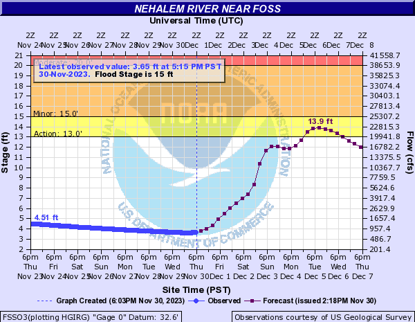
EDITOR’S NOTE: Update – 6:30 pm – the predictions have changed considerably since this morning’s report. See above for the latest on the the Nehalem River, now predicted to go above flood stage. We will have an additional information tomomrrow, Friday December 1, 2023.

By Gordon McCraw

The pattern change has started! We had the first in a series of systems bring in some mainly light rain this morning as it pushes eastward. We can expect to see the rain continue tonight with the winds becoming southerly 8-12 gusting to 18, tonight’s low temperature around 39.

It looks like we will see an atmospheric river develop and push in some rain starting tomorrow morning in the form of showers with possible thunderstorms. It will also usher in some stronger westerly winds of 14-18 gusting to 30, the high up near 52. We see more of the same tomorrow night, then just before midnight, another system pushes in another round of rain, the winds shifting to southerly 15-20 gusting to 35, lows near 43. Rainfall totals for Friday could reach 1” to 2”, especially in the Coast Range. Thankfully, the river levels are low at this point so the hydrological concerns here are low.

The concern does increase some over the weekend as it looks like the rain will continue Saturday and Sunday as another atmospheric river impacts the area. This will increase the flow rates, further increasing the river levels, but all should still stay well below Action and Flood Stage. Winds will still be elevated also with gusts Sunday as high as 35-40, with periods of heavy rain that could cause Urban and Small Stream Flooding also.

To add to the wetness, the models are suggesting a third atmospheric river moves in for the start of next week, but they don’t all agree on exactly where the hose, or area of highest rainfall, will be located. As we have learned over the years of forecasting for the coast, on Mother Natures map, 70 miles north or south is nothing, but along the coast it can make the difference between high river levels, or flooding river levels. What we can say for sure is Monday on through midweek will be rainy, possibly heavy at times, and breezy to windy. The National Weather Service folks say there is a 10-20% chance of River Flooding north of Lincoln City. I will say the latest Nehalem River Forecast has actually lowered the crest level by around 2’ over the previous Forecasts. The best guidance I can offer at this time is to start thinking about your flooding plans in case the guidance changes for the worse, especially if you live or work in flood prone areas or would need to travel through those flood prone areas. It is always better to develop a plan ahead of an incident than to try to make a plan during the incident. It is definitely time to keep a closer eye on the forecasts, including the River Level Forecasts!

Listen to the report here:


  • Weather
  • Slide Slide Slide Slide Slide Slide Slide Slide Subscribe Contribute

    Ads

    Featured Video

    Tillamook Weather

    Tides

    Tillamook County Pioneer Podcast Series

    Tillamook Church Search

    Cloverdale Baptist Church
    Nestucca Valley Presbyterian
    Tillamook Ecumenical Service

    Archives

    • Home
    • EULA Privacy Policy
    • Contact
    • Opt-out preferences
    • Search...
    Share on facebook
    Facebook
    Share on pinterest
    Pinterest
    Share on twitter
    Twitter
    Share on linkedin
    Linkedin
    Catherine

    Recent Posts

    • ROCKAWAY BEACH READIES FOR JULY 4TH FESTIVITIES - HONORS VOLUNTEER OF YEAR & PARADE GRAND MARSHAL

      June 30, 2025
    • NEWS UPDATE FROM STATE REPRESENTATIVE DAVID GOMBERG: It's a Session Wrap!

      June 30, 2025
    • GORDON'S WEEKLY WEATHER UPDATE 6/30/25: Back to Normal Summer Weather This Week - Fair, Dry & Mild; Holiday Weekend Weather Looks Good

      June 30, 2025
    ©2025 | Theme by SuperbThemes

    Manage Cookie Consent
    To provide the best experiences, we use technologies like cookies to store and/or access device information. Consenting to these technologies will allow us to process data such as browsing behavior or unique IDs on this site. Not consenting or withdrawing consent, may adversely affect certain features and functions.
    Functional Always active
    The technical storage or access is strictly necessary for the legitimate purpose of enabling the use of a specific service explicitly requested by the subscriber or user, or for the sole purpose of carrying out the transmission of a communication over an electronic communications network.
    Preferences
    The technical storage or access is necessary for the legitimate purpose of storing preferences that are not requested by the subscriber or user.
    Statistics
    The technical storage or access that is used exclusively for statistical purposes. The technical storage or access that is used exclusively for anonymous statistical purposes. Without a subpoena, voluntary compliance on the part of your Internet Service Provider, or additional records from a third party, information stored or retrieved for this purpose alone cannot usually be used to identify you.
    Marketing
    The technical storage or access is required to create user profiles to send advertising, or to track the user on a website or across several websites for similar marketing purposes.
    Manage options Manage services Manage {vendor_count} vendors Read more about these purposes
    View preferences
    {title} {title} {title}