")

By Gordon McCraw, Tillamook County Emergency Management
Wednesday, December 8, 2021, 11:00am
Earthquakes
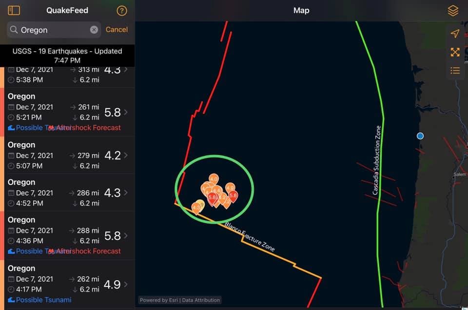
I thought I would start this update with the answers to the most asked question this morning, “What is with the earthquakes off the Oregon Coast?” Well, in case you haven’t heard, there have been a large number of 5.0+ and smaller earthquakes yesterday, and more this morning, about 250 miles west of Newport. These quakes are occurring on the Blanco Fault Zone and are not part of the Cascadia Subduction Zone. I have in the past years seen quakes in this area exceeding 6.0 in magnitude. These quakes are NOT connected to “the Big One” and do not increase the likelihood that the “Big One” is about to happen.
The Blanco Fracture Zone forms the boundary between the Pacific Place and the Juan de Fuca plates. This is well west of where the Juan de Fuca plate dives under the North America Plate that actually forms the Cascadia Subduction Zone. The risk of a Subduction Zone Slip is not increased as a result of these quakes.
This fault is best described as being similar to the faults like the San Andreas Fault, this one is a Transform Fault and usually provides little motion and when they do, the motion is not the type that usually causes tsunamis, plus they are not big enough to cause one anyway. If they were to have one above a 7.0 it might generate a tiny, nearly non-detectable tsunami, especially with our normal higher seas. Combine this with the distance away from the coast and you can see why they are seldom even felt anywhere along the coast.
So, the bottom line, we often see these clusters along this fault line, and this is but another in the series of clusters. More importantly, this does not increase the likelihood of the Cascadia Subduction Zone rupturing.
Weather
So, it looks like this cooler and wetter weather will hang around a while. Today we have a weak cold front that moved thru that gave us a little rain and will help to keep us on the cooler side as well as lower the snow level down to around 2500’. The temperature last night was around 50 but has since fallen to 46 and will likely not climb much, if any, the rest of today. We can continue to see periods of mainly light rain today with northwesterly winds 5-10. Tonight, we have another disturbance that will bring in more rain and push the snow level down to around 1900’, possibly lower in heavier showers. There is also a chance of snow in the higher passes in the early morning hours as the temperature falls up there to below freezing. This means black ice is also a concern in the early morning hours across the top. Temperatures west of the Coast Range in the mid 30s tonight.
The rain continues tomorrow and there is a chance the Coast Range passes will see snow in the early afternoon as the snow level continues to fall to around 1500-1800’, and there is a slight chance of afternoon thunderstorms. The afternoon becomes breezy with westerly winds 10-15 gusting to 25, the high near 46. Showers and possible thunderstorms continue tomorrow night until approaching midnight when the rain returns, the snow level around 2500’, overnight lows near 37. It is still possible the tops of the higher passes could see some snow in the showers that drag down the snow level, and depending on the temperatures, patchy ice is also a concern.
Friday starts out with lighter rain, but we are expecting a strong pacific front to bring rain and winds back into the area starting late Friday night into Saturday. This system appears to bring us high, possibly damaging winds to the coast Saturday with gusts possibly in the 60-70 range with a couple of the models showing 70-80 range. Add to this the system will bring down the snow levels to 1600-2100’ again. The system also has some potential to bring periods of heavy rain and a couple models slow the system. The river forecast models keep the rivers 4’ or so below even Action Stage but if the system slows, the forecast would change, something to watch.
Sunday on, the active pattern continues with clouds and rain each day, highs in the mid 40s, lows in the mid 30s. The snow level likely remains around 2000-2500’ though it could be lowering the start of next week. Traveler will want to keep an eye on the weather and at tripcheck.com. If your travel plans take you across the Coast Range know before you go and if your travel plans include the Cascades, they will likely be under Winter type Watches and Warning for snow.