Tillamook County Pioneer

News & People of Tillamook County. Every Day.

Menu
  • Home
  • Feature
    • Breaking News
    • Arts
    • Astrology
    • Business
    • Community
    • Employment
    • Event Stories
    • From the Pioneer
    • Government
    • Letters to the Editor
    • Non Profit News
    • Obituary
    • Public Safety
    • Podcast Interview Articles
    • Pioneer Pulse Podcast: Politics, Palette, and Planet – the Playlist
  • Guest Column
    • Perspectives
    • Don Backman Photos
    • Ardent Gourmet
    • Kitchen Maven
    • I’ve been thinking
    • Jim Heffernan
    • The Littoral Life
    • Neal Lemery
    • View From Here
    • Virginia Carrell Prowell
    • Words of Wisdom
    • Chuck McLaughlin – 1928 to 2025
  • Weather
  • Post Submission
  • Things to do
    • Calendar
    • Tillamook County Parks
    • Tillamook County Hikes
    • Whale Watching
    • Tillamook County Library
    • SOS Community Calendar
  • About
    • Contribute
    • Advertise
    • Subscribe
    • Opt-out preferences
  • Search...
Menu

TILLAMOOK COUNTY EMERGENCY MANAGEMENT: NATIONAL WEATHER SERVICE FORECAST 10/24/25

Posted on October 24, 2025October 24, 2025 by Editor

National Weather Service
National Oceanic and Atmospheric Administration
Weather Forecast Office Portland
Friday, Oct 24, 2025

Potential for High Winds Oct. 24-26 with Heavy Rain Oct. 24
KEY POINTS
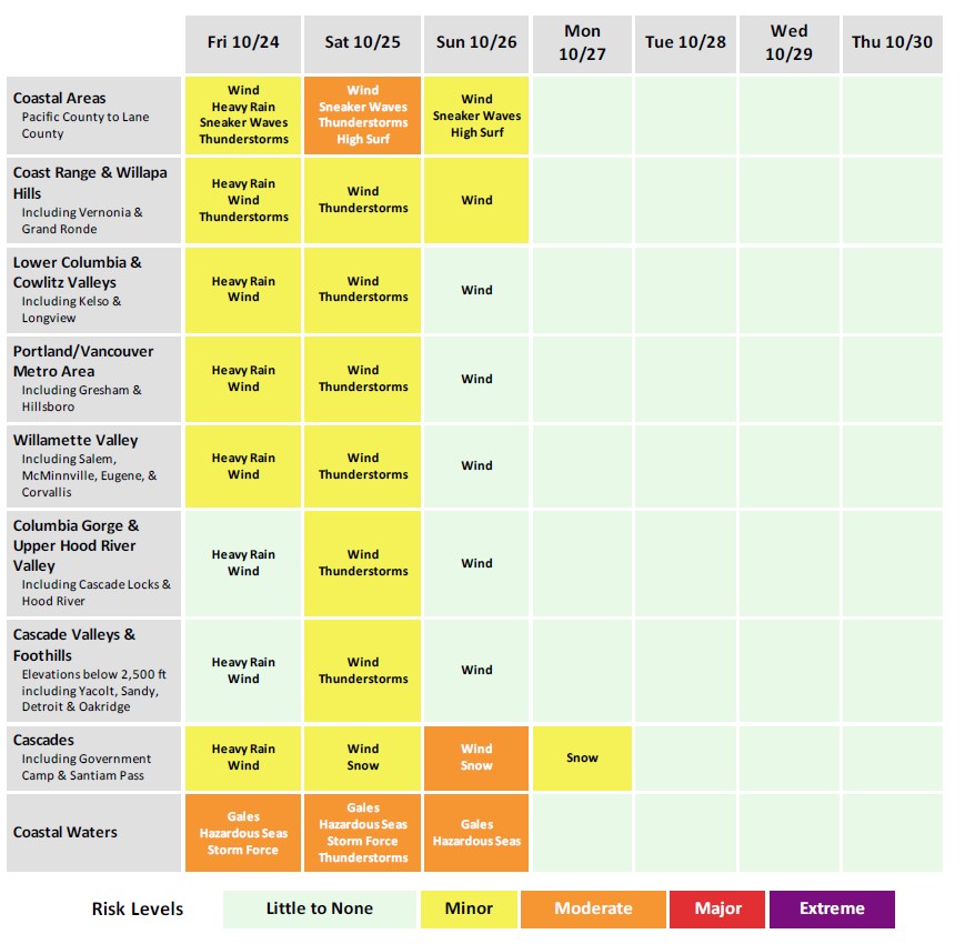
• A moderate atmospheric river and quick-following low pressure system brings multiple rounds of widespread rain and chances for high winds across northwest Oregon, southwest Washington, and the coastal waters Oct. 23-26.
• Inland: 20-30% chance for a moderate impact wind event (mainly Saturday) with max wind gusts over 45 mph for inland areas. However, less than a ~10% chance for a high impact wind event with max wind gusts over 55 mph for inland areas.
• Coast: 45-80% chance for a moderate impact wind event with max wind gusts over 45 mph for coastal areas (Friday and Saturday, Oct 24-25) and a 50-70% chance for a high impact wind event with max wind gusts over 55 mph (mainly Saturday, Oct 25).
• Highest winds overall expected on Oct. 25. If wind gusts around the moderate (>45 mph) to high (>55 mph) impact level do materialize, widespread tree damage and power outages would occur.


• Coastal waters: 10-35% chance for storm force wind gusts of 48 kt or stronger into Friday morning (Oct 24). Probabilities for Storm Force wind gusts closer to 40-65% on Saturday, Oct 25. The highest probabilities for both periods of time are over the northern Oregon and southern Washington inner waters.
• Heavy rainfall rates may cause flooding of urban, low-lying, or other poor-drainage areas. There is a 25% chance rainfall rates exceed 0.25″ per hour Friday afternoon and evening (12 PM Oct 24 to 12 AM Oct 25), a rate threshold that typically corresponds to nuisance flooding or widespread ponding on roadways. There is also a 15% chance rainfall rates exceed 0.5″ per hour, most likely from 5-10 PM Friday evening (Oct 24). This rate threshold corresponds to more severe urban flooding of areas which are not typically inundated during more typical rain events. These elevated rainfall rates are equally likely in more rural areas, however impacts on the ground would likely be lessened.
• River flooding is unlikely (<5% chance), as river levels are currently at or near their annual minimum and should be able to handle the expected runoff.
• Coast: Seas of 20-25 ft expected Saturday into Sunday morning. Breakers of 30 ft likely during this time.
• Moderate to high Sneaker Wave threat likely continues through the weekend. Sneaker waves can suddenly knock people off of their feet and quickly pull them into the ocean which may lead to serious injury or drowning.
• Make sure to secure outdoor items which could be blown away by strong winds. Clear your gutters and drains of leaves and other debris to ensure proper drainage during heavy rain.
• Travel impacts from snow in the Cascades are not expected Thursday night-Friday (Oct 23-24), as snow levels will likely be above the passes (70-90% chance). Snow levels likely fall to 3500-4500 ft Saturday night into Sunday (Oct 25-26), bringing accumulating snow at pass level with over 6 inches of snow likely at pass level (80-90% chance).

OR MORE INFORMATION
Forecast resources: https://www.weather.gov/pqr/briefing
Probability Graphic:
https://www.weather.gov/pqr/wintersummerlanding
IDSS Forecast Point https://www.weather.gov/pqr/wintersummerlanding
Graphical Forecasts: https://digital.weather.gov/
River Forecasts: http://water.noaa.gov/wfo/pqr
Latest Forecast Discussion:
https://www.weather.gov/wrh/TextProduct?product=afdpqr
National Weather Service – Portland
weather.gov/US National Weather Service Portland Oregon

Slide Slide Slide Slide Slide Slide Slide Slide Subscribe Contribute

Ads

Featured Video

Tillamook Weather

Tides

Tillamook County Pioneer Podcast Series

Tillamook Church Search

Cloverdale Baptist Church
Nestucca Valley Presbyterian
Tillamook Ecumenical Service

Archives

  • Home
  • EULA Privacy Policy
  • Contact
  • Opt-out preferences
  • Search...
Share on facebook
Facebook
Share on pinterest
Pinterest
Share on twitter
Twitter
Share on linkedin
Linkedin
Catherine

Recent Posts

  • OREGON DEPT. OF FISH & WILDLIFE: Mussel harvest reopens from Cascade Head to the California border

    October 24, 2025
  • TRAILKEEPERS, ORGANIZATIONS, COMMUNITY VOLUNTEERS CELEBRATE COMPLETION OF SHORT BEACH TRAIL STAIRS IN OCEANSIDE

    October 24, 2025
  • Social Security Announces 2.8 Percent Benefit Increase for 2026

    October 24, 2025
©2025 Tillamook County Pioneer | Theme by SuperbThemes

Manage Cookie Consent
To provide the best experiences, we use technologies like cookies to store and/or access device information. Consenting to these technologies will allow us to process data such as browsing behavior or unique IDs on this site. Not consenting or withdrawing consent, may adversely affect certain features and functions.
Functional Always active
The technical storage or access is strictly necessary for the legitimate purpose of enabling the use of a specific service explicitly requested by the subscriber or user, or for the sole purpose of carrying out the transmission of a communication over an electronic communications network.
Preferences
The technical storage or access is necessary for the legitimate purpose of storing preferences that are not requested by the subscriber or user.
Statistics
The technical storage or access that is used exclusively for statistical purposes. The technical storage or access that is used exclusively for anonymous statistical purposes. Without a subpoena, voluntary compliance on the part of your Internet Service Provider, or additional records from a third party, information stored or retrieved for this purpose alone cannot usually be used to identify you.
Marketing
The technical storage or access is required to create user profiles to send advertising, or to track the user on a website or across several websites for similar marketing purposes.
Manage options Manage services Manage {vendor_count} vendors Read more about these purposes
View preferences
{title} {title} {title}