Event Description: High Wind Warning
Alert: High Wind Warning from 4 pm this afternoon (Dec. 19th) until 04:00PM Friday
Severity: Severe – Significant threat to life or property
Urgency: Expected – Responsive action SHOULD be taken soon (within next hour)
Certainty: Likely (p > ~50%)
Category: Meteorological (inc. flood)
* WHAT…South winds 35 to 45 mph with gusts up to 65 mph expected near beaches and headlands.
* WHERE…Beaches and headlands along the North and Central Coast of Oregon.
* WHEN…From 4 PM this afternoon to 8 AM PST Friday.
* IMPACTS…Travel will be difficult, especially for high profile vehicles. Strong winds may blow down tree limbs and power lines, potentially leading to scattered power outages.
* ADDITIONAL DETAILS…Coastal headlands are characterized by high, rocky shores and steep sea cliffs.
* AFFECTED AREAS: NORTH OREGON COAST … CENTRAL OREGON COAST
Instructions:
Residents should take action now to tie down loose objects in yards. Some damage can be expected from the high winds, especially to signs, tree limbs and power lines. Power outages are possible. Drive with extreme caution in the warning area and be prepared for flying debris.
FLOOD WATCH – December 18, 2019
Alert Details
Severity: Severe – Significant threat to life or property
Urgency: Future – Responsive action SHOULD be taken in the near future
Certainty: Possible (p <= ~50%)
Category: Meteorological (inc. flood)
Event Description: Flood Watch
Advisory: Flood Watch until 10:00AM Sunday
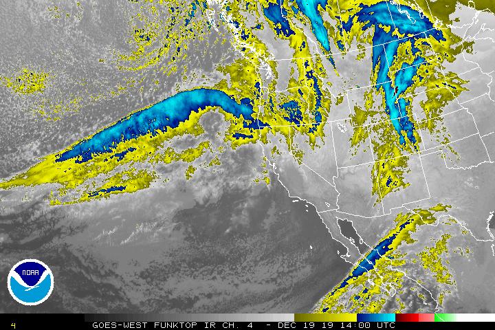
...HEAVY RAIN THURSDAY NIGHT THROUGH FRIDAY NIGHT WILL LIKELY CAUSE SOME MINOR FLOODING OF CREEKS AND RIVERS... .Heavy rain Thursday night through Friday night may result in flooding of creeks and rivers. The areas of most concern are creeks and rivers draining the Coast Range and Willapa Hills, along with the south Washington and North Oregon Cascades foothills. Localized flooding could also affect inland valleys all the way from Longview to Eugene. The National Weather Service in Portland has issued a
* Flood Watch for portions of Northwest Oregon and Southwest Washington, including the following areas, in Northwest Oregon, Central Coast Range of Western Oregon, Central Oregon Coast, Central Willamette Valley, Coast Range of Northwest Oregon, Greater Portland Metro Area, Lower Columbia, North Oregon Coast, Northern Oregon Cascade Foothills, South Willamette Valley, and Western Columbia River Gorge. In Southwest Washington, Greater Vancouve r Area, I-5 Corridor in Cowlitz County, South Washington Cascade Foothills, South Washington Coast, Western Columbia River Gorge, and Willapa Hills.
* From Thursday evening through Sunday morning
* Heavy rain Thursday night through Friday night will cause sharp rises on many creeks and rivers. The heaviest rain will be in the Coast Range and Willapa Hills, along with the south Washington and north Oregon Cascade foothills, with totals of 3 to 8 inches. Amounts for inland locations, including Longview, Portland, Salem, and Eugene, will be 2 to 4 inches. Creek and river flooding is possible starting early Friday morning. Slower-responding rivers won't see a flood threat until Saturday or Sunday.
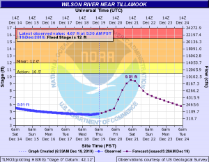
* There is still low confidence in which rivers will be most affected, but the rivers of greatest concern based on the latest forecasts include the Grays in Wahkiakum County, the Siletz and Alsea in Lincoln County, and the Luckiamute in Polk and Benton Co unties. Johnson Creek in the Portland metro area is also forecast to crest near flood stage. Any river flooding is expected to be minor.
* Flooding of creeks and flood-prone roads in both urban and rural areas could affect travel Thursday night through Saturday.
* AFFECTED AREAS: NORTH OREGON COAST ... NORTHERN OREGON CASCADE FOOTHILLS ... WESTERN COLUMBIA RIVER GORGE ... LOWER COLUMBIA AND I - 5 CORRIDOR IN COWLITZ COUNTY ... CENTRAL COAST RANGE OF WESTERN OREGON ... WILLAPA HILLS ... WESTERN COLUMBIA RIVER GORGE ... SOUTH WASHINGTON COAST ... CENTRAL OREGON COAST ... COAST RANGE OF NORTHWEST OREGON ... GREATER PORTLAND METRO AREA ... GREATER VANCOUVER AREA ... LOWER COLUMBIA ... CENTRAL WILLAMETTE VALLEY ... SOUTH WASHINGTON CASCADE FOOTHILLS ... SOUTH WILLAMETTE VALLEY
Instructions:
A Flood Watch means there is a potential for flooding based on current forecasts. You should monitor later forecasts and be alert for possible Flood Warnings. Those living in areas prone to flooding should be prepared to take action should flooding develop. Landslides and debris flows are possible during this flood event. People, structures and roads located below steep slopes, in canyons, and near the mouths of canyons may be at serious risk from rapidly moving landslides.