Menu
  • Home
  • Feature
    • Breaking News
    • Arts
    • Astrology
    • Business
    • Community
    • Employment
    • Event Stories
    • From the Pioneer
    • Government
    • Letters to the Editor
    • Non Profit News
    • Obituary
    • Public Safety
    • Podcast Interview Articles
    • Pioneer Pulse Podcast: Politics, Palette, and Planet – the Playlist
  • Guest Column
    • Perspectives
    • Don Backman Photos
    • Ardent Gourmet
    • Kitchen Maven
    • I’ve been thinking
    • Jim Heffernan
    • The Littoral Life
    • Neal Lemery
    • View From Here
    • Virginia Carrell Prowell
    • Words of Wisdom
  • Weather
  • Post Submission
  • Things to do
    • Calendar
    • Tillamook County Parks
    • Tillamook County Hikes
    • Whale Watching
    • Tillamook County Library
    • SOS Community Calendar
  • About
    • Contribute
    • Advertise
    • Subscribe
    • Opt-out preferences
  • Search...
Menu

GAM WEATHER: Tillamook Area Forecast – Wednesday Jan. 29th, 7:15 am

Posted on January 29, 2020January 29, 2020 by Editor


By Gordon McCraw, GAM Weather
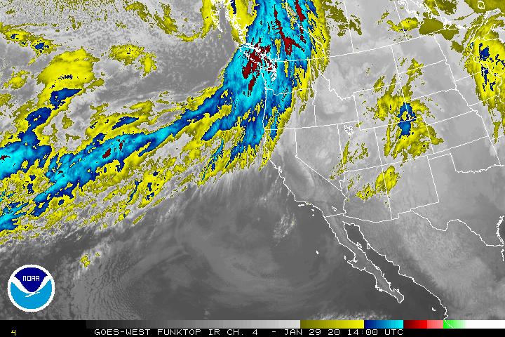
Another day and another front. Today we have a warm front causing light rain this morning then a cold front will push thru this afternoon with a quick burst of heavier rain. Winds become southerly 10-15 gusting to 30, the high near 53. The rain eases later tonight with a 50% chance still after midnight. We expect light winds tonight, maybe some patchy fog, lows near 44.

This burst of rain which delivers another 3/4 to 1″ of rain will push the rivers up once again but the river forecasts only show the Grays River getting up near Flood Stage again, the Nehalem river is still just below Action stage so this could push it up into Action again. The other rivers have decreased sufficiently enough that they will likely stay below Action Stage with this one.
Another low pressure area caught in the flow from a larger low pressure area over the Gulf of Alaska will rotate up into the area tomorrow, Thursday Jan. 30th, causing today’s cold front to lift northward tomorrow. The good news is this will not have as much moisture associated still, good for us!
Friday January 31st, it looks like another Atmospheric River event sets up over Washington and/or Vancouver Island but some of the moisture will still make it through our area so more rain with breezy conditions Friday.

A cold front drifts south through the area Saturday, February 1st, turning to scattered showers behind the front Saturday night. This also pushes the temperatures and the snow level down into Sunday when the highs are around 47, the lows near 38 with breezy conditions still. The snow level lowers to around 1000’ by midnight.

Still a slight chance of showers Monday, February 3rd, the high near 47, the snow level 1000-1500” but dropping Monday night from around 900’ down to near 400’ with the lows down near 36. At a minimum we can expect some frost Tuesday morning though there is a slight chance of lower level mixed precipitation or flurries. The snow level will be rising during the day to around 1500-2000’, the afternoon high near 49.

For more – www.gamweather.com

Slide Slide Slide Slide Slide Slide Slide Slide Subscribe Contribute

Ads

Featured Video

Tillamook Weather

Tides

Tillamook County Pioneer Podcast Series

Tillamook Church Search

Cloverdale Baptist Church
Nestucca Valley Presbyterian
Tillamook Ecumenical Service

Archives

  • Home
  • EULA Privacy Policy
  • Contact
  • Opt-out preferences
  • Search...
Share on facebook
Facebook
Share on pinterest
Pinterest
Share on twitter
Twitter
Share on linkedin
Linkedin
Catherine

Recent Posts

  • OREGON DEPT. OF FISH & WILDLIFE SHELLFISH ALERT: Mussel harvest closure Tillamook Head (South of Seaside) to north Jetty of the Siuslaw River

    June 27, 2025
  • PORT OF GARIBALDI: South Jetty Project Update from U.S. Army Corp of Engineers

    June 27, 2025
  • OREGON STATE POLICE: FATAL CRASH - HIGHWAY 101 - CLATSOP COUNTY, THURSDAY, JUNE 26, 2025

    June 27, 2025
©2025 | Theme by SuperbThemes

Manage Cookie Consent
To provide the best experiences, we use technologies like cookies to store and/or access device information. Consenting to these technologies will allow us to process data such as browsing behavior or unique IDs on this site. Not consenting or withdrawing consent, may adversely affect certain features and functions.
Functional Always active
The technical storage or access is strictly necessary for the legitimate purpose of enabling the use of a specific service explicitly requested by the subscriber or user, or for the sole purpose of carrying out the transmission of a communication over an electronic communications network.
Preferences
The technical storage or access is necessary for the legitimate purpose of storing preferences that are not requested by the subscriber or user.
Statistics
The technical storage or access that is used exclusively for statistical purposes. The technical storage or access that is used exclusively for anonymous statistical purposes. Without a subpoena, voluntary compliance on the part of your Internet Service Provider, or additional records from a third party, information stored or retrieved for this purpose alone cannot usually be used to identify you.
Marketing
The technical storage or access is required to create user profiles to send advertising, or to track the user on a website or across several websites for similar marketing purposes.
Manage options Manage services Manage {vendor_count} vendors Read more about these purposes
View preferences
{title} {title} {title}