By Gordon McCraw, Meteorologist for the Tillamook County Pioneer
Tuesday, March 7, 2023
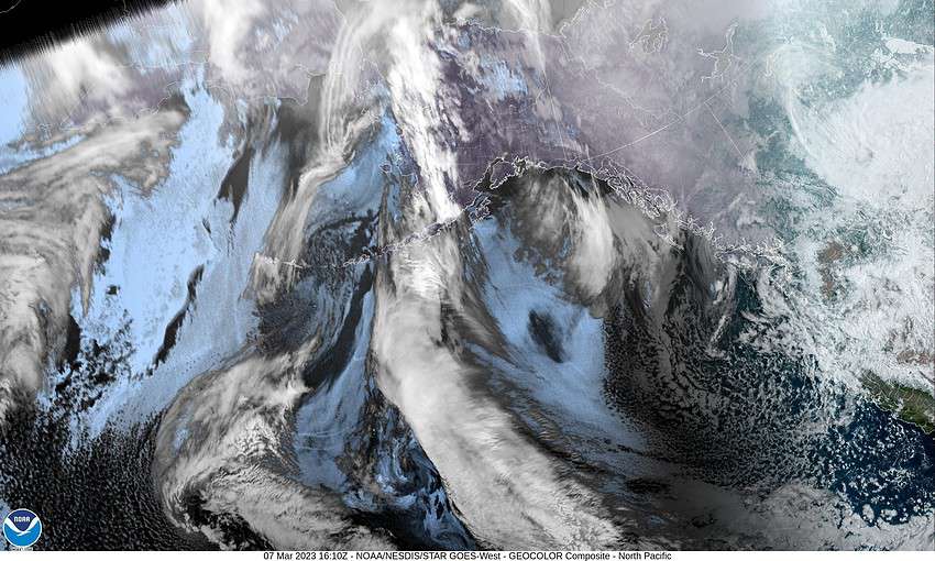
Several things happening off the coast are driving our weather today. We have a trough of low pressure off the coast, extending from Vancouver Island down to Northern California. Within the trough, there are low pressure areas being spun up in the flow that ride in on the flow then move up the coast, causing rain, and in some cases, low level snow in the area. We had one low yesterday that gave us some showers before it moved on off to the north to Vancouver Island. Today, we see another low pressure area spinning west of Oregon. With some instability lingering over the area, and then adding daytime heating we will see an uptick in the afternoon and evening shower activity again today.
So, tonight’s forecast is for showers with a slight chance of thunderstorms with small hail possible in the heavier showers as the low pressure center moves inland. Winds tonight easterly 4-8, and the snow level falling from 1400’ down to near 400’ after midnight with low level snow possible as the low temperature drops to near 32. In these conditions, you generally see little to no accumulation.
Tomorrow, we start out with the showers that could be low level snow showers that turn to all rain by midmorning, and the snow level lifts to 1500’ in the afternoon. Winds tomorrow southerly 5-10, the high near 46. The low pressure area strengths some causing more showers tomorrow night and the winds increase, becoming southeasterly 15-20 gusting to 30, the low near 35, the snow level up near 1500’.
The latest models now show another low pressure area drifting eastward toward our coast as an atmospheric river sets up to the south, towards the Oregon/California border Thursday into Friday. It appears the atmospheric river will get pushed southward as the low pressure area builds west of our area. The low does pull in some of the moisture to its south, and we likely see increasing rain along the coast and Coast Range. It does look like the heaviest rain will remain just offshore but still close enough that if the models are just a little off, and the band sets up further east, like over our area, we could see some increasing flooding concerns from the rain runoff with the snow melt all running into a particular watershed.
Okay, so Thursday we see some moderate rain, wind southeasterly 15-20 gusting to 30, the high up near 46, the snow level lifting to near 2000’ by the afternoon. Rainy and windy conditions expected for Thursday night, the lows near 36.
Look for more rain Friday as the low pressure area moves northward, still breezy, highs near 47, the snow level now up near 2600’, more of the same that night as the low moves inland to the north, lows near 37.
The models are mixed after Friday. Now some are showing conditions changing that would potentially set up another atmosphere river event somewhere along coastal Oregon or Washington with heavy rain possible by Monday and Tuesday. For now, the weekend looks rainy and breezy at times, highs warming to around 50, lows near 38.
As for Monday and Tuesday, stay tuned! It wouldn’t hurt anything to dust off, then review and discuss your plans should flooding develop, especially if you live or work in a flood-prone area. The river forecasts do not show any flooding at this time but as you know, this can change as the event gets closer. For now, we say there is a chance someone could see moderate to heavy rains, that cause a flooding risk, somewhere between Vancouver Island and Northern California. How’s that for broad!
Remember, Sunday March 12th – Spring Ahead to Daylight Savings!