Menu
  • Home
  • Feature
    • Breaking News
    • Arts
    • Astrology
    • Business
    • Community
    • Employment
    • Event Stories
    • From the Pioneer
    • Government
    • Letters to the Editor
    • Non Profit News
    • Obituary
    • Public Safety
    • Podcast Interview Articles
    • Pioneer Pulse Podcast: Politics, Palette, and Planet – the Playlist
  • Guest Column
    • Perspectives
    • Don Backman Photos
    • Ardent Gourmet
    • Kitchen Maven
    • I’ve been thinking
    • Jim Heffernan
    • The Littoral Life
    • Neal Lemery
    • View From Here
    • Virginia Carrell Prowell
    • Words of Wisdom
  • Weather
  • Post Submission
  • Things to do
    • Calendar
    • Tillamook County Parks
    • Tillamook County Hikes
    • Whale Watching
    • Tillamook County Library
    • SOS Community Calendar
  • About
    • Contribute
    • Advertise
    • Subscribe
    • Opt-out preferences
  • Search...
Menu

GORDON’S UPDATE: Weather 7/28/23 – “Dog Days” of Summer Continue …

Posted on July 28, 2023 by Editor

By Gordon McCraw, Meteorologist for the Tillamook County Pioneer

I continue to talk about the low pressure area west of British Columbia that is still forecast to drift south towards Vancouver Island by tomorrow. With a ridge still east of the state, we would see the upper level flow turn more southwesterly tonight. This in turn would give us less overnight cloudiness so we should have partly cloudy skies tonight with light winds, the low near 52.

Tomorrow brings another mostly sunny day with afternoon westerly winds 8-12, the high near 69, then another partly cloudy night, the winds becoming light and variable, lows near 53. The pattern will change little so Sunday is looking sunny with those westerly winds 5-10, the high near 68, and mostly clear skies Sunday night, lows near 52.

Next week, it looks like the ridge to the east will build stronger and start to influence our weather with clearing skies and slightly warmer temperatures. So, Monday and Tuesday look sunny with high temperatures around 71, mostly clear nights, lows near 53. The models do suggest some gusty winds Tuesday night though.

Still not much change Wednesday or Thursday with mostly sunny skies expected, the high near 70, partly cloudy nights, lows near 54.

The “Dog Days of Summer” continue!

Earlier in the week, I mentioned the Dog Days of Summer, so, just what are the Dog Days of Summer?

Well, the “Dog Days” are the period of summer that refers to that time of particularly hot and humid weather for the Northern Hemisphere. But where did this term come from? Glad you asked!

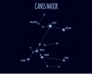
This period happens to coincide with the rising of Sirius, the Dog Star, part of the constellation Canis Majoris, the “Greater Dog”. During this period, Sirius happens to be the brightest star in the sky, well, except for our own sun of course.

In ancient times in Greece, Egypt and Rome, it was believed that the rising of the star Sirius contributed to the extreme weather of the season. It was believed that the combination of the heat from our own sun with that of Sirius was the cause of the sweltering heat. I would say that the Midwest and South might just agree with that this year. The Farmer’s Almanac considers the Dog Days to be from July 3rd through August 11th, 40 days of the worst summer heat.

There are other superstitions associated with this period also. I will end with a verse from the Old-Timers:

Dog Days bright and clear
Indicate a happy year;
But when accompanied by rain,
For better times, our hopes are vain.

It looks like a “Happy Year” for us!

Slide Slide Slide Slide Slide Slide Slide Slide Subscribe Contribute

Ads

Featured Video

Tillamook Weather

Tides

Tillamook County Pioneer Podcast Series

Tillamook Church Search

Cloverdale Baptist Church
Nestucca Valley Presbyterian
Tillamook Ecumenical Service

Archives

  • Home
  • EULA Privacy Policy
  • Contact
  • Opt-out preferences
  • Search...
Share on facebook
Facebook
Share on pinterest
Pinterest
Share on twitter
Twitter
Share on linkedin
Linkedin
Catherine

Recent Posts

  • ROCKAWAY BEACH READIES FOR JULY 4TH FESTIVITIES - HONORS VOLUNTEER OF YEAR & PARADE GRAND MARSHAL

    June 30, 2025
  • NEWS UPDATE FROM STATE REPRESENTATIVE DAVID GOMBERG: It's a Session Wrap!

    June 30, 2025
  • GORDON'S WEEKLY WEATHER UPDATE 6/30/25: Back to Normal Summer Weather This Week - Fair, Dry & Mild; Holiday Weekend Weather Looks Good

    June 30, 2025
©2025 | Theme by SuperbThemes

Manage Cookie Consent
To provide the best experiences, we use technologies like cookies to store and/or access device information. Consenting to these technologies will allow us to process data such as browsing behavior or unique IDs on this site. Not consenting or withdrawing consent, may adversely affect certain features and functions.
Functional Always active
The technical storage or access is strictly necessary for the legitimate purpose of enabling the use of a specific service explicitly requested by the subscriber or user, or for the sole purpose of carrying out the transmission of a communication over an electronic communications network.
Preferences
The technical storage or access is necessary for the legitimate purpose of storing preferences that are not requested by the subscriber or user.
Statistics
The technical storage or access that is used exclusively for statistical purposes. The technical storage or access that is used exclusively for anonymous statistical purposes. Without a subpoena, voluntary compliance on the part of your Internet Service Provider, or additional records from a third party, information stored or retrieved for this purpose alone cannot usually be used to identify you.
Marketing
The technical storage or access is required to create user profiles to send advertising, or to track the user on a website or across several websites for similar marketing purposes.
Manage options Manage services Manage {vendor_count} vendors Read more about these purposes
View preferences
{title} {title} {title}