Menu
  • Home
  • Feature
    • Breaking News
    • Arts
    • Astrology
    • Business
    • Community
    • Employment
    • Event Stories
    • From the Pioneer
    • Government
    • Letters to the Editor
    • Non Profit News
    • Obituary
    • Public Safety
    • Podcast Interview Articles
    • Pioneer Pulse Podcast: Politics, Palette, and Planet – the Playlist
  • Guest Column
    • Perspectives
    • Don Backman Photos
    • Ardent Gourmet
    • Kitchen Maven
    • I’ve been thinking
    • Jim Heffernan
    • The Littoral Life
    • Neal Lemery
    • View From Here
    • Virginia Carrell Prowell
    • Words of Wisdom
  • Weather
  • Post Submission
  • Things to do
    • Calendar
    • Tillamook County Parks
    • Tillamook County Hikes
    • Whale Watching
    • Tillamook County Library
    • SOS Community Calendar
  • About
    • Contribute
    • Advertise
    • Subscribe
    • Opt-out preferences
  • Search...
Menu

GORDON’S UPDATE: Weather 12/5/23 – Flooding continues … Travel impacts throughout county

Posted on December 5, 2023 by Editor

By Gordon McCraw, Meteorologist for the Tillamook County Pioneer

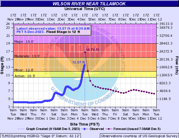
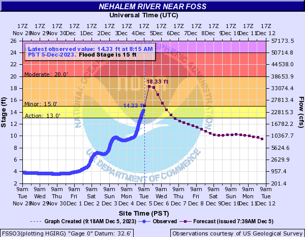
I am typing this early as it is a rather busy morning with river flooding occurring in many parts of the county, closing several roads. The current forecasts show the Nehalem River will crest this evening right at the Moderate Flood level. The Wilson and Trask Rivers look to crest around the same time into the Minor Flood levels. Down south, even the Nestucca River is forecasted to reach into the Action Stage. Obviously, these levels are subject to change as conditions change.

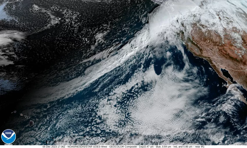
So, just as forecasted, we are in the grips of yet another atmospheric river event with the front edge south just past Newport at 9:00am while the back edge to the north is approaching the central coast area of Washington. This front/atmosphere river will continue to slowly make its way south and southeast today, adding to the 2-3” of rain Tillamook has already seen in the last 24hr, and the 3-5” already in the Coast Range. Current rainfall rates range from 0.15 to 0.25 inches per hour. The winds have also been breezy to windy with gusts in town between 30-35 and 45-50 at the beaches. This has resulted in a few power outages also.

Current river levels @9:30am

We can expect the rain to continue into the afternoon, with the rain heavy at times, along with the breezy southerly winds 14-18 gusting to 30, the high is likely now at 61. The front pushes through tonight so the rain rates ease, the winds also easing and becoming southeasterly 4-8, the low drops to near 47 tonight. Just be aware that there is a slight chance the front could stall and delay the front’s exit, we hope not because this would increase the expected flood levels across the county.

The front likely gets a push and starts to increase its speed eastward tomorrow morning with the help of an approaching upper level trough of low pressure. This would transition us to showers by the afternoon, with a chance of isolated thunderstorms. Winds becoming westerly 4-8, the high only near 54, more showers with possible thunderstorms tomorrow night, winds westerly 5-10, lows near 41.

The trough moves across Thursday so we continue to see the showers with possible thunderstorms into the evening, then we may see a short break Friday morning but then the rain returns with another breezy front that also has plenty of moisture, but for now, the models again vary on who will be under the hose for this one. So, the rain returns by Friday and persists through Saturday into Sunday with a weak ridge likely easing the rain later Sunday and Monday. The temperatures do start to lower late this week with highs around 50 and lows in the upper 30s with the snow level lowering to near 2500’ by Friday.

The important thing today is not to travel unless you have to. If you do, avoid traveling through the flood waters as you can’t be certain what is under the water or how deep it really is. Look at www.tripcheck.com before you go to see road closures. Look at www.weather.gov/Portland for the weather updates. You can see current river forecasts at https://water.weather.gov/ahps2/index.php?wfo=pqr

Lastly, we have learned over the years that the high tides aggravate flooding issues, slowing how fast the river levels can lower. Just to add additional issues during this time, the tides are currently running about 1.5’ higher than forecasted. Today the high tide times are 6:52am and at 6:19pm, tomorrow at 7:37am and again at 8:19pm.


Slide Slide Slide Slide Slide Slide Slide Slide Subscribe Contribute

Ads

Featured Video

Tillamook Weather

Tides

Tillamook County Pioneer Podcast Series

Tillamook Church Search

Cloverdale Baptist Church
Nestucca Valley Presbyterian
Tillamook Ecumenical Service

Archives

  • Home
  • EULA Privacy Policy
  • Contact
  • Opt-out preferences
  • Search...
Share on facebook
Facebook
Share on pinterest
Pinterest
Share on twitter
Twitter
Share on linkedin
Linkedin
Catherine

Recent Posts

  • ROCKAWAY BEACH READIES FOR JULY 4TH FESTIVITIES - HONORS VOLUNTEER OF YEAR & PARADE GRAND MARSHAL

    June 30, 2025
  • NEWS UPDATE FROM STATE REPRESENTATIVE DAVID GOMBERG: It's a Session Wrap!

    June 30, 2025
  • GORDON'S WEEKLY WEATHER UPDATE 6/30/25: Back to Normal Summer Weather This Week - Fair, Dry & Mild; Holiday Weekend Weather Looks Good

    June 30, 2025
©2025 | Theme by SuperbThemes

Manage Cookie Consent
To provide the best experiences, we use technologies like cookies to store and/or access device information. Consenting to these technologies will allow us to process data such as browsing behavior or unique IDs on this site. Not consenting or withdrawing consent, may adversely affect certain features and functions.
Functional Always active
The technical storage or access is strictly necessary for the legitimate purpose of enabling the use of a specific service explicitly requested by the subscriber or user, or for the sole purpose of carrying out the transmission of a communication over an electronic communications network.
Preferences
The technical storage or access is necessary for the legitimate purpose of storing preferences that are not requested by the subscriber or user.
Statistics
The technical storage or access that is used exclusively for statistical purposes. The technical storage or access that is used exclusively for anonymous statistical purposes. Without a subpoena, voluntary compliance on the part of your Internet Service Provider, or additional records from a third party, information stored or retrieved for this purpose alone cannot usually be used to identify you.
Marketing
The technical storage or access is required to create user profiles to send advertising, or to track the user on a website or across several websites for similar marketing purposes.
Manage options Manage services Manage {vendor_count} vendors Read more about these purposes
View preferences
{title} {title} {title}