Menu
  • Home
  • Breaking News
  • Feature
    • Arts
    • Astrology
    • Business
    • Community
    • Employment
    • Event Stories
    • From the Pioneer
    • Government
    • Letters to the Editor
    • Non Profit News
    • Obituary
    • Public Safety
    • Podcast Interview Articles
    • Pioneer Pulse Podcast: Politics, Palette, and Planet – the Playlist
  • Weather
  • Guest Column
    • Perspectives
    • Don Backman Photos
    • Ardent Gourmet
    • Kitchen Maven
    • I’ve been thinking
    • Jim Heffernan
    • The Littoral Life
    • Neal Lemery
    • View From Here
    • Virginia Carrell Prowell
    • Words of Wisdom
  • Things to do
    • Calendar
    • Tillamook County Parks
    • Tillamook County Hikes
    • Whale Watching
    • Tillamook County Library
    • SOS Community Calendar
  • About
    • Contribute
    • Advertise
    • Subscribe
    • Opt-out preferences
  • Post Submission Test
  • Search...
Menu

EXTRA – GORDON’S WEATHER UPDATE 2/20/25: It’s Always Something … Rain Coming

Posted on February 20, 2025 by Editor

Just a quick note from Gordon … He’ll provide a more in-depth weather forecast for the weekend (it’s going to be wet!) and into early next week.

The winter that just keeps on giving…I’ll do a more indepth forecast tomorrow. The current river forecasts don’t look bad, but are subject to change…as the event changes, as usual:

Hydrologic Outlook
National Weather Service Portland OR
246 PM PST Thu Feb 20 2025

…PERIOD OF WET WEATHER WILL LEAD TO RISES ON RIVERS AND INCREASE CHANCES FOR URBAN FLOODING…

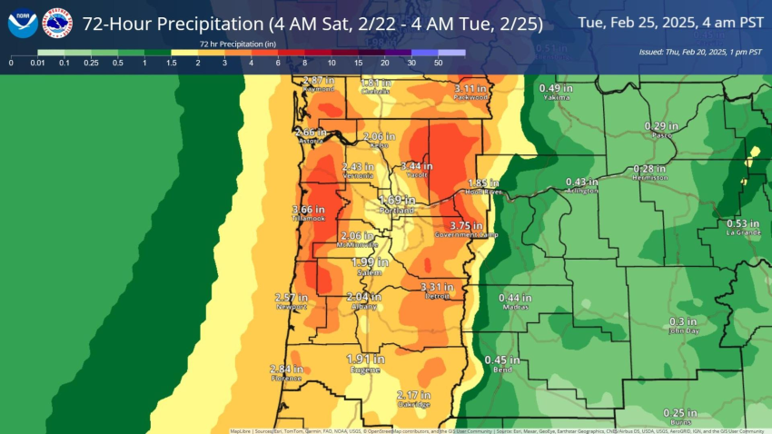
A series of frontal systems will bring heavy rainfall to northwest Oregon and southwest Washington this weekend. Rain will begin
Saturday afternoon, and intensify overnight through Sunday. This will lead to rises on rivers and creeks, especially along the coast
on February 22nd through the 23rd. Main stem rivers may be delayed to respond, and flooding may occur beyond this time frame.

There is around a 25% chance of the Wilson River, the Grays River, and other localized quick responding coastal rivers of reaching
minor flood stage on Sunday. Confidence in flooding is low as the location of heaviest precipitation will greatly depend on where the
warm front sets up. In the case that this system over performs, more widespread flooding is possible.

Along the Cascades heavy rainfall is expected. Heavy rain combined with recent snow will elevate the landslide risk.

Heavy rainfall may also lead to ponding of water, general lowland flooding, and localized urban flooding, especially in low-lying
areas or other poor-drainage areas. Heavy rainfall will also increase the potential for landslides in areas of steep terrain and
debris flows over areas that have been burned by wildfires over the past few years.

Shifts in the forecast storm track can change the outlook and probabilities for river flooding, so be sure to monitor
weather.gov/portland for the latest weather updates, as well as any watches, warnings, or advisories that may be issued. To view the latest river forecasts, visit water.noaa.gov/wfo/pqr.

Featured Video

Slide Contribute SUBSCRIBE

Tillamook Weather

Tides

Tillamook County Pioneer Podcast Series

Tillamook Church Search

Cloverdale Baptist Church
Nestucca Valley Presbyterian
Tillamook Ecumenical Service

Archives

  • Home
  • EULA Privacy Policy
  • Contact
  • Opt-out preferences
  • Search...
Share on facebook
Facebook
Share on pinterest
Pinterest
Share on twitter
Twitter
Share on linkedin
Linkedin
Catherine

Recent Posts

  • GORDON'S WEEKEND WEATHER UPDATE 5/15/25: More showers and slight threat of thunderstorms

    May 15, 2025
  • NEHALEM BAY STATE PARK TO OPEN DAY-USE AREAS, BOAT LAUNCH MAY 23, CAMPGROUND REMAINS CLOSED

    May 14, 2025
  • MANZANITA FARMERS MARKET OPENS FRIDAY MAY 16TH!!

    May 14, 2025
©2025 | Theme by SuperbThemes

Manage Cookie Consent
To provide the best experiences, we use technologies like cookies to store and/or access device information. Consenting to these technologies will allow us to process data such as browsing behavior or unique IDs on this site. Not consenting or withdrawing consent, may adversely affect certain features and functions.
Functional Always active
The technical storage or access is strictly necessary for the legitimate purpose of enabling the use of a specific service explicitly requested by the subscriber or user, or for the sole purpose of carrying out the transmission of a communication over an electronic communications network.
Preferences
The technical storage or access is necessary for the legitimate purpose of storing preferences that are not requested by the subscriber or user.
Statistics
The technical storage or access that is used exclusively for statistical purposes. The technical storage or access that is used exclusively for anonymous statistical purposes. Without a subpoena, voluntary compliance on the part of your Internet Service Provider, or additional records from a third party, information stored or retrieved for this purpose alone cannot usually be used to identify you.
Marketing
The technical storage or access is required to create user profiles to send advertising, or to track the user on a website or across several websites for similar marketing purposes.
Manage options Manage services Manage {vendor_count} vendors Read more about these purposes
View preferences
{title} {title} {title}