By Gordon McCraw, Meteorologist for the Tillamook County Pioneer
Well, there has certainly been a lot of chatter about the potential for a Super El Nino this year.
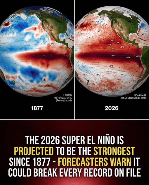
First, let’s review what the heck an El Nino is. So, it is a natural occurring climate cycle known as the El Nino or Southern Oscillation. During these events, the sea surface temperatures in the central and eastern equatorial Pacific Ocean area become warmer than average. The latest report from the Climate Prediction Center reports that right now, ENSO-Neutral conditions are continuing with near average sea surface temperatures in that area. They also report that there are indicators that favor an increase in those temperatures with some of the indicators suggesting a significate above average temperature change.
The Center’s confidence that we will shift to El Nino conditions has increased, and they expect to see the shift from the Neutral to El Nino conditions sometime next month, and these conditions will likely persist through the 2026-2027 winter months.
So, what about the Super El Nino conditions? The Climate Prediction Center says that while the confidence has increased that we will shift to El Nino conditions, there is still considerable uncertainty on just how strong this event will be. They report that there are no strength categorizations exceeding a 37% chance.
And what if it does occur? They have found that stronger El Nino events do not ensure you will see strong impacts, but they do increase the probabilities, making certain impacts more likely. What are these impacts you ask? If we were to see the Super El Nino, it would increase the chances of seeing a more active southern subtropical jet that could bring heavy rainfall to the south, into California, through the Gulf States into Florida. For us it would mean unusually warm and dry winter conditions. It also usually suppresses Atlantic Hurricane activity, though the Eastern Pacific could become more active. As for the rest of the world, places like the Amazon, Indonesia, Australia and parts of Africa could see their normal monsoonal pattern disrupted.
Finally, to summarize, yes, it is likely that an El Nino pattern will materialize in the next month or so and this pattern will continue through our winter months of 2026-2027. Exactly how strong is still uncertain. Admittedly, some of the models suggest the temperatures could be classified as an extreme anomaly, possibly making it one of the most powerful cycles in modern history.
My take on this is – it is still too early to guarantee a “super” event. For a true Super El Niño to take place, something called a continuous atmospheric feedback loop must form. This requires sustained, reversed wind patterns (westerly wind bursts) to keep pushing warm water eastward. As of mid-May, these required wind patterns have not completely synchronized with the ocean warming. Also know that Ocean models frequently overestimate intensity during the spring, meaning the system could still peak as a standard El Niño or return to neutral conditions.