Menu
  • Home
  • Breaking News
  • Feature
    • Arts
    • Astrology
    • Business
    • Community
    • Employment
    • Event Stories
    • From the Pioneer
    • Government
    • Letters to the Editor
    • Non Profit News
    • Obituary
    • Public Safety
    • Podcast Interview Articles
    • Pioneer Pulse Podcast: Politics, Palette, and Planet – the Playlist
  • Weather
  • Guest Column
    • Perspectives
    • Don Backman Photos
    • Ardent Gourmet
    • Kitchen Maven
    • I’ve been thinking
    • Jim Heffernan
    • The Littoral Life
    • Neal Lemery
    • View From Here
    • Virginia Carrell Prowell
    • Words of Wisdom
  • Things to do
    • Calendar
    • Tillamook County Parks
    • Tillamook County Hikes
    • Whale Watching
    • Tillamook County Library
    • SOS Community Calendar
  • About
    • Contribute
    • Advertise
    • Subscribe
    • Opt-out preferences
  • Post Submission Test
  • Search...
Menu

Gordon’s Update Thursday, June 10, 2021, 9:10am

Posted on June 10, 2021 by Editor

By Gordon McCraw, Tillamook County Emergency Manager
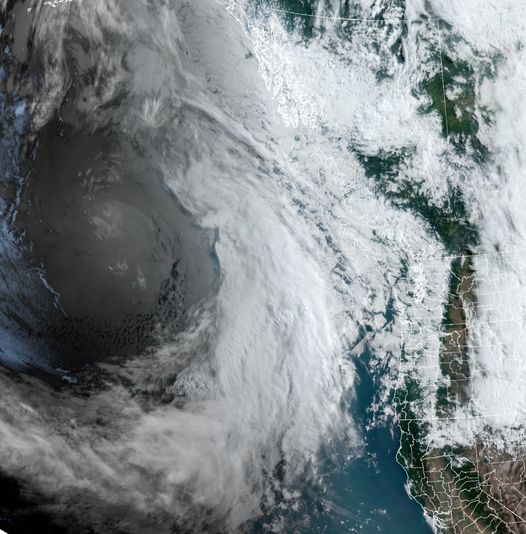
Weather
We have what is referred to as a dirty ridge today. There is a slight chance of some light, brief showers today with the winds becoming southwesterly 5-10, the afternoon high near 62. We do have an approaching decent, summer front coming that will push in the rain overnight tonight, after midnight.
So, tomorrow (Friday) will be rainy and becoming breezy as the front approaches the coast, winds becoming easterly to start, 8-12 gusting to 25, then becoming southerly 5-10 gusting to 20 with the front itself tomorrow night, highs near 60, lows near 51.
The front will likely slow or stall which will allow disturbances to ride in the southwesterly flow so look for periods of rain Saturday, Sunday on into Monday. If this were the winter, this atmospheric river event would be giving us some heavy rain and flooding concern. This being more like summer, we can expect maybe ½” of rain though if just the right conditions develop, the Coast Range could see over an inch, maybe even 2” of rain from the weekend thru Monday.
The longer range models show the front being kicked out Monday night into Tuesday so we could expect some post-frontal scattered showers Tuesday follow by a high pressure ridge bringing sunny skies Wednesday with highs up near 70, lows near 49.

2021 Developing Drought Conditions

Yes, even though the next few days will be bringing us some welcomed rain, it will still not keep us from the expected drought conditions forecasted for this summer. With the below-average rainy spring and the rapid snow runoff, there is a good chance that this will be the worse conditions seen for quite some time and in fact, for much of the area, the March-April-May timeframe is the driest on record.
The lack of rain has resulted in some very low streamflow’s with flows comparable to the 2015 low levels. The low levels can cause warmer than normal waters that is not good for some of the aquatic species. It is reported that the forest conditions in some areas are already similar to what is normally seen in July or August. The impacts from this will obviously send our fire dangers to extreme much sooner than usual. Below is a good example of where we stand in the last report. The upcoming rain will help by delaying the conditions some, but it won’t last.

…NW Oregon Coastal…

River Apr-Sep Fcst (thousands acre/ft.) % of normal Ranking

Nehalem R near Foss 123 37 Lowest

Siletz R at Siletz 80 40 Lowest

Siuslaw R near Mapleton 99 36 Lowest

Trask R near Tillamook 62 43 Lowest

Wilson R near Tillamook 66 43 Lowest

Unsubscribe

Featured Video

Slide Contribute SUBSCRIBE

Tillamook Weather

Tides

Tillamook County Pioneer Podcast Series

Tillamook Church Search

Cloverdale Baptist Church
Nestucca Valley Presbyterian
Tillamook Ecumenical Service

Archives

  • Home
  • EULA Privacy Policy
  • Contact
  • Opt-out preferences
  • Search...
Share on facebook
Facebook
Share on pinterest
Pinterest
Share on twitter
Twitter
Share on linkedin
Linkedin
Catherine

Recent Posts

  • Tillamook Air Museum to Acquire Historic U.S. Coast Guard HU-25 Guardian

    May 24, 2025
  • Celebrate May at Camp Magruder with Two Special Events: Camp Magruder’s 80th Anniversary Celebration May 24th & Community Open House May 31st

    May 24, 2025
  • RESIDENTS STAND TOGETHER AGAINST CIRCUS CRUELTY IN TILLAMOOK, PROTEST OF JORDAN CIRCUS AT TILLAMOOK COUNTY FAIRGROUNDS TUESDAY MAY 27th

    May 24, 2025
©2025 | Theme by SuperbThemes

Manage Cookie Consent
To provide the best experiences, we use technologies like cookies to store and/or access device information. Consenting to these technologies will allow us to process data such as browsing behavior or unique IDs on this site. Not consenting or withdrawing consent, may adversely affect certain features and functions.
Functional Always active
The technical storage or access is strictly necessary for the legitimate purpose of enabling the use of a specific service explicitly requested by the subscriber or user, or for the sole purpose of carrying out the transmission of a communication over an electronic communications network.
Preferences
The technical storage or access is necessary for the legitimate purpose of storing preferences that are not requested by the subscriber or user.
Statistics
The technical storage or access that is used exclusively for statistical purposes. The technical storage or access that is used exclusively for anonymous statistical purposes. Without a subpoena, voluntary compliance on the part of your Internet Service Provider, or additional records from a third party, information stored or retrieved for this purpose alone cannot usually be used to identify you.
Marketing
The technical storage or access is required to create user profiles to send advertising, or to track the user on a website or across several websites for similar marketing purposes.
Manage options Manage services Manage {vendor_count} vendors Read more about these purposes
View preferences
{title} {title} {title}