By Gordon McCraw, Meteorologist for the Tillamook County Pioneer
So, the previous low pressure area continues to move off into British Columbia but we still have some unstable air rotating in giving us some scattered showers. So far, in the last 24 hours, Tillamook has seen from around 2/3” of rain up to 1 ¼” of rain in the area with the top of Mt. Hebo getting almost 2 ½”. Again, with the mainly southerly winds, the temperatures continue on the moderate side.
The activity should become less frequent this afternoon and evening as the low pressure area continues further into Canada, but then back comes more rain after midnight ahead of yet another warm front moving towards the area, with the winds tonight becoming southeasterly 8-12, the overnight low near 45.
Tomorrow looks cloudy, rainy, and breezy with southeasterly winds 10-15 gusting to 20, the high still up near 54, the rain continues tomorrow night, the winds becoming southerly 15-20 gusting to near 30, the lows only dropping to near 48. The total rainfall for the 24 hours period Friday between a half an inch to around one and one-half inches, with the higher amounts in the Coast Range. This will cause increased flow rates in the rivers, but they all are expected to remain well below Action Stage, so river flooding concerns remain low.
It looks like Saturday the front pushes through and we transition back to showers, the winds southerly 5-10 gusting to 18, with the afternoon high now up near 58. The associated cold front brings more rain Saturday night, still on the breezy side, the low temperatures only down to near 53.
Sunday is when things start to get interesting, and difficult to forecast to a higher level of certainty. Sunday should start out with showers, still breezy, the high pushing up near 63 in the afternoon when high pressure briefly builds in and decreases the showers activity, only a slight chance of showers Sunday night, the low drops to near 53 again.
Sunday night is also when we see an atmospheric river setting up and taking aim at the Pacific northwest. What the models can’t agree on right now is where that hose will be pointed. It looks like there will be a ridge of high pressure to the east over the Rockies with the trough of low pressure associated with the atmospheric river off to the west. Right now, it is looking like Monday into Tuesday the area of greater rainfall will be to the north. At issue is some models build the ridge in stronger and further west which would push the atmosphere river further north and keep us relatively dry. Others push the atmospheric river further south, increasing the rain for our area. In either case, it looks like we will see increasing rain later Tuesday into Wednesday in our area.
So, just to break all this down, Monday and Tuesday look rainy, with a chance it could be heavy rain at times, and breezy also with the highs temperatures still in the low 60s and low temperatures in the low 50s. Currently Wednesday and Thursday also look rainy, with a slightly better chance of seeing periods of heavy rain, with highs around 60, lows around 50.
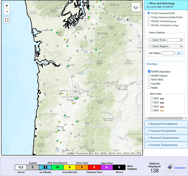
A quick look at the river forecasts shows them going up and down with the rain the rest of the week, weekend, and on into next week. As is always the case, these are subject to change with future model runs. Again, just something to keep an eye on. The current river forecasts for northwestern Oregon shows the current rivers of concern are all over in the valley from Washington southward to near Eugene, likely the result of the expected warmer temperatures adding the snow melt to those river basins that will also be seeing increased rainfall periods.
Here is the River and Hydrology Section 10-Day Forecast: