Menu
  • Home
  • Breaking News
  • Feature
    • Arts
    • Astrology
    • Business
    • Community
    • Employment
    • Event Stories
    • From the Pioneer
    • Government
    • Letters to the Editor
    • Non Profit News
    • Obituary
    • Public Safety
    • Podcast Interview Articles
    • Pioneer Pulse Podcast: Politics, Palette, and Planet – the Playlist
  • Weather
  • Guest Column
    • Perspectives
    • Don Backman Photos
    • Ardent Gourmet
    • Kitchen Maven
    • I’ve been thinking
    • Jim Heffernan
    • The Littoral Life
    • Neal Lemery
    • View From Here
    • Virginia Carrell Prowell
    • Words of Wisdom
  • Things to do
    • Calendar
    • Tillamook County Parks
    • Tillamook County Hikes
    • Whale Watching
    • Tillamook County Library
    • SOS Community Calendar
  • About
    • Contribute
    • Advertise
    • Subscribe
    • Opt-out preferences
  • Post Submission Test
  • Search...
Menu

GORDON’S UPDATE: Weather 11/29/23 – Last dry day for awhile … keeping an eye on the rivers

Posted on November 29, 2023 by Editor
www.tillamookcountypioneer.net

By Gordon McCraw, Meteorologist for the Tillamook County Pioneer
The pattern is shifting today from the dry, sunny, but cold high pressure ridge, to a series of fronts that will bring us rain and winds, and even a chance of thunderstorms, for the rest of the week, weekend, and into the start of next week.

The easterly flow we have seen shifted, becoming more westerly, then southerly, as the high pressure ridge weakens and gets pushed eastward by a trough and front rotating towards the coast tonight. Look for increasing clouds with an increasing chance of rain later tonight with the low temperature dropping to near 37.

The rain is likely by the early morning hours tomorrow as the front moves in, winds southeasterly 5-10, then we transition to post-frontal showers with possible thunderstorms tomorrow evening, the winds becoming westerly 5-10, highs near 50. We see more showers and a slight chance of thunderstorms tomorrow night until the next front pushes in more rain starting a little before midnight, winds becoming southerly 4-8, lows near 39. Total rain from this first event between ½ to 1”.

Friday starts out rainy, then again transitions to showers with possible thunderstorms by the afternoon, the winds increasing from the west 15-20 gusting to 35, highs near 52, more showers and possible thunderstorms Friday night, still windy, lows near 54. Look for another ½ to 1” of rain Friday.

The routine duplicates again Saturday, starting out with showers with a chance of isolated thunderstorms but transitioning to rain by the afternoon, breezy, highs near 54, cloudy and rainy Saturday night, lows near 45.

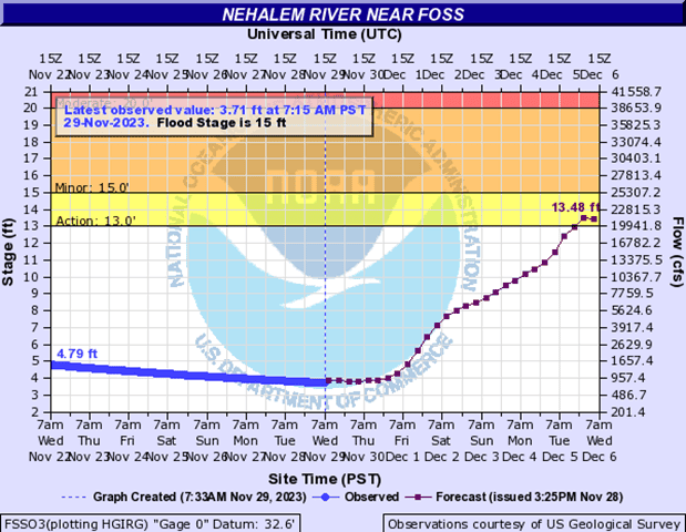
Sunday conditions appear to be setting up favorably for an atmospheric river type event, bring warmer rain into the Pacific northwest, possibly bringing heavy rain into the area, especially in the Coast Range with a possible 3 to 4” of rain possible in the 24 hour period starting Saturday night through Sunday night. This has the potential to push our rivers, especially the Nehalem River, up to bankfull. At this time, it appears that none of the rivers get to Flood Stage. As always, this should be watched closely between now and the weekend for any significant changes to the forecasts. It might be a good idea for residents and businesses to discuss their plans should the forecasts change to show possible flooding. As you can see in the current Nehalem River forecast, cresting is around Tuesday night into Wednesday morning.

Monday we are likely to see another warm front pushing more rain and winds into the area that persist through Tuesday into Wednesday, then it appears the rain eases some Thursday and Friday, highs up near 58, lows near 49.

Listen here to Gordon’s KMUN Weather Forecast:

Featured Video

Slide Contribute SUBSCRIBE

Tillamook Weather

Tides

Tillamook County Pioneer Podcast Series

Tillamook Church Search

Cloverdale Baptist Church
Nestucca Valley Presbyterian
Tillamook Ecumenical Service

Archives

  • Home
  • EULA Privacy Policy
  • Contact
  • Opt-out preferences
  • Search...
Share on facebook
Facebook
Share on pinterest
Pinterest
Share on twitter
Twitter
Share on linkedin
Linkedin
Catherine

Recent Posts

  • ARDENT GOURMET: Stunning Szechuan Garden in Hillsboro

    May 19, 2025
  • South County Candidates Forum: Nestucca Valley School District Candidates say, “Get Out the Vote!”

    May 19, 2025
  • REPRESENTATIVE CYRUS JAVADI TOWN HALL MAY 21ST IN TILLAMOOK AT TBCC

    May 19, 2025
©2025 | Theme by SuperbThemes

Manage Cookie Consent
To provide the best experiences, we use technologies like cookies to store and/or access device information. Consenting to these technologies will allow us to process data such as browsing behavior or unique IDs on this site. Not consenting or withdrawing consent, may adversely affect certain features and functions.
Functional Always active
The technical storage or access is strictly necessary for the legitimate purpose of enabling the use of a specific service explicitly requested by the subscriber or user, or for the sole purpose of carrying out the transmission of a communication over an electronic communications network.
Preferences
The technical storage or access is necessary for the legitimate purpose of storing preferences that are not requested by the subscriber or user.
Statistics
The technical storage or access that is used exclusively for statistical purposes. The technical storage or access that is used exclusively for anonymous statistical purposes. Without a subpoena, voluntary compliance on the part of your Internet Service Provider, or additional records from a third party, information stored or retrieved for this purpose alone cannot usually be used to identify you.
Marketing
The technical storage or access is required to create user profiles to send advertising, or to track the user on a website or across several websites for similar marketing purposes.
Manage options Manage services Manage {vendor_count} vendors Read more about these purposes
View preferences
{title} {title} {title}