Menu
  • Home
  • Feature
    • Breaking News
    • Arts
    • Astrology
    • Business
    • Community
    • Employment
    • Event Stories
    • From the Pioneer
    • Government
    • Letters to the Editor
    • Non Profit News
    • Obituary
    • Public Safety
    • Podcast Interview Articles
    • Pioneer Pulse Podcast: Politics, Palette, and Planet – the Playlist
  • Guest Column
    • Perspectives
    • Don Backman Photos
    • Ardent Gourmet
    • Kitchen Maven
    • I’ve been thinking
    • Jim Heffernan
    • The Littoral Life
    • Neal Lemery
    • View From Here
    • Virginia Carrell Prowell
    • Words of Wisdom
  • Weather
  • Post Submission
  • Things to do
    • Calendar
    • Tillamook County Parks
    • Tillamook County Hikes
    • Whale Watching
    • Tillamook County Library
    • SOS Community Calendar
  • About
    • Contribute
    • Advertise
    • Subscribe
    • Opt-out preferences
  • Search...
Menu

GORDON’S UPDATE – UPDATED Noon : Weather 12/26/22 – Hang on to your hats! 2022 goes out with a blow …

Posted on December 26, 2022December 26, 2022 by Editor

Current Warnings/Advisories include High Surf, Coastal Flooding, Beach Hazards, Storm and Wind Warning
By Gordon McCraw, Meteorologist for the Tillamook County Pioneer
Monday, December 26, 2022 – Noon

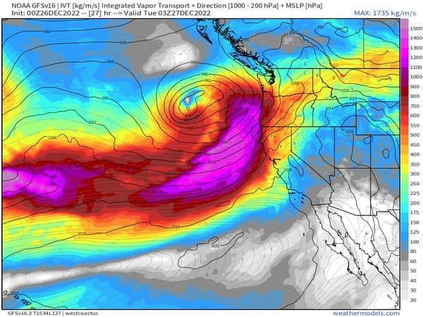
Winter, the gift that keeps on giving. With the ice storm winding down with the only area still having issues being the Gorge, now we get a series of strong Pacific Storms moving in. The first moved across earlier today bringing between 1” to 1 1/2” of rain but with gusty winds leading to some local power outages.

The next in the series of storms is forecasted to intensify as it moves into Washington and will be even stronger than this morning’s system. This next system is expected to bring even stronger winds and rain, heavy at times, along with high seas with possible Coastal Flooding and increased sneaker wave concerns. The coastal area is expected to get another 1-2” of rain while parts of the Coast Range could see 3-4” on top of the inch or more many areas have already seen. Winds inland could gust to 35-45 with gust to 55-65 possible at the beaches. The coastal waters are looking at a Storm Warning starting tonight that could bring 25’ breakers and add to this that we are coming out of a King Tide period where high tides are still elevated enough that, when you add increased river levels, tide anomalies, and somewhat higher tide, Coastal Overflow Flooding is possible. On the positive side though, tonight’s low temperatures are only forecasted to be around 46 degrees. Oh, and did I mention the chance of thunderstorms later tonight once the front passes through?

The rain and rainshowers continue tomorrow, still with the possibility of thunderstorms, and the southwesterly winds increase to 25-35 gusting to 40-50 inland, possibly 60-70 at the beaches as the system’s associated low pressure area pushes into Washington. The activity eases some tomorrow night, still with showers, the southwesterly winds 15-20 gusting to 35. Highs tomorrow drop to around 44 during the day and down to 40 at night. The area can expect another ½ to 1” of rain tomorrow but with the westerly flow, the Coast Ranges could see 1-3” of rain. This will be something we need to watch, for effects on the coastal river levels. The Nehalem and Wilson are now expected to reach bankfull, subject to change between now and then!

The activity eases Wednesday with scattered showers and southerly winds 5-10, highs near 46, lows near 39, then the chance of rain returns later Wednesday night with the next system bringing rain thru Thursday into Friday, but then things start to wind down for the weekend with the rain decreasing Saturday then Sunday just Mostly Cloudy and 46 to usher in the New Year!

Slide Slide Slide Slide Slide Slide Slide Slide Subscribe Contribute

Ads

Featured Video

Tillamook Weather

Tides

Tillamook County Pioneer Podcast Series

Tillamook Church Search

Cloverdale Baptist Church
Nestucca Valley Presbyterian
Tillamook Ecumenical Service

Archives

  • Home
  • EULA Privacy Policy
  • Contact
  • Opt-out preferences
  • Search...
Share on facebook
Facebook
Share on pinterest
Pinterest
Share on twitter
Twitter
Share on linkedin
Linkedin
Catherine

Recent Posts

  • TILLAMOOK COUNTY CREAMERY ASSOCIATION WORK-STUDY PROGRAM CREATES OPPORTUNITIES

    June 30, 2025
  • TILLAMOOK POLICE DEPARTMENT: Damascus Man Sentenced to 28 Years for Attempted Murder of Law Enforcement Officers in Tillamook County

    June 30, 2025
  • BOOK REVIEW: Abundance by Ezra Klein & Derek Thompson

    June 29, 2025
©2025 | Theme by SuperbThemes

Manage Cookie Consent
To provide the best experiences, we use technologies like cookies to store and/or access device information. Consenting to these technologies will allow us to process data such as browsing behavior or unique IDs on this site. Not consenting or withdrawing consent, may adversely affect certain features and functions.
Functional Always active
The technical storage or access is strictly necessary for the legitimate purpose of enabling the use of a specific service explicitly requested by the subscriber or user, or for the sole purpose of carrying out the transmission of a communication over an electronic communications network.
Preferences
The technical storage or access is necessary for the legitimate purpose of storing preferences that are not requested by the subscriber or user.
Statistics
The technical storage or access that is used exclusively for statistical purposes. The technical storage or access that is used exclusively for anonymous statistical purposes. Without a subpoena, voluntary compliance on the part of your Internet Service Provider, or additional records from a third party, information stored or retrieved for this purpose alone cannot usually be used to identify you.
Marketing
The technical storage or access is required to create user profiles to send advertising, or to track the user on a website or across several websites for similar marketing purposes.
Manage options Manage services Manage {vendor_count} vendors Read more about these purposes
View preferences
{title} {title} {title}