Menu
  • Home
  • Feature
    • Breaking News
    • Arts
    • Astrology
    • Business
    • Community
    • Employment
    • Event Stories
    • From the Pioneer
    • Government
    • Letters to the Editor
    • Non Profit News
    • Obituary
    • Public Safety
    • Podcast Interview Articles
    • Pioneer Pulse Podcast: Politics, Palette, and Planet – the Playlist
  • Guest Column
    • Perspectives
    • Don Backman Photos
    • Ardent Gourmet
    • Kitchen Maven
    • I’ve been thinking
    • Jim Heffernan
    • The Littoral Life
    • Neal Lemery
    • View From Here
    • Virginia Carrell Prowell
    • Words of Wisdom
  • Weather
  • Post Submission
  • Things to do
    • Calendar
    • Tillamook County Parks
    • Tillamook County Hikes
    • Whale Watching
    • Tillamook County Library
    • SOS Community Calendar
  • About
    • Contribute
    • Advertise
    • Subscribe
    • Opt-out preferences
  • Search...
Menu

GORDON’S UPDATE: Weather – 12/9/22

Posted on December 9, 2022 by Editor

By Gordon McCraw, Meteorologist for the Tillamook County Pioneer
Friday, December 9, 2022
Weather

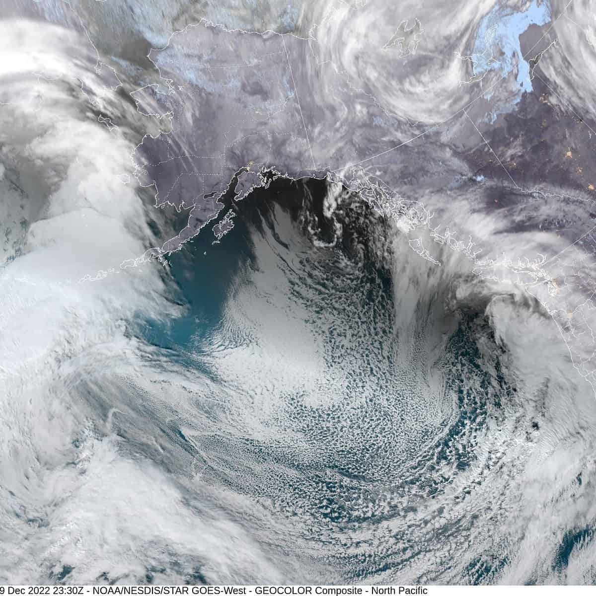
The weather map has become active once again with a Gale Warning out for the coastal waters to our west, kicking the seas up to 17-22’ tonight. I would be concerned about sneaker waves along the shore as a result. To our east there are Winter Storm Warnings for the Cascades and Winter Storm Advisories in other parts of the Cascades. As for us, an upper level low pressure area will continue to move southeastward from the Gulf of Alaska this evening, pushing another front, with its associated rain, thru the area along with some breezy southerly winds 14-18 gusting to 25. With the southerly flow the temperatures will actually rise some tonight, to around 49, and it pushes the snow level up close to 3000’.

The rain continues tomorrow morning then the front itself pushes thru by around noon and we transition over to scattered showers with possible thunderstorms, the winds still southerly 5-10, highs still around 49. The thunderstorm threat ends by tomorrow night though we will continue to see the showers persist though becoming more scattered in nature by midnight. We see light winds tomorrow night, the snow level down to near 2500’ with low temperatures down near 36.

The previously mentioned low pressure area continued to move south Saturday and will continue its southward movement Sunday, but far enough offshore to not impact our area so look for mostly cloudy skies Sunday, only a 40% chance of showers with the winds diminishing, the snow level dropping to around 2300’, with the afternoon highs around 47. With the low well south of the area, Sunday night we expect mostly cloudy and dry conditions, the low dropping to near 34.

We are between systems Monday with partly sunny skies, the high near 46 and mostly cloudy skies Monday night, lows near 33.

Tuesday the models start conflicting but it looks like another system approaches so mostly cloudy skies with a slight chance of showers in the forecast, the snow level around 2000’, highs near 47, still a slight chance of showers Tuesday night as the snow level drops to near 500’ with the lows maybe falling to near 30 so there is a slight chance of low level snow in the early morning hours Wednesday if the moisture is still there.

Wednesday looks mostly sunny with that slight chance of showers still, the snow level lifting to around 1400’ so some snow is still possible in the passes. The high near 45 then we dry out again Wednesday night when the low drops to near 29 under partly cloudy skies.

Good news, Thursday looks mostly sunny, but it will still be on the cooler side with the high around 44.

The usual disclaimer, with the conflicting models, next week’s weather could change some, for better or worse!

Slide Slide Slide Slide Slide Slide Slide Slide Subscribe Contribute

Ads

Featured Video

Tillamook Weather

Tides

Tillamook County Pioneer Podcast Series

Tillamook Church Search

Cloverdale Baptist Church
Nestucca Valley Presbyterian
Tillamook Ecumenical Service

Archives

  • Home
  • EULA Privacy Policy
  • Contact
  • Opt-out preferences
  • Search...
Share on facebook
Facebook
Share on pinterest
Pinterest
Share on twitter
Twitter
Share on linkedin
Linkedin
Catherine

Recent Posts

  • TILLAMOOK COUNTY CREAMERY ASSOCIATION WORK-STUDY PROGRAM CREATES OPPORTUNITIES

    June 30, 2025
  • TILLAMOOK POLICE DEPARTMENT: Damascus Man Sentenced to 28 Years for Attempted Murder of Law Enforcement Officers in Tillamook County

    June 30, 2025
  • BOOK REVIEW: Abundance by Ezra Klein & Derek Thompson

    June 29, 2025
©2025 | Theme by SuperbThemes

Manage Cookie Consent
To provide the best experiences, we use technologies like cookies to store and/or access device information. Consenting to these technologies will allow us to process data such as browsing behavior or unique IDs on this site. Not consenting or withdrawing consent, may adversely affect certain features and functions.
Functional Always active
The technical storage or access is strictly necessary for the legitimate purpose of enabling the use of a specific service explicitly requested by the subscriber or user, or for the sole purpose of carrying out the transmission of a communication over an electronic communications network.
Preferences
The technical storage or access is necessary for the legitimate purpose of storing preferences that are not requested by the subscriber or user.
Statistics
The technical storage or access that is used exclusively for statistical purposes. The technical storage or access that is used exclusively for anonymous statistical purposes. Without a subpoena, voluntary compliance on the part of your Internet Service Provider, or additional records from a third party, information stored or retrieved for this purpose alone cannot usually be used to identify you.
Marketing
The technical storage or access is required to create user profiles to send advertising, or to track the user on a website or across several websites for similar marketing purposes.
Manage options Manage services Manage {vendor_count} vendors Read more about these purposes
View preferences
{title} {title} {title}