EDITOR’S NOTE: Over the next few daysand into next, it’s likely you will see a varying forecasts as there are various models that meteorologists look at. That’s why we hire the experts. Gordon looks at LOTS of sources, models, charts and stuff, as well as relying on his decades of experience living here in the Pacific Northwest. The comments he sends along with these forecasts are often the best summary: “WOW…quite the forecast (if he says so himself) as the word “SNOW” keeps reappearing… The bottom line, we have snow and ice concerns continuing for another week!”
By Gordon McCraw, Meteorologist for the Tillamook County Pioneer
Friday, February 24, 2023
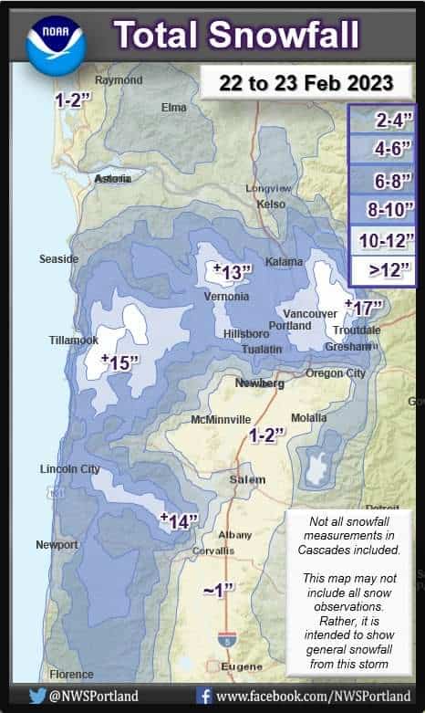
Well, let’s start with all the snowfall totals from the National Weather Service.
As of yesterday (2/23/23) morning, a sampling of the totals:
North Oregon Coast
Tillamook 14.6”
Pleasant Valley 8.0”
Netarts & Neskowin 7.0”
Rockaway 6.0”
Astoria 1.5”
Cannon Beach 1.2”
NW Coast Range
Vernonia 10.0”
ODOT this morning reports 25” roadside
Portland Metro Area
Gresham 12.0”
Hillsboro 10.0”
Forest Grove 10.0”
Swan Island 8.5”
Happy Valley 7.0”
Scappoose 7.0”
Beaverton 6.5”
Central Willamette Valley
Silver Falls 11.5”
Dallas 4.0”
Salem 3.0”
South Willamette Valley
Philomath 5.0”
Lebanon (my house) 1.5”
Now, as far as this early morning low temperatures, for the coast, you were in the mid 20s but with the breezy winds, the windchill was in the low to mid teen. Up at the summit of Hwy 6 it was 13 degrees, but Hwy 26 reported the temperature at 1, yes – one!
So the forecast is for a sunny day today, winds northeasterly 10-15 gusting to 25-30, the high near 44, with mostly clear skies tonight and northerly winds 4-8, the low drops to near 20, winchills in the low teens.
Tomorrow we see some clouds moving in again ahead of a trough of low pressure that will bring rain back into the area tomorrow evening ahead of a fast moving front. The snow level will be around 1000’ but with heavier rain, a rain/snow mix is possible lower so we can expect more snow across Hwy 6 and maybe the higher elevation of Hwy 101 once again. The winds will be shifting tomorrow night to southerly 10-20 gusting to 25 so the snow level will be climbing to near 2000’ around midnight. High temperatures tomorrow up near 44, tomorrow night’s lows down near 32 so snow amounts and exact levels is dependent on how soon the temperature drops tomorrow night before the south winds take effect. The models are showing some lowland snow possible, with higher amounts in the passes obviously.
With more rain Sunday thanks to a low pressure area impacting the area, there is another chance of low snow in the morning hours, still breezy, afternoon highs near 45, the snow level climbing to 1500’ in the afternoon but drops back down to around 1000’ before the sun goes down and down to 500’ that night with the lows down around 30, lower snow is once again possible in the early morning hours.
So, there is that rain or snow or a mix Monday morning then all rain by the afternoon, the high near 44, rainy still that night, the snow level lowering with the temperatures again that night, the lows back down near 30 which spells low snow again.
Tuesday looks to repeat the pattern with highs near 44, lows Tuesday night could drop into the upper 20s which, with the continued rain spells, an even better chance of low snow. Wednesday still a chance of rain and/or snow, highs near 46, lows near 33.
I can’t say it better than the National Weather Service said it, the exact details are uncertain and the forecasts will change some over time and future models, especially in the timing and exact positions of the features and systems. There is a high confidence of the colder than normal temperatures for the rest of February and there is a good chance this will continue into the first few days of March. It looks like areas with more than a couple of inches of snow on the ground could remain snow-covered all the way thru next week. Add to the problems the freeze-thaw cycle each day. Even if you don’t get additional snow, what melts during the day returns as ice that night. The bottom line, STAY TUNED, winter continues!