Menu
  • Home
  • Feature
    • Breaking News
    • Arts
    • Astrology
    • Business
    • Community
    • Employment
    • Event Stories
    • From the Pioneer
    • Government
    • Letters to the Editor
    • Non Profit News
    • Obituary
    • Public Safety
    • Podcast Interview Articles
    • Pioneer Pulse Podcast: Politics, Palette, and Planet – the Playlist
  • Guest Column
    • Perspectives
    • Don Backman Photos
    • Ardent Gourmet
    • Kitchen Maven
    • I’ve been thinking
    • Jim Heffernan
    • The Littoral Life
    • Neal Lemery
    • View From Here
    • Virginia Carrell Prowell
    • Words of Wisdom
  • Weather
  • Post Submission
  • Things to do
    • Calendar
    • Tillamook County Parks
    • Tillamook County Hikes
    • Whale Watching
    • Tillamook County Library
    • SOS Community Calendar
  • About
    • Contribute
    • Advertise
    • Subscribe
    • Opt-out preferences
  • Search...
Menu

GORDON’S UPDATE: Weather 4/13/23 – Winter, that party guest that hasn’t gotten the hint…it’s time to leave!

Posted on April 13, 2023 by Editor

By Gordon McCraw, Meteorologist for the Tillamook County Pioneer
Thursday, April 13, 2023

We had another chilly start this morning with the low morning temperature dropping to 32 again. This afternoon we had another weak disturbance giving us a chance of some showers and tonight we still have a slight chance of some showers with calm winds, the lows tonight down to near 38 and the snow level is around 2400’.

Tomorrow a weak ridge builds into the area, giving us partly sunny skies and putting an end to any remaining widely scattered showers. Winds becoming westerly 4-8 in the afternoon, highs near 53. Look for mostly cloudy skies tomorrow night as the ridge starts moving to the east as a trough of low pressure develops to the west. With calm winds tomorrow night, the lows drop to near 38 again.

Saturday it looks like we have an increasing chance of rain along the coast, starting in the afternoon with that trough moving closer, though several of the models try to keep us on the dryer side until later Saturday night when rain is likely. We can expect southerly winds 5-10 Saturday with highs near 52, lows near 43. The bottom line is the rain moves in Saturday, we just don’t have a good handle on exactly what time.

Sunday sees a front moving in bringing periods of heavy rain with winds becoming southwesterly 15-20 gusting to 30 in the afternoon and evening. The good news is this system will not linger so hydrological concerns remain low. The other good news is the snow level will remain above 2000’. Highs on Sunday near 52, lows near 38.

It looks like we will stay on the cool side with scattered rain or showers the first half of next week with an upper level trough of low pressure over or near the area. So, we can expect mostly cloudy skies with rain or showers, along with occasionally breezy conditions starting Monday and persisting thru at least Wednesday with highs near 50, lows near 37. The snow level could drop close to the summit level in the early morning hours Tuesday, otherwise it lingers around 2100’.

And I hate to say it, but…the long range models suggest we actually stay wet through the end of next week with cooler than average temperatures.

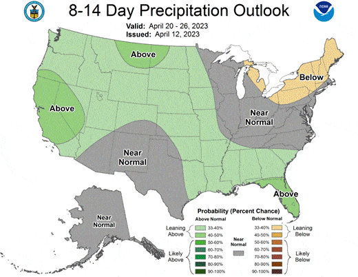
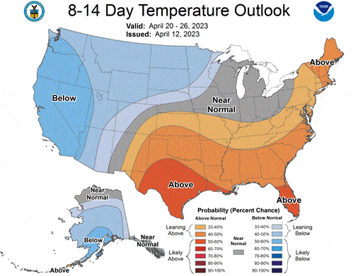
Here is what the Climate Prediction Center’s Latest 8-14 Day Long Range Climatological Forecast’s…where is Spring?


Slide Slide Slide Slide Slide Slide Slide Slide Subscribe Contribute

Ads

Featured Video

Tillamook Weather

Tides

Tillamook County Pioneer Podcast Series

Tillamook Church Search

Cloverdale Baptist Church
Nestucca Valley Presbyterian
Tillamook Ecumenical Service

Archives

  • Home
  • EULA Privacy Policy
  • Contact
  • Opt-out preferences
  • Search...
Share on facebook
Facebook
Share on pinterest
Pinterest
Share on twitter
Twitter
Share on linkedin
Linkedin
Catherine

Recent Posts

  • ROCKAWAY BEACH READIES FOR JULY 4TH FESTIVITIES - HONORS VOLUNTEER OF YEAR & PARADE GRAND MARSHAL

    June 30, 2025
  • NEWS UPDATE FROM STATE REPRESENTATIVE DAVID GOMBERG: It's a Session Wrap!

    June 30, 2025
  • GORDON'S WEEKLY WEATHER UPDATE 6/30/25: Back to Normal Summer Weather This Week - Fair, Dry & Mild; Holiday Weekend Weather Looks Good

    June 30, 2025
©2025 | Theme by SuperbThemes

Manage Cookie Consent
To provide the best experiences, we use technologies like cookies to store and/or access device information. Consenting to these technologies will allow us to process data such as browsing behavior or unique IDs on this site. Not consenting or withdrawing consent, may adversely affect certain features and functions.
Functional Always active
The technical storage or access is strictly necessary for the legitimate purpose of enabling the use of a specific service explicitly requested by the subscriber or user, or for the sole purpose of carrying out the transmission of a communication over an electronic communications network.
Preferences
The technical storage or access is necessary for the legitimate purpose of storing preferences that are not requested by the subscriber or user.
Statistics
The technical storage or access that is used exclusively for statistical purposes. The technical storage or access that is used exclusively for anonymous statistical purposes. Without a subpoena, voluntary compliance on the part of your Internet Service Provider, or additional records from a third party, information stored or retrieved for this purpose alone cannot usually be used to identify you.
Marketing
The technical storage or access is required to create user profiles to send advertising, or to track the user on a website or across several websites for similar marketing purposes.
Manage options Manage services Manage {vendor_count} vendors Read more about these purposes
View preferences
{title} {title} {title}