Menu
  • Home
  • Breaking News
  • Feature
    • Arts
    • Astrology
    • Business
    • Community
    • Employment
    • Event Stories
    • From the Pioneer
    • Government
    • Letters to the Editor
    • Non Profit News
    • Obituary
    • Public Safety
    • Podcast Interview Articles
    • Pioneer Pulse Podcast: Politics, Palette, and Planet – the Playlist
  • Weather
  • Guest Column
    • Perspectives
    • Don Backman Photos
    • Ardent Gourmet
    • Kitchen Maven
    • I’ve been thinking
    • Jim Heffernan
    • The Littoral Life
    • Neal Lemery
    • View From Here
    • Virginia Carrell Prowell
    • Words of Wisdom
  • Things to do
    • Calendar
    • Tillamook County Parks
    • Tillamook County Hikes
    • Whale Watching
    • Tillamook County Library
    • SOS Community Calendar
  • About
    • Contribute
    • Advertise
    • Subscribe
    • Opt-out preferences
  • Post Submission Test
  • Search...
Menu

GORDON’S UPDATE: Weather 8/28/23 – Wet Week Ahead

Posted on August 28, 2023 by Editor

By Gordon McCraw, Meterologist for the Tillamook County Pioneer
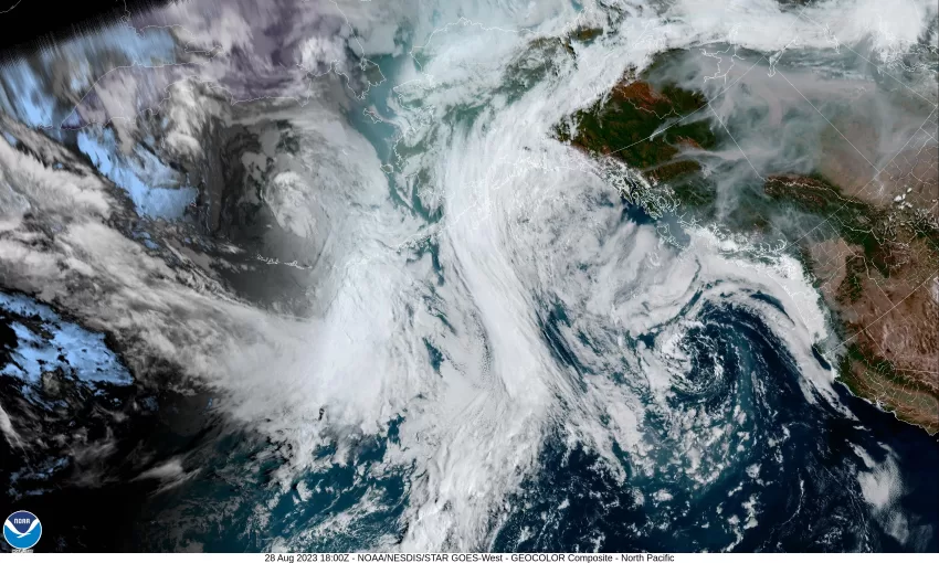
Not much changed this morning, the low pressure area continues to spin in the eastern Pacific, off to our west, but has started to drift eastward. We continue to have marine clouds that pushed in from the west and dropped some moisture in a few lucky areas this morning, and the smoke continues to get pushed up from the south. This all did lead to cooler temperature today.

So, we expect the low pressure area to drift to the northeast tonight and this would bring us a slight chance of showers after around midnight. We can expect the calm winds to return, maybe some patchy fog, the low tonight near 54.

The upper level low is expected to move east tomorrow and bring some scattered showers across the region as it also drags a weak cold front through. The system and the associated more westerly winds will push the smoke layer into eastern Oregon. We can expect cloudy skies with the winds tomorrow becoming southwesterly 5-10 gusting to 20, the high near 67. More showers likely tomorrow night, the winds becoming more southerly 5-10, lows near 57.

Wednesday, we see partly sunny skies with about a 50/50 chance of showers still, winds becoming southwesterly 5-10, the high near 67, still a shower chance that night, light winds, lows near 54.

It looks like the previous low pressure area will be well east of the state by Thursday while another trough of low pressure approaches the coast and brings a good chance of showers again as it continues to develop into another low pressure area up over coastal Washington. This means showers are likely for Thursday with highs near 65, lows near 52.

Friday the low pressure area continues to drop south along the coast giving us continued partly sunny skies with a chance of showers during the day but they become more widely scattered Friday night as the low drops south of our area, highs near 69, lows near 53.

As for the weekend, some of the models say warmer and drier, while the others say we will continue to see scattered showers in the region. This leads to a forecast with a slight chance of scattered showers, partly to mostly sunny daytime skies with highs near 70, and mostly cloudy nights with the slight chance of scattered showers, lows near 52.

Featured Video

Slide Contribute SUBSCRIBE

Tillamook Weather

Tides

Tillamook County Pioneer Podcast Series

Tillamook Church Search

Cloverdale Baptist Church
Nestucca Valley Presbyterian
Tillamook Ecumenical Service

Archives

  • Home
  • EULA Privacy Policy
  • Contact
  • Opt-out preferences
  • Search...
Share on facebook
Facebook
Share on pinterest
Pinterest
Share on twitter
Twitter
Share on linkedin
Linkedin
Catherine

Recent Posts

  • BRAVER ANGELS: Oregon Rural Urban Project Town Hall at Tillamook Library May 17th from 1 to 3pm

    May 11, 2025
  • Manzanita Citizen of the Year Nominations Open

    May 11, 2025
  • Support for Christy Kay for NCRD Board

    May 11, 2025
©2025 | Theme by SuperbThemes

Manage Cookie Consent
To provide the best experiences, we use technologies like cookies to store and/or access device information. Consenting to these technologies will allow us to process data such as browsing behavior or unique IDs on this site. Not consenting or withdrawing consent, may adversely affect certain features and functions.
Functional Always active
The technical storage or access is strictly necessary for the legitimate purpose of enabling the use of a specific service explicitly requested by the subscriber or user, or for the sole purpose of carrying out the transmission of a communication over an electronic communications network.
Preferences
The technical storage or access is necessary for the legitimate purpose of storing preferences that are not requested by the subscriber or user.
Statistics
The technical storage or access that is used exclusively for statistical purposes. The technical storage or access that is used exclusively for anonymous statistical purposes. Without a subpoena, voluntary compliance on the part of your Internet Service Provider, or additional records from a third party, information stored or retrieved for this purpose alone cannot usually be used to identify you.
Marketing
The technical storage or access is required to create user profiles to send advertising, or to track the user on a website or across several websites for similar marketing purposes.
Manage options Manage services Manage {vendor_count} vendors Read more about these purposes
View preferences
{title} {title} {title}