
By Gordon McCraw, Meteorologist for the Tillamook County Pioneer
Boy, a chilly start this morning under the clear morning skies, I saw a low temperature of 39 at the airport reported around 7:30AM. With the mostly sunny day, the afternoon temperatures climb into the mid 60s in most places. Tonight, we will see another weak front bring in another chance of some light rainshowers as it moves into and across the area, bringing a trace to a couple hundreds of an inch of precipitation. With light winds tonight, the low down around 46.
I should mention that there is still a concern at the beaches about the possibility of sneaker waves today. As the National Weather Service points out, waves can run up significantly farther on a beach than normal, including over rocks and jetties. These sneaker waves can suddenly knock people off their feet and quickly pull them into the cold ocean waters, resulting in serious injury or death. Keep children and pets away from the surf zone. Keep off jetties, rocks and logs near the surf zone. If you see someone swept into the sea do not swim in after them. Call 911 and keep an eye on them until help arrives. Though the NWS Beach Hazards Statement runs out later this afternoon, we, that live at the beach, know that they can actually occur at any time!
Now, back to the forecast, we expect mostly cloudy skies to start tomorrow, still with a chance of scattered light showers that will become more widely scattered then diminish later in the afternoon with mostly sunny skies, winds becoming northwesterly 8-12, the high near 64. High pressure is building in tomorrow night bringing mostly clear skies, lows down near 44.
Thursday the ridge of high pressure dominates our weather while a low pressure area moves southward through central Oregon, but we still see the mostly sunny skies locally, the winds becoming northerly 5-10, highs near 68, then mostly clear skies Thursday night, calm winds, lows near 47.
Starting Friday, the forecast gets a little harder as the models are not all agreeing. It looks like a trough and front push into, then through the area. We still see a sunny day Friday, then some clouds and a chance of rain moves in by Friday night, the high near 69, lows near 50.
As for the weekend, the models are mixed on the timing and strength of this next system, but it appears we are looking at mostly cloudy skies on Saturday and Sunday with a chance of rain, highs around the mid 60s, lows near 49.
Monday looks partly sunny, maybe some scattered showers still, the high near 67.
Ring of Fire coming to an area near you Annular Eclipse Oct. 14th!
I posted this on my Facebook Page but thought for safety reasons, I would include it here too.
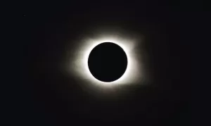 So, Johnny Cash sang the song “Ring of Fire”, but coming soon, Mother Nature will be singing it across Oregon. On October 14th at around 8:00AM, a solar eclipse will be moving from northwest to the southeast. This eclipse will be a little different than the one we had a few years back, this one will not be a Total Eclipse, but instead be an Annular Eclipse, also know as a “Ring of Fire” eclipse. The eclipse will move across Oregon and part of California, through Utah into Colorado and New Mexico before crossing Texas on into the Gulf of Mexico. In Oregon, it will be visible over Albany, Eugene, Springfield, Crater Lake, Roseburg, Medford and even Lakeview then into California.
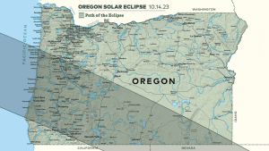
This eclipse is called Annular because not all of the sun will be obscured by the moon. In this event you will see a bright ring from the sun around the edge of the moon. This is because the moon is at its furthest distance from earth when it passes in front of the sun, which is why it does not totally obscure the sun and leaves the visible ring. The eclipse will reach its peak at around 9:18AM over the Eugene area and will produce near darkness in its path. Daylight should return around 10:39AM.
Remember though, it is NOT safe to view any point of the event without wearing CERTIFIED eye protection. You need to have on this eye protection at every stage of the eclipse, including the “Ring of Fire” period! Staring at the sun for ANY amount of time is never safe and could actually cause permanent eye damage including permanent blindness!
If you plan on watching this event, now is the time to order your special viewing glasses!