Menu
  • Home
  • Breaking News
  • Feature
    • Arts
    • Astrology
    • Business
    • Community
    • Employment
    • Event Stories
    • From the Pioneer
    • Government
    • Letters to the Editor
    • Non Profit News
    • Obituary
    • Public Safety
    • Podcast Interview Articles
    • Pioneer Pulse Podcast: Politics, Palette, and Planet – the Playlist
  • Weather
  • Guest Column
    • Perspectives
    • Don Backman Photos
    • Ardent Gourmet
    • Kitchen Maven
    • I’ve been thinking
    • Jim Heffernan
    • The Littoral Life
    • Neal Lemery
    • View From Here
    • Virginia Carrell Prowell
    • Words of Wisdom
  • Things to do
    • Calendar
    • Tillamook County Parks
    • Tillamook County Hikes
    • Whale Watching
    • Tillamook County Library
    • SOS Community Calendar
  • About
    • Contribute
    • Advertise
    • Subscribe
    • Opt-out preferences
  • Post Submission Test
  • Search...
Menu

GORDON’S WEATHER UPDATE 5/31/24: Wetness returns for weekend

Posted on May 31, 2024 by Editor

By Gordon McCraw, Meteorologist for the Tillamook County Pioneer

A little fog and stratus this morning but this gave way to a sunny, breezy day with the highs in the upper 60s. We have a weak system moving toward the area tonight, mainly to the north, that will bring increasing cloudiness tonight, the winds die off by around midnight, lows near 48.

A mostly cloudy to cloudy day tomorrow with a slight chance of some light sprinkles as that system crosses to the north, the afternoon winds westerly 4-8, highs near 63, lows near 50.

Sunday, a decent front pushes in some moderate rain with breezy southerly winds 10-15 gusting to 25, highs near 60, the rain could be heavy at times Sunday night, lows near 51. Total rainfall from the system on Sunday could be as high as 1-2” with 2-3” of rain possible in the Coast Range.

We see showers with possible afternoon thunderstorms Monday with the shower chance continuing into Tuesday, highs up around 60, lows around 50.

A ridge starts to build back in on Wednesday bringing improving skies and warming temperatures that hit the 70s by Thursday.


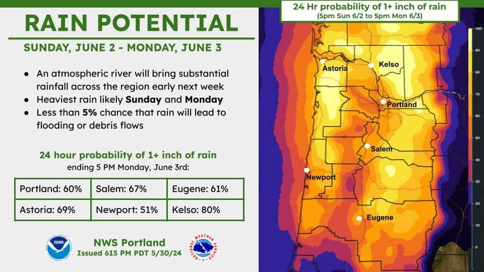
From the National Weather Service/Portland (5/30/24) – An atmospheric river will bring substantial rainfall across the region early next week, with the heaviest rain likely on Sunday and Monday. There is currently a less than 5% chance that rain will lead to flooding or debris flows.
24 hour probabilities of 1+ inch of rain between 5 PM Sunday 6/2 to 5 PM Monday 6/3 are around 50-80% across northwest Oregon and southwest Washington.

Featured Video

Slide Contribute SUBSCRIBE

Tillamook Weather

Tides

Tillamook County Pioneer Podcast Series

Tillamook Church Search

Cloverdale Baptist Church
Nestucca Valley Presbyterian
Tillamook Ecumenical Service

Archives

  • Home
  • EULA Privacy Policy
  • Contact
  • Opt-out preferences
  • Search...
Share on facebook
Facebook
Share on pinterest
Pinterest
Share on twitter
Twitter
Share on linkedin
Linkedin
Catherine

Recent Posts

  • Tillamook FFA Excels in State Career Development Events: Two Teams Headed to Nationals

    May 12, 2025
  • Tillamook Police Department Invites Community for Coffee with a Cop May 14th

    May 12, 2025
  • GORDON'S WEEKLY WEATHER UPDATE 5/12/25: Showery Pattern Continues Through Week

    May 12, 2025
©2025 | Theme by SuperbThemes

Manage Cookie Consent
To provide the best experiences, we use technologies like cookies to store and/or access device information. Consenting to these technologies will allow us to process data such as browsing behavior or unique IDs on this site. Not consenting or withdrawing consent, may adversely affect certain features and functions.
Functional Always active
The technical storage or access is strictly necessary for the legitimate purpose of enabling the use of a specific service explicitly requested by the subscriber or user, or for the sole purpose of carrying out the transmission of a communication over an electronic communications network.
Preferences
The technical storage or access is necessary for the legitimate purpose of storing preferences that are not requested by the subscriber or user.
Statistics
The technical storage or access that is used exclusively for statistical purposes. The technical storage or access that is used exclusively for anonymous statistical purposes. Without a subpoena, voluntary compliance on the part of your Internet Service Provider, or additional records from a third party, information stored or retrieved for this purpose alone cannot usually be used to identify you.
Marketing
The technical storage or access is required to create user profiles to send advertising, or to track the user on a website or across several websites for similar marketing purposes.
Manage options Manage services Manage {vendor_count} vendors Read more about these purposes
View preferences
{title} {title} {title}