Menu
  • Home
  • Breaking News
  • Feature
    • Arts
    • Astrology
    • Business
    • Community
    • Employment
    • Event Stories
    • From the Pioneer
    • Government
    • Letters to the Editor
    • Non Profit News
    • Obituary
    • Public Safety
    • Podcast Interview Articles
    • Pioneer Pulse Podcast: Politics, Palette, and Planet – the Playlist
  • Weather
  • Guest Column
    • Perspectives
    • Don Backman Photos
    • Ardent Gourmet
    • Kitchen Maven
    • I’ve been thinking
    • Jim Heffernan
    • The Littoral Life
    • Neal Lemery
    • View From Here
    • Virginia Carrell Prowell
    • Words of Wisdom
  • Things to do
    • Calendar
    • Tillamook County Parks
    • Tillamook County Hikes
    • Whale Watching
    • Tillamook County Library
    • SOS Community Calendar
  • About
    • Contribute
    • Advertise
    • Subscribe
    • Opt-out preferences
  • Post Submission Test
  • Search...
Menu

GORDON’S WEATHER UPDATE – EXTRA 11/20/24: More “fun” weather to come tomorrow…

Posted on November 20, 2024 by Editor

By Gordon McCraw, Meteorologist for the Tillamook County Pioneer

Well, that was a lot of fun! It looks like the Tillamook area saw around 1 to 1 ½” of rain in the last 24 hours. This was expected to be a wind event, and it didn’t disappoint, though we saw some lower gusts than expected, Tillamook saw winds gusting to 39 while Manzanita reported a gust to 46. If you went down to Lincoln County, Yaquina Bay Bridge hit 73. This still managed to cause some sporadic power outages as trees downed some lines from Netarts to Nehalem.

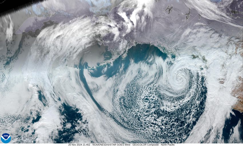
The low pressure area responsible for all this still looks impressive as it continues to spin west of Vancouver Island. This is rotating showers with some thunderstorms northeastward across the area so, there is a chance we could see a few more tonight, and we continue to have southeasterly winds 5-10 gusting to 20 tonight, the low near 42.

This was so much fun, Mother Nature has decided to give us a round two, starting tomorrow. It appears another low pressure area will develop west of California and rotate under the one mentioned above, then move up towards Washington. The issue is, just how strong will this low be, and just how far off the coast it will be. The current thinking for tomorrow is, we see more showers with the winds southwesterly 5-10, the high near 54, then tomorrow night we see more showers with the wind increasing to 10-15 gusting to 25 by tomorrow night, lows near 45.

It appears the winds peak Friday afternoon, with the rainy skies, the southerly winds becoming 20-25 gusting to 35, then we transition to showers Friday night, the winds slowly easing, becoming southwesterly 5-10, highs near 56, lows near 41. As far as how much moisture will this next system bring, it appears we are looking at another 1-2” of rain for Thursday/Friday. This is good news for the rivers as that threat remains low.

It continues to look like the weekend will be semi-wet with more showers around Saturday and Sunday, highs near 51, lows near 39.

Featured Video

Slide Contribute SUBSCRIBE

Tillamook Weather

Tides

Tillamook County Pioneer Podcast Series

Tillamook Church Search

Cloverdale Baptist Church
Nestucca Valley Presbyterian
Tillamook Ecumenical Service

Archives

  • Home
  • EULA Privacy Policy
  • Contact
  • Opt-out preferences
  • Search...
Share on facebook
Facebook
Share on pinterest
Pinterest
Share on twitter
Twitter
Share on linkedin
Linkedin
Catherine

Recent Posts

  • NEHALEM BAY STATE PARK TO OPEN DAY-USE AREAS, BOAT LAUNCH MAY 23, CAMPGROUND REMAINS CLOSED

    May 14, 2025
  • MANZANITA FARMERS MARKET OPENS FRIDAY MAY 16TH!!

    May 14, 2025
  • Vote NO on Increasing Taxes in Tillamook County

    May 14, 2025
©2025 | Theme by SuperbThemes

Manage Cookie Consent
To provide the best experiences, we use technologies like cookies to store and/or access device information. Consenting to these technologies will allow us to process data such as browsing behavior or unique IDs on this site. Not consenting or withdrawing consent, may adversely affect certain features and functions.
Functional Always active
The technical storage or access is strictly necessary for the legitimate purpose of enabling the use of a specific service explicitly requested by the subscriber or user, or for the sole purpose of carrying out the transmission of a communication over an electronic communications network.
Preferences
The technical storage or access is necessary for the legitimate purpose of storing preferences that are not requested by the subscriber or user.
Statistics
The technical storage or access that is used exclusively for statistical purposes. The technical storage or access that is used exclusively for anonymous statistical purposes. Without a subpoena, voluntary compliance on the part of your Internet Service Provider, or additional records from a third party, information stored or retrieved for this purpose alone cannot usually be used to identify you.
Marketing
The technical storage or access is required to create user profiles to send advertising, or to track the user on a website or across several websites for similar marketing purposes.
Manage options Manage services Manage {vendor_count} vendors Read more about these purposes
View preferences
{title} {title} {title}